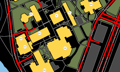
The University of Waterloo Campus Map is an accessible, mobile friendly campus map that not only shows every twist and turn on campus, but also has information on transit stops, food options, parking, ATMS, and places under construction [1].
 The UWaterloo’s Open Data API is powered by the Open Data Initiative. Open Data API allows anyone to build their own programs and applications using data from the UWaterloo websites [2].
Accessibility, mobility, and the profound relationship between the two were key factors in building the UWaterloo campus map. Some of the accessibility features include supporting keyboard navigation, tabular views of the data, and a high contrast version of the base map. The high contrast version of the base map is useful for those who have impaired vision or colour blindness. This version is also beneficial for viewing the map outside, even under extreme exposure from the sun. Furthermore, this article will cover notable features available on the UWaterloo Campus Map [1].
Navigating the University of Waterloo Campus Map
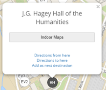 The + and – buttons at the top right corner of the website are used to zoom in and out of the map. In addition, clicking on any building will display the full name of the building, give directions to or from the location, and allow the location to be added as the next destination.
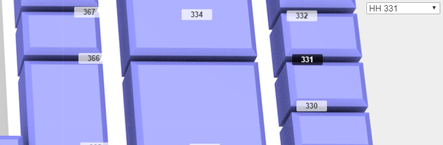
One of the many cool things about the campus map is the indoor maps feature. Clicking “Indoor Maps” displays individual floorplans of the selected building. Clicking a specific room from the drop down menu highlights the room making it clear where the room is located.
Search
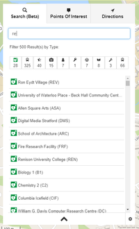 “Search” can be located on the left side of the map. This search bar is very convenient and easy to use.
The search bar is smart enough to search for places without being given a full name. For instance, typing in “HH” will find Hagey Hall and everything else that is associated with “HH” on campus.
In the image on the left, observe that just by typing in “re” it has picked up every place, bus stop, inclusive bathroom, greenspace, etc. that contains “re” in its name. The user can sort these results using the bar located under the search bar and by clicking on the desired category.
Points of Interest
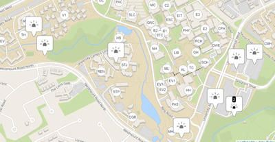
“Points of Interest” is a menu used to locate popular places on campus. This section of the Campus Map can be used to find information for transit, information, parking, accessibility, and emergency services. For example, to find all of the GRT bus stops on campus, simply click “Transit” and then “GRT Stops”. The Campus Map will then adjust to display every GRT bus stop in Kitchener/Waterloo. The waypoints are interactive and clicking them displays further information as well as directions.
Emergency Information
 “Emergency Information” shows locations of emergency services and includes information on who to contact and emergency procedures.
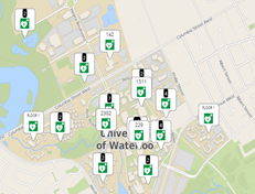
The map displays where all automatic external defibrillators on campus are located. An automated external defibrillator is a device that detects irregular heart palpitations and issues corresponding electrical shocks to restore a normal heart rhythm [3].
“Emergency Information” also helps locate Helplines across campus. Helpline waypoints are located in throughout the UWaterloo and can be used for general inquiries or to report safety issues and emergencies.
Transit
“Transit” shows all GRT Stops, GO Transit stops and Greyhound stops on campus. Clicking on any of the GRT Stops gives access to the GRT Trip Planner where the user can plan trips, see route schedules, stop schedules, next departures, and alerts.
Visitor Information
Clicking on Visitor Information gives directions to the Turnkey Desk in the Student Life Centre (SLC) that can provide visitors with general knowledge. The map will also direct visitors to the Visitor’s Centre.
Parking
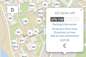 The Campus Map shows all visitor parking lots, meter parking, short term parking, motorcycle parking, accessible parking, and permit parking.
To find out parking space availability, click the parking lot and the information will be displayed.
Accessibility
 Under “Accessibility”, all accessible parking, accessible entrances, and all-inclusive washrooms on campus are displayed.
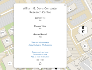
For inclusive washrooms, clicking any of the icons that appear on the map will show whether a bathroom is barrier free, has a change table, and if it is gender neutral. Click “About Inclusive Washrooms” for more information.
Sustainability
Under “Sustainability”, there is information on:
- battery recycling bins
- bike lockers
- bike repair stations
- care share parking spaces
- E-waste drop-off bins
- green spaces
- green roofs
- sustainable food
- textbook drop-off boxes
- water bottle refill stations
Incoming students will find the water bottle refill stations useful as there are sections of campus that are scarce for water.
Directions
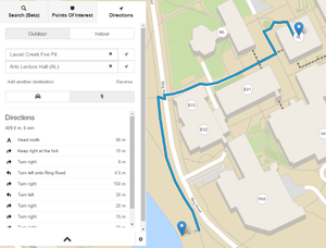 “Directions” displays routes between buildings on campus. The search results can be filtered by selecting if the destination is indoor or outdoor. This feature provides driving or walking directions.
After picking any location, click and drag the blue pin to further refine the destination.
After inputting all the needed information, directions and an estimate of how long it will take will be displayed. The map will also add a blue line that highlights the path to the destination.
References
[1] Toman, S. (2015, September 7). Waterloo's new campus map will help you find your way | Waterloo Stories. Retrieved from https://uwaterloo.ca/stories/waterloos-new-campus-map-will-help-you-find-your-way
[2] Home | Open Data API. (2017, September 18). Retrieved from https://uwaterloo.ca/api/
[3] Definition of Automated external defibrillator. (n.d.). Retrieved from https://www.medicinenet.com/script/main/art.asp?articlekey=23575
[4] Phones & helplines | UW Police. (2016, December 12). Retrieved from https://uwaterloo.ca/police/campus-safety/phones-helplines-0