Introduction
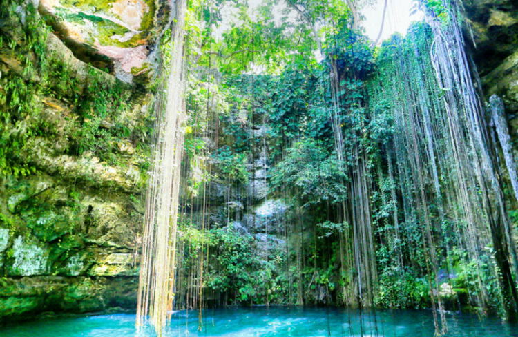
The availability of freshwater is a basic prerequisite for civilization, and is particularly important in tropical karst landscapes, such as that of the Yucatan, Mexico, where there is a general absence of large rivers and lakes. The majority of freshwater found at the many sites associated with classical Mayan civilization is located beneath the surface in subterranean cave networks or underground rivers. Openings that lead into these networks are referred to as “cenotes.” Today, many cenotes are tourist sites, though historically they were spiritually revered for serving the far more important purpose of providing a freshwater source. Climate variability on decadal time scales, and in particular changes in hurricane activity, has been hypothesized to have played a role in the decline of local city states during the late Classical Period of the Mayan civilization.
From the hydrologist’s point of view, freshwater in the aquifer overlies salty water that originates in the sea, and intrudes inland. The well-developed interface between the two is called the halocline, and is readily observable by instrumentation and visually by divers in the cave networks. The aquifer is recharged during rain episodes, especially during the rainy season, typically from June to November. Inflow into the cave networks comes via both the large openings of cenotes, and as a slow flow through the porous karst matrix. Hurricanes, which are rare but extremely powerful events, provide an efficient means for mixing the fresh and salty water, leading to a decrease in the potability of the water in the cenotes. Freshwater generally flows seaward and, near the coast, some of the subterranean networks open. These regions of brackish water are extremely biologically productive and are fringed by mangroves, which provide cover from storm surges and control the manner in which rainwater is distributed.
Methodology
The hydrological environment of the Yucatan presents a host of scientific and modelling challenges on different timescales. This study is part of an ongoing research program, with measurements that attempt to characterize the variation of mixing along the cave axis being analyzed at the time of writing. At the same time, the methods of time series analysis are being used on a variety of cores (e.g. sediment cores) in an effort to extract information of past variations in freshwater availability, with archaeological implications. So far, monitoring was generally achieved by collating information gathered by volunteer divers. This provides extensive information about particular cave networks, though even this information is sparse in terms of coverage of the overall geographic area. Time series analysis can provide information about variability on different timescales, but requires a careful balance between mathematical methods that efficiently provide information for episodic events (e.g. wavelet analysis) and an understanding of the underlying scientific questions.
The current study considered how an extremely powerful weather event, like a hurricane, affects the subterranean environment. We focused on mixing of the fresh and salty water, because an increase in salinity can lead to a decrease in potability. In the modern context this may not seem a pressing issue, given the other impacts resulting from a hurricane’s passage. However, for a classical civilization like the Maya, localized city state regions experienced periods of decline that may be associated with weather events that caused aquifer mixing, resulting in a decrease in the availability of freshwater.
While hydrology is often thought to be the science of water moving through extremely small spaces, like the pores in soil, the cave network is an example of a macroscopic fluid environment. This means flow in the network is often turbulent, meaning highly irregular, with complex spatial patterns of mixing between adjacent layers. To fill the gap in knowledge regarding the Quintana Roo coastal hydrodynamic system, our research considered three approaches to the problem: field data, lab-scale experiments, and numerical simulations.
Outcomes
First we analyzed field data from vertical chains of temperature and salinity sensors in the cave network for time periods before, during and after the hurricane passage. We found that following the hurricane’s passage, a disturbed state with reduced potability of near surface water persisted for more than a month. We also noted that hurricanes were not the only significant events in terms of disturbing the flow in the cave network.
We followed up our field study with both experimental realizations of how a strong rainfall event draining into a cenote may mix the fluid in the cave network, and high-resolution numerical simulations of this process. During all physical experiments, rain appeared to force parts of the halocline downwards, which by conservation of mass results in portions being forced up, eventually resulting in direct mixing of the fresh and salty water. Over time, as more fluid gets pulled into the active region and mixed, the turbulent region grows and fills the entire domain. Numerical simulations allow easy access to variables that may be difficult to measure in experiments or the field. The cost of this access is a simplified cave shape, as it is not possible to simulate the entire, complicated, real-world system.
A key outcome of the simulations was to demonstrate how a region that is being forced and mixed directly (e.g. by rain on an open cenote) results in mixing away from the forcing site (e.g. within a cave network, for which the overlying mud, mangroves and the karst itself provide shielding from direct rain). Assuming that the mangrove peat cover prevents the rainwater from directly permeating into the karst, we would expect that on a regional scale most mixing occurs within the cenotes and then propagates into the aquifer system (Figure 1).
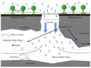
Figure 1. A sketch of the hypothesized dynamics within a cenote or cave opening during a rainfall event.
Conclusions
The major result from the field data is the confirmation of the hypothesis that heavy rainfall results in halocline mixing. Furthermore, there is an extremely high correlation between the known rainfall events and changes in temperature and salinity above the halocline. However, hurricanes were not the only significant events found to disturb the flow in the cave network. When seeking implications for past climate events that may have had an archaeological impact, this implies that looking solely at hurricanes is overly simplistic. Thus, changes in the occurrence rate of El Nino may find, for example, an unexpected expression in local climate and the hydrological cycle of the Yucatan.
This study has also made first strides at understanding the hydrodynamics within a cenote or cave opening during a rainfall event. Future work will attempt to refine how the numerical models represent the complex cave shape.
Coutino, A., M. Stastna, S. Kovacs, and E. Reinhardt (2017). Hurricanes Ingrid and Manuel (2013) and their impact on the salinity of the Meteoric Water Mass, Quintana Roo, Mexico. Journal of Hydrology 551, 715-729.
Contact: Marek Stastna, Department of Applied Mathematics; Aaron Coutino, Department of Applied Mathematics
For more information about the Water Institute, contact Amy Geddes.