


 Contact
 Monica Emelko, Department of Civil and Environmental Engineering
 Michael Stone, Department of Geography and Environmental Management
Introduction
Communities adjacent to forested regions are experiencing more frequent and destructive wildfires associated with a warming climate, exposing them to increased risk of catastrophic impacts. One of these impacts is the degradation of downstream surface water resources resulting from changes in runoff and increasingly variable water quality that can affect aquatic ecosystem functioning and drinking water treatability. Wildfire impacts on water are not well understood in large river systems with relatively low hydrologic connectivity. These attributes are characteristic of many areas across the circumpolar Boreal Forest, where low topographic relief, heterogeneous glacial deposits and extensive peatland landscapes result in relatively low landscape-water coupling.
The primary objective of the study was to assess the impacts of the May 2016 Fort McMurray wildfire in northeastern Alberta, Canada on the water quality of large (>1,000 km2) and low-relief (<5 per cent slope) rivers in the region. In addition, the study assessed if precipitation events mobilized more wildfire-related material relative to non-precipitation periods, and evaluated suspended sediment, dissolved material and flow relationships in rivers draining burned landscapes with pre-fire data from the same river. It was hypothesized that rivers draining burned watersheds would be resistant to unbuffered overland flow and therefore show no detectable differences in water quality relative to rivers draining unburned landscapes or extensive historical data.
Methodology
The study region was located in the Boreal Plains ecozone near Fort McMurray, Alberta. The 2016 Fort McMurray wildfire was the costliest natural disaster in Canadian history and resulted in the evacuation of approximately 90,000 residents and the destruction of approximately 600,000 ha of forest and peatland (Figure 1).

Figure 1: Map of the lower Athabasca River showing the extent and severity of the May 2016 Fort McMurray wildfire and water monitoring stations. Inset (a.) shows monitoring station clustering around Fort McMurray.
Post-fire river water quality monitoring focused on three rivers: the Athabasca, Clearwater and Hangingstone and included four stations (three burned, one unburned). Stations incorporated multiple measurement approaches and, where possible, were co-located near meteorological and flow stations. Multi-probe data sondes were deployed to continuously record water quality at the four stations, while two additional sondes assessed mixing conditions downstream of Fort McMurray. In addition, daily samples and weekly grab samples were collected at the four stations.
To identify periods when wildfire-related material may be mobilized, local precipitation events, and subsequent river flow response periods, were delineated at each station. Hourly and daily flow data before and after the wildfire were retrieved, where possible, from hydrometric stations close to water quality locations. In addition, historic water quality data were used to quantify pre- and post-fire conditions at the three burned stations.
To identify the existence of concentration-dilution and concentration-concentration periods in each river, mean hourly quality and flow data were included in an unconstrained principal components analysis. Covariances of turbidity and conductivity were quantified to directly compare the magnitude and frequency of suspected ash mobilization periods between stations. A laboratory ash-mixing experiment was performed to demonstrate how ash affected turbidity and conductivity measurements in an aqueous solution. Descriptive statistics were used to quantify differences in yields of selected particle-bound and dissolved chemicals between burned and unburned river stations.
Outcomes
Water quality monitoring by sondes typically showed flow-concentration for turbidity and flow-dilution for conductivity and pH, as well as contrasting seasonal changes for water temperature and dissolved oxygen. However, sharp peaks in turbidity and conductivity together occurred during short periods often along the rising limb of the hydrograph at burned stations. Observations were consistent with results of the ash mixing experiment that demonstrated concurrent increases in turbidity, specific conductivity and pH as ash was added to deionized water. Further, though pre-fire grab sampling in impacted rivers showed consistent negative associations between turbidity concentrations and specific conductivity, 11 to 38 per cent of post-fire, precipitation event turbidity and conductivity samples were greater than the upper historic 95 per cent prediction interval, suggesting a more positive association between the parameters during those periods.
Daily automated and grab sample water quality results indicated only slight differences between burned and unburned stations when aggregated to the entire sampling season. Similarly, monthly suspended sediment yields from rivers draining burned and unburned watersheds before and after the fire indicated no fire effect. Substantial differences occurred within and between stations when classifying data by precipitation event and non-event periods. At burned stations, peaks of concentrations and yields during precipitation events were observed relative to non-event periods for suspended sediment, total phosphorus, total Kjeldahl nitrogen and total lead. In contrast, ratios at the unburned station were lower and often near unity.
Elevated suspended sediment concentrations observed at burned stations did not result from higher flows than sampled historically, nor changes in the hydrological conditions of impacted river systems. Collectively, suspended sediment concentration exceedances of historic 95 per cent prediction intervals in impacted rivers became more frequent as watershed size decreased, and the proportion of burned area and area burned at high severity across watersheds increased (Figure 2). Following the wildfire and precipitation events, both low- and high-order tributaries draining severely burned watersheds delivered plumes of ash to the Athabasca River that were visible for several kilometers downstream of confluences (Figure 3).
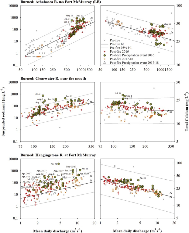
Figure 2. Log-scaled concentration-discharge relationships of suspended sediment and total calcium (Ca) of historic and post-fire data from three rivers draining burned watersheds in the lower Athabasca River region following the 2016 Fort McMurray wildfire. The 95 per cent prediction intervals and linear fit lines on historic data are also shown.
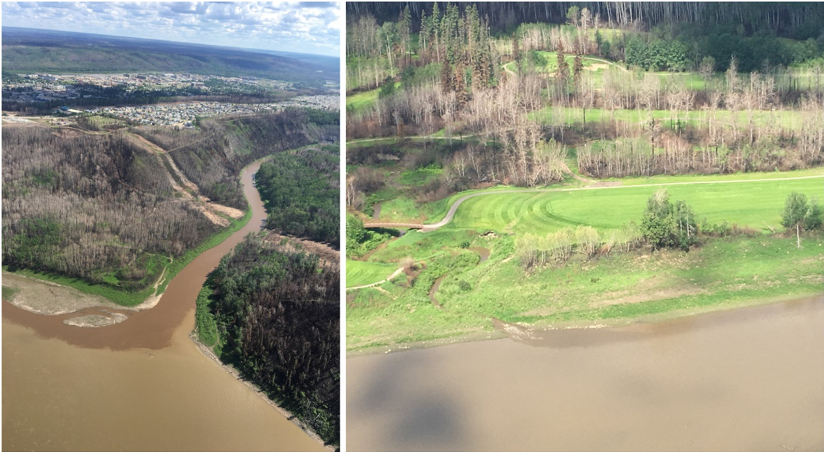
Figure 3: Photos of high-order (left panel; Horse River) and low-order (right panel; Little Fisheries Creek) rivers draining recently burned watersheds and discharging into the Athabasca River just upstream of Fort McMurray after a June 2016 precipitation event. (Credit: S. Hustins).
Conclusions
Three independent monitoring approaches reported brief, precipitation-related increases in wildfire-related material in rivers draining burned watersheds relative to the unburned station or historic, pre-fire data. Observing such impacts at a large basin scale was surprising and suggests that rainfall-induced surface erosion delivered ash and soil from local, burned hillslopes into large rivers that briefly impacted water quality without shifting overall river water quality relative to unburned regions. While the mobilization of fire-related materials downstream is likely driven by similar processes across differing landscapes, they are shaped by catchment- and fire-related characteristics. It is postulated that incomplete hydro-chemical mixing may play an important role in causing impacts to downstream water treatment plants and to wildfire signal detection in these large rivers. The study highlighted the importance of considering the spatial frame of reference when evaluating wildfire impacts on water quality in large river basins as the impacts can be significant to already challenged systems.
Interestingly, though relatively muted water quality changes in very large rivers were observed compared to headwater regions, these basin-scale effects still resulted in impacts to post-fire drinking water treatment costs borne by the local municipality. Thus, exclusive focus on the magnitude and persistence of the impacts of wildfire on surface water quality may fail to uncover its true stresses on surface water resources. This consideration may be particularly applicable to future wildland-urban interface fires as the export of complex chemicals (e.g., plastics) from residential, commercial, and industrial settings may present unique water quality conditions in receiving waterbodies.
Emmerton, C.A., Cooke, C.A., Hustins, S., Silins, U., Emelko, M.B., Lewis, T., Kruk, M.K., Taube, N., Zhu, D., Jackson, B., Stone, M., Kerr, J.G., & Orwin, J.F. (2020). Severe western Canadian wildfire affects water quality even at large basin scales, Water Research, 183. https://doi.org/10.1016/j.watres.2020.116071
For more information about WaterResearch, contact Mary Anne Hardy.


