


 Contact
 Merrin Macrae, Department of Geography and Environmental Management
Introduction
Lake Erie has a long history of water quality impairment caused by eutrophication. Phosphorus (P) loadings have been a major cause of harmful algal blooms in the shallow western basin, with hypoxia in the deeper central basin and nuisance algal blooms along the eastern basin shorelines. After dramatic improvements in water quality during the 1980s and 1990s, Lake Erie has undergone a period of “re-eutrophication” over the last 20 years.
Extension of field- and watershed-scale research has often led to recommendations for conservation practices to be widely applied across entire regions, such as the Great Lakes. This approach does not account for subtle differences in microclimate, soils and topography that may undermine the efficacy of specific practices or may even produce unexpected adverse outcomes.
The objective of the research was to develop a regional conservation practice suitability framework, using the Lake Erie watershed as a case study, that could be transferred to other watersheds that exhibit varying land characteristics and hydroclimates.
Methodology
The study examines patterns in climate, landscape characteristics and land drainage to define regional differences and identify management regions within the Lake Erie watershed. Climate datasets (i.e., mean annual precipitation and temperature, summer and winter precipitation and temperature, growing degree days) were extracted from 30-year climate records (1990 – 2019) and derived from Daymet which provides gridded weather variables across the region. Average snow cover duration was calculated using Google Earth Engine’s Snow Data Product.
Elevation and slope data were extracted from Google Earth Engine using the Hydrosheds digital elevation model and slope function. Surficial geology was obtained from government sources. Land use was mapped by grouping crop class information into agricultural production systems.
The Google Earth Engine was used to generate the regional classification by using the derived geospatial datasets as input to an unsupervised k-means clustering algorithm to automatically select the most appropriate number of regional classes based on the separability of input datasets. A conceptual understanding and toolkit of how and why different conservation practices were appropriate within different regions was then developed based on a literature review and author experience.
Outcomes
An assessment of regional climates reveals significant differences that influence risks of P loss to Lake Erie (Figure 1). While precipitation is relatively evenly distributed throughout the year, most runoff occurs during the non-growing season (October–April) when the soil moisture storage deficit is low. Although conditions are generally warmer in the southwestern portion of the watershed, the potential for frozen ground is increased because of a lack of snow cover. Frozen or partially frozen ground impedes infiltration of rainfall or melting snow, increasing the potential for surface ponding and overland flow. In contrast, soils in the north and east portions of the watershed are more likely to be protected by the insulating persistent snowpack.
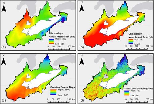
Figure 1: Variability of (a) mean annual precipitation, (b) mean annual temperature, (c) mean cumulative growing degree days (above base temperature of 10°C) and (d) mean snow cover duration, throughout the Lake Erie watershed. Temperature, precipitation, and growing degree day climatologies are derived from NASA's Daymet daily surface weather data from 1990 to 2019. Snow cover duration is derived from NASA's MODIS 500 m daily snow cover product from 2002 to 2019.
A variety of soils and topographic settings exist across the Lake Erie watershed (Figure 2). The southwestern region contains silty loams or silty clay loam soils with lacustrine soils closer to the lake. Toward the north and east, the topography becomes more undulating and texture varies from silt loam to sandy soils with localized clay pockets. These soils have different biogeochemical and hydrological properties that have implications for runoff processes and P transport.
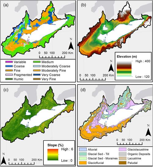
Figure 2: Differences in (a) soil texture class, (b) elevation, (c) slope throughout the Lake Erie watershed, and (d) surficial geology.
Corn–soybean row crops dominate farming systems (Figure 3). The southwestern region is primarily used for row crop production because it has the warmest and longest growing season and the soils are well suited, especially when supplemented with artificial subsurface tile drainage or surface drainage of depressional areas (Figure 2). Artificial drainage is prevalent across the Lake Erie watershed creating a connection for P that would formerly have been retained on fields to be transmitted to surface waters. However, there is limited evidence that these drains increase total water export from the landscape or increase peak flows.
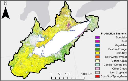
Figure 3: Variability in agricultural production systems in the Lake Erie watershed.
The climate and soil maps (Figures 1 and 2) reveal distinct “endpoints” in the southwestern and northeastern regions of the Lake Erie watershed, with transition conditions on the northern side and southeastern periphery of the watershed. These “endpoints” represent different P management regions based on the potential for P transport or retention on farm fields, whereas P management strategies in the two “transition” areas may be more complex (Figure 4).
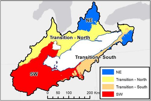
Figure 4: Differing P management regions within the Lake Erie watershed.
Moderate winter and hot summer climate coupled with level clay soils and intensive land drainage make the southwestern region highly vulnerable to elevated P losses from fields. Both surface and subsurface runoff and P loss responses occur throughout the entire year, although the non-growing season dominates annual runoff and P losses. Thus, conservation practices that reduce dissolved or colloidal P in tile drainage year-round should be prioritized in this region. The undulating northeastern region is more vulnerable to particulate P losses associated with surface runoff during distinct peak periods of the year, particularly snowmelt. Conservation practices in this region should emphasize controlling flows during peak periods and reducing erosive processes on the soil surface.
Greater runoff losses of P have repeatedly been observed from fields with greater soil test P, with legacy P having being identified as a significant source. A pressing issue is therefore to revisit nutrient management programs throughout the Lake Erie watershed, evaluate critical environmental and agronomic thresholds, and update recommended P application rates. In addition, a reduction in the stratification of P in the soil profile is needed throughout the watershed, particularly in the southwestern region. This reduction may be achieved through practices such as periodic conservation tillage or subsurface placement.
The efficacy of no-till or conservation till at mitigating P loss may vary across the geographic regions of the Lake Erie watershed. In the southwestern region, an alternative, preferred practice is the coupling of subsurface placement with no-till, which work synergistically to manage P losses in the surface and subsurface. In the northeast region, increased adoption of no-till would likely reduce P losses at the edge of the field due to the significant surface runoff associated with snowmelt.
In the southwestern region, the use of vegetation as cover crops or grassed waterways to mitigate P loss may have unintended consequences as there is a greater risk of dissolved P leaching from vegetation following the many freeze–thaw cycles that occur throughout the winter. In the northeastern region, the use of cover crops and grassed waterways has the potential to mitigate P loss from fields during critical runoff events.
Conclusions
Current estimates of the environmental efficacy and cost-effectiveness of conservation practices are developed based on a limited number of studies and involve a great deal of extrapolation rather than spatially distributed field trials. Consequently, we may not be applying the “right practice” in the “right place” to mitigate P loss from fields. By understanding that different suites of conservation practices may be more appropriate across different P management regions, we achieve a more nuanced and flexible approach in accounting for the cost-effectiveness of different conservation practices and promote trust between farmers, managers, and scientists.
To achieve regionally tailored, adaptive, and cost-conscious conservation practice recommendations for the Lake Erie watershed, the study proposes a five-step plan:
- Refine the proposed P management regions through improved understanding of the interactions, heterogeneity and scale dependence of landscape and climate factors including P losses at the watershed scale.
- Develop region-specific guidance through improved conservation practice catalogues or fertilizer recommendations.
- Refine region-specific guidance with region-specific field trials linked to water quality monitoring and build observations into assessments of cost-effectiveness.
- Communicate results to producers to ensure that the right practices are being used in the right places.
- Implement an adaptive management framework to detect, assess, and mitigate trade-offs in the implementation of conservation practices; to foster collaboration and the sharing of experiences; and to clearly communicate results to producers across the different P management regions.
Although the paper has been specific to the Lake Erie watershed, the approach used is transferable across broader geographic regions, and such an approach could also form guidance for watershed planning exercises.
Macrae, M., Jarvie, H., Brouwer, R., Gunn, G., Reid, K., Joosse, P., King, K., Kleinman, P., Smith, D., Williams, M. & Zwonitzer, M. (2021). One size does not fit all: Toward regional conservation practice guidance to reduce phosphorus loss risk in the Lake Erie watershed. Journal of Environmental Quality, 50, 529-546. https://doi.org/10.1002/jeq2.20218
For more information about WaterResearch, contact Julie Grant.
Listing photo by Chris Ensminger on Unsplash.


