


Contact

Christine Dow
Department of Geography and Environmental Management,
Canada Research Chair in Glacier Hydrology and Ice Dynamics

Introduction
The Antarctic Ice Sheet has been a major contributor to sea level rise over the past several decades. Ice sheet melt has accelerated due to increased contact of warm, salty ocean waters with the continental shelf, ice cavities and glaciers. This is caused by the combined effect of rapid climate warming from human-induced greenhouse gas emissions and a cooling of the Antarctic stratosphere from the human-induced depletion of ozone.
Physical processes taking place at the transition boundary between grounded ice and ice afloat in the ocean – the ice grounding zone - are critical to glacier loss. This study used a unique time series of high-resolution satellite observations and subglacial hydrologic modeling to define an ice grounding zone on the Thwaites Glacier in West Antarctica that expanded and contracted with the tides. In addition, the study helped to explain the role of seawater intrusions on glacial melt and discussed the resultant magnitudes of ice mass loss and sea level rise (Figure 1).
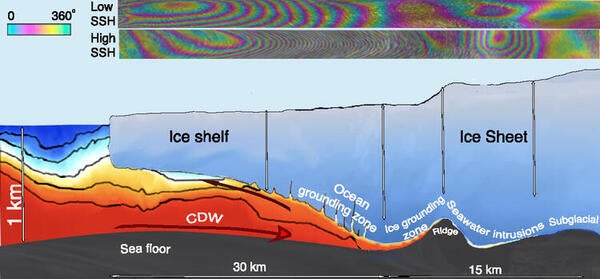
Figure 1: Ocean grounding zone vs. ice grounding zone of an ice sheet/ice shelf system. Circumpolar deep water (CDW) filling the ice cavity is colour coded by temperature from blue (cold) to red (warm). The ocean grounding zone is always flooded with CDW, while the ice grounding zone alternates between flooded and unflooded phases driven by changes in oceanic tide and atmospheric pressure. Seawater intrusion propagates beyond the ice grounding zone at irregular intervals. Under grounded ice, the glacier bed is overlaid by a thin sheet (10 cm) of pressurized subglacial water, which facilitates intrusion and hydraulic jacking of the ice due to seawater. The panel on the Top shows differential, interferometric fringes associated with ice flexing in the ocean and ice grounding zones at low (Top) and high sea surface height (Below). Bull’s eye deformation fringes farther upstream reflect ice subsidence vs. uplift around a bed depression at low vs. high sea surface height.
Methodology
The study area was the Thwaites Glacier, which drains an area of 192,760 km2 and has an ice volume above sea level that is equivalent to a 65-cm global sea level rise. During 1992 to 2011, the glacier’s grounding line retreated at 1 km/y, one of the fastest retreat rates in Antarctica. Between 2011 and 2017, the retreat rate decreased by about half.
A dense time series of synthetic-aperture radar interferometry observations of the Thwaites Glacier was acquired in Spring 2023. The study applied Differential Interometric Synthetic Aperture Radar (DInSAR) to precisely locate the glacier grounding zone and to define its short-term migration. Changes in sea surface height were calculated using the CATS2008 tidal model at a location off shore in front of Thwaites.
Subglacial hydrology was reproduced using the 2D finite-element Glacier Drainage System (GlaDS) model, which predicts the presence of long subglacial channels and an adjacent high-pressured distributed drainage system. The model calculated subglacial water production, water discharge, and water pressure beneath the Thwaites and allowed for the coincident temporal and spatial development of both distributed and channelized systems.
Outcomes
The study found the ice grounding zone to stretch 6 km inland in the central part of Thwaites Glacier with shallow bed slopes and 2 km inland along its flanks with steep basal slopes. A portion of the ice grounding zone abuts a bedrock ridge (Mouginot Ridge) that provides a temporary barrier against glacier retreat as its bed elevation rises inland. Further inland is a second ridge (South Ridge) after which the bed elevation drops significantly, accelerating any glacier retreat which may not stop until the entire basin drains to sea.
The study revealed a slow change in the grounding line position, except at the top of the tidal cycle where the differential sea surface height signal was large and the limit of tidal impacts well defined. Along the main trunk of Thwaites, the analysis detected a vertical motion beyond the ice grounding zone attributed to seawater intrusion that occurred on an irregular basis with extreme events. In most cases, this seawater intrusion “bull’s eye” moved in phase with the change in sea surface height, consistent with seawater rushing beneath grounded ice and lifting it up. At the upper part of the tidal cycle, the study detected seawater intrusions up to 12 km inland. In other cases, the seawater intrusions were out of phase with sea surface height, indicating that seawater was trapped in the cavity or being flushed out. Seawater intrusion was also identified in the northern flank of South Ridge, but was disconnected from that in the main trunk (Figure 2).
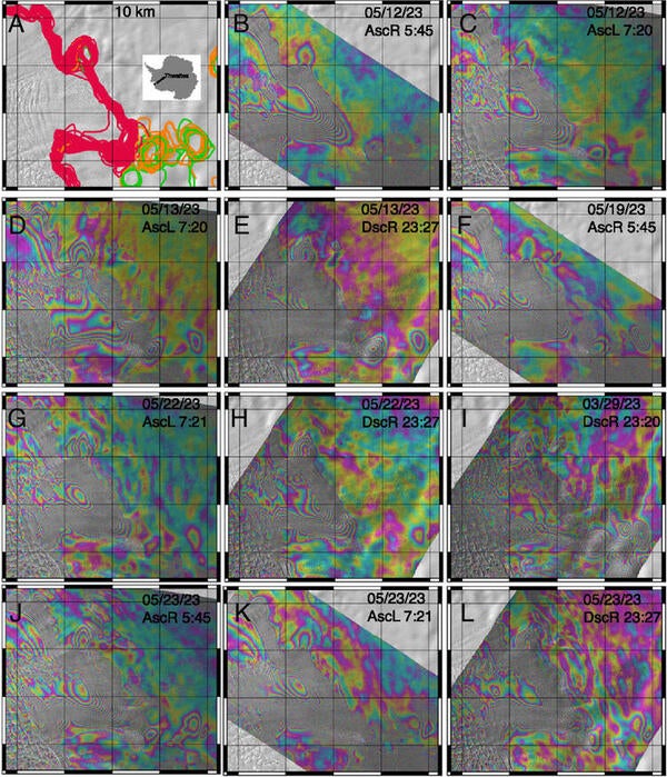
Figure 2: Grounding line positions on the main trunk of Thwaites Glacier in March–June 2023. (A) Red lines delimit regions moving in phase with changes in SSH or the ice grounding zone. Orange lines delineate irregular seawater intrusion moving in phase with SSH and green lines delineate seawater extrusion out of phase with SSH. (B–L) Example differential interferogram (DInSAR) with Ascending Right (AscR), Ascending Left (AscL) and Descending Right (DscR) looking geometry and Descending (Dsc) right looking geometry at different UTC time.
Subglacial Antarctic hydrology is a system at near-steady state in contrast to seasonal systems observed in Greenland and in mountain glacier which instead develop during summer melt and shut down during the winter freeze. Because of the lack of seasonality in Antarctica, the subglacial system is highly pressurized, which facilitates seawater intrusion and hydraulic jacking at high sea surface heights. GlaDS predicted an average water thickness of 8 ± 1 cm in the main trunk of Thwaites with little spatial variability, and a set of subglacial channels aligned with bed troughs with discharges up to 40 m3/s. The bull’s eye of seawater intrusions near the ice grounding zone aligned between two GlaDs channels over an area of high-water pressure while subglacial channels were predicted in narrow zones of lower water pressure, coincident with bed troughs (Figure 3).
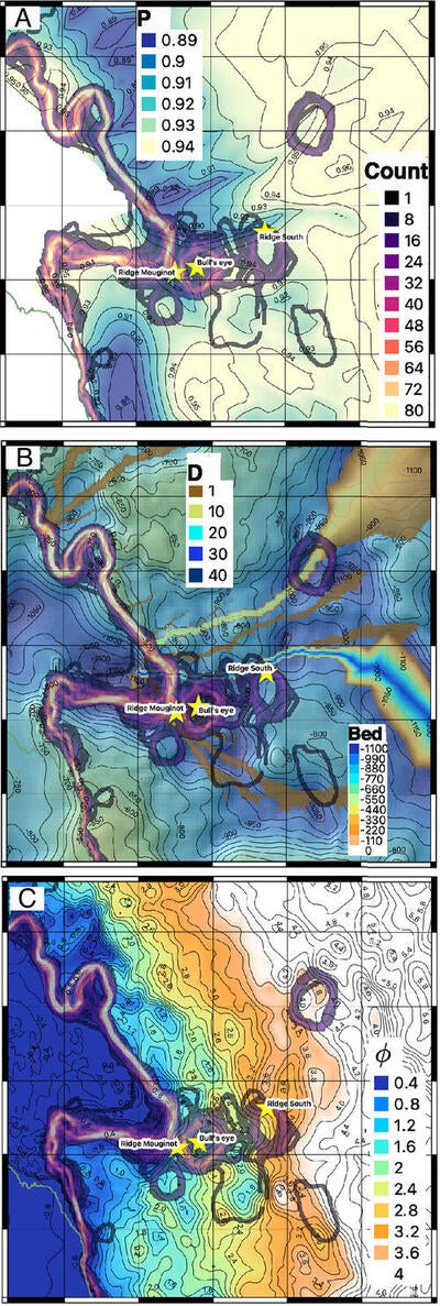
Figure 3: Ice Grounding Zone vs. GlaDS subglacial hydrology. Counts of grounding line position color coded from black (low, 1) to purple and yellow (high, 80) overlaid on (A) water pressure, P, as fraction of overburden pressure; (B) water discharge, D, from 0 to 40 m3/s, overlaid on bed topography from 0 to 1,100 m; and (C) hydraulic potential, ϕ, from 0.4 to 4.0 MPa; along with location of “Ridge Mouginot” and “Ridge South” ridges, and "Bull’s eye.”
Conclusions
The study documents a kilometer-size ice grounding zone, or region of tidally controlled migration of the transition boundary between grounded ice and ice afloat in the ocean, at the main trunk of Thwaites Glacier, West Antarctica. In addition, irregular seawater intrusions occurring at tidal frequencies over many kilometers beneath the grounded ice were detected. Seawater intrusions aligned well with regions predicted to host a high-pressure distributed subglacial hydrology system situated in between lower-pressure subglacial channels. Pressurized seawater intrusions will induce vigorous melt of grounded ice over kilometers, making the glacier more vulnerable to ocean warming, and increasing the projections of ice mass loss. Kilometer-wide, widespread seawater intrusion beneath grounded ice may be the missing link between the rapid past and present changes observed in ice sheet mass compared to the slower changes replicated by ice sheet models and therefore these important processes should be incorporated into future ice dynamic modelling efforts.
Read more in the Proceedings of the National Academy of Sciences: Earth, Atmospheric, and Planetary Sciences.
Rignot, E., Ciracì, E., Scheuchl, B., Tolpekin, V., Wollersheim, M., Dow, C. Widespread seawater intrusions beneath the grounded ice of Thwaites Glacier, West Antarctica. Proceedings of the National Academy of Sciences: Earth, Atmospheric, and Planetary Sciences. May 20, 2024. https://doi.org/10.1073/pnas.2404766121
For more information about WaterResearch, contact Julie Grant.
Listing Photo of Thwaites Glacier by NASA.


