


Contact

Rebecca Rooney
Department of Biology

Casey Remmer
Department of Biology
Catriona Leven
Department of Biology
Introduction
 The Columbia Wetland complex is located in the only undammed portion of the 2000 km long Columbia River and is a rare example of a North American river system with relatively little disturbance from human infrastructure. Declining river flows in the upper Columbia River have reduced the area of open water wetlands in its floodplain and raised concern that the ecosystem will not remain viable under increasing climate change. While the hydrology of the Columbia Wetlands is dominated by seasonal flood pulses, their water budgets are unknown.
The goal of this study was to use stable isotope tracers to quantify the amount of groundwater, river water and precipitation inputs to the water budgets of the Columbia Wetlands in the spring, summer and fall seasons. The study hypothesized that i) snowmelt runoff plays an important role in the spring, ii) river water inputs coincide with the peak flood pulse in late June and early July, and iii) groundwater sources are more important in the fall and spring when the river water is less influential. The role of evaporation in determining wetland water levels was also assessed with the hypothesis that i) evaporation to inflow ratios would display both spatial (increasing with increased isolation from the river) and seasonal (highest in summer and fall) patterns.
Methodology
The upper Columbia River flows northwest between the Rocky Mountains and Purcell Mountains in southeastern British Columbia, Canada. Its floodplain is a complex of wetland types; some retaining surface water over the winter, while others drain almost completely. In some years, wetlands receive turbid peak floodwaters for a short period of time, while in others river water will aggrade the flood basin floor. Different types of wetlands are characterized by different vegetative communities, including those less connected to the river and receiving less flood water.
River, groundwater and wetland water samples were collected during the spring, summer peak flood and fall periods of 2019 (Figure 1). Water isotopes (δ18O and δ2H) were measured by Off-Axis Integrated Cavity Output Spectroscopy (O-AICOS). For each wetland, the isotopic composition of input water was estimated as the intersection of a predicted, lake-specific Local Evaporation Line (LEL) and the Local Meteoric Water Line (LMWL) using the coupled isotope tracer approach.
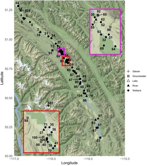
Figure 1: Location of sampling sites in the upper Columbia Valley, British Columbia. Rivers are denoted as a triangle, wetlands as a circle, groundwater as a cross and Columbia Lake as a square.
The R simmr package was used to estimate the proportion of wetland input water attributable to groundwater, river water or precipitation based on calculated δ2H and δ18O and measured electrical conductivity. The isotopic composition of rainfall was estimated using mean and standard deviation of the modelled monthly value of each wetland site extracted from the OIPC v3.2 data base for each sampling period. The model was run separately for each sampling period and proportions were calculated for each wetland individually.
Outcomes

Figure 2: Water isotope (δ18O-δ2H) compositions of the river, groundwater, wetlands and Columbia Lake sampled in the (a) spring, (b) summer and (c) fall of 2019.
To further investigate the role of snowmelt in spring groundwater, boxplots of δ18O, δ2H and electrical conductivity for each input water source were generated. Overlap between groundwater and snow values suggest that groundwater is being recharged from the high elevation snowpack in bordering mountain ranges (Figure 3).

Figure 3: Boxplots of δ18O, δ2H and electrical conductivity (EC) values of groundwater, snow, rain and river water in the Columbia River Valley during the spring, summer and fall of 2019.
To determine the proportion of wetland water contributed by groundwater, river water and rainfall inputs, a three-component mixing model was applied using δ18O, δ2H and electrical conductivity as tracers. Wetlands contained a mean proportion of 47%, 56% and 21% river water, 32%, 25% and 38% groundwater and 17%, 18% and 41% precipitation during the spring, summer and fall respectively (Figure 4).

Figure 4. Proportion of water attributed to groundwater by Bayesian mixing model in wetlands in the upper Columbia Valley sampled in the spring (a), summer (b) and fall (c) of 2019.
Conclusions
Under predicted climate change induced increases in discharge during the winter and spring season in the upper Columbia River, and decreased discharge during the summer, wetlands may become increasingly reliant on groundwater and precipitation-derived water input sources as peak river flow declines. Improving our understanding of local water budgets and, in particular, the role of groundwater on these ecosystems is therefore imperative to making informed management and conservation decisions.
This study found that there was strong seasonality of input water sources across the ice-free season with wetlands primarily sustained by a mix of groundwater or river water in the spring, by river water during the summer peak flow and by rainfall or groundwater in the fall. The study found that groundwater was primarily derived from alpine snowmelt originating in surrounding mountain ranges and was an important source of input water to several wetlands particularly in the spring. No spatial relationship between the influence of evaporation on the wetland water balance and the wetland’s distance from the main river stem was detected.
Future studies would benefit from the inclusion of additional water chemistry tracers to distinguish input sources and potentially improve the reliability of the model. Additional stable isotope-based research to better resolve the relationship between precipitation and groundwater would be useful in this landscape, as would further investigation into the residence time of the groundwater.
Read more in Canadian Water Resources Journal
Remmer, C. R., Rooney, R., Bayley, S., Leven, C. The importance of groundwater to the upper Columbia River floodplain wetlands. Canadian Water Resources Journal, Volume 49, 2024. https://doi.org/10.1080/07011784.2023.2234869
For more information about WaterResearch, contact Julie Grant.


