


Increased environmental awareness has fostered a growing recognition of the need to restore, or more commonly, to reclaim land where disturbed land is converted to a self-sustaining and ecologically more productive condition.
Wetlands are one type of land cover that has undergone dramatic losses both globally and nationally. Scientists estimate that the world has lost 64 to 71% of wetlands since 1900. In Canada, this is due mainly to drainage and conversion of wetlands to agriculture or urban land uses. These losses are especially grave because wetlands provide a large number of important ecosystem services to humans such as water filtration, flood mitigation, or waterfowl habitat. As such, wetlands are of particular reclamation interest because they are both economically and ecologically valuable.
Since wetlands affect and are affected by their surrounding landscapes, to be sustainable, reclamation efforts should include information about the local properties of individual wetlands, the patterns of the broader landscape, and how the two are linked. One approach to improving large-scale reclamation in wetland-rich landscapes is to mimic the proportional composition and the spatial configuration of wetlands found in natural and undisturbed landscapes. To enable reclamation to mimic these natural landscapes, we measured these two features of land cover along a gradient of human disturbance and across different natural regions (boreal, parkland, grassland) in Alberta. The range of composition and configuration measurements can be used to guide the design and assessment of reclaimed landscapes to ensure they replicate natural patterns, which is expected to increase their likelihood of success.
Methodology
Contemporary literature describes hundreds of potential metrics that can be used to describe different landscape properties (e.g. aggregation, area/perimeter, diversity, shape). Using geographical information systems to prepare wetland and crop inventory data, we computed a total of 47 metrics using the Fragstats software. We then explored different data reduction techniques to identify a subset of metrics that could be used as design criteria for wetland landscape reclamation. Metrics chosen were concise, relatively simple to operationalize, and explained the majority of the variance in the landscapes analyzed. Correlation analysis was used to remove highly correlated metrics, and Principal Component Analysis was performed to reduce the number of metrics to a parsimonious and manageable number for industry and regulators. The end result is a selection of metrics that are robust and ecologically relevant.
Ten statistical measurements (i.e. landscape metrics) were identified, from the 47 that were assessed, that capture the composition and configuration of wetland-rich landscapes. These landscape metrics describe the shape of the wetlands within the landscape, the pattern of connectivity among wetlands and other open water habitats, and the diversity of different land cover types.
We applied the ten landscape metrics to each of 3343 landscapes of 1 km2 in size, randomly sampled across the grassland, parkland, and boreal regions of Alberta at different levels of human disturbance (Figure 1). The 1 km2 spatial scale reflected our aim to provide guidance on landscape-level monitoring and reclamation planning as it represents a typical disturbance footprint associated with resource extraction developments in Alberta. The landscape squares in Figure 1 have been enlarged to enhance visibility. We measured disturbance as the proportion (%) of each 1 km2 sample landscape comprised of agriculture, pasture, and transportation or built-up areas, in contrast with natural land covers such as forest or native prairie. Although a 1 km2 landscape size was determined to be the most relevant to our objectives, the methodology can be applied to monitoring and evaluating landscapes of different spatial extents.
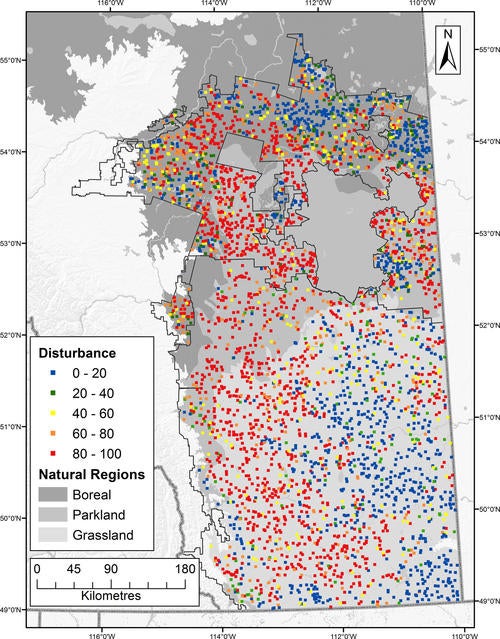
Figure 1. Map of disturbance intervals for the 1 km2 landscapes.
Outcomes
Our evaluation of the composition and configuration of wetland-rich landscapes identified important differences in landscape metrics across a gradient of disturbances and by natural region. Our general findings are:
- Landscapes metric values differ as expected significantly among low and high disturbance landscapes.
- Landscape patterns differ among grassland, parkland, and boreal natural regions. Therefore, different landscape metric distributions should be used for wetland reclamation in each natural region.
- Landscape metrics in low disturbance landscapes are not tightly clustered around a mean value, reflecting a natural range of variability in landscape configuration and composition.
Conclusions
Perhaps the most important recommendation from our results is that landscape planners are advised that the cumulative outcome of reclamation projects reproduces the frequency distribution observed for the ten representative metrics identified in this study rather than targeting a single value for the landscape metrics. This will ensure natural variability is maintained, and avoids the risk of reclamation homogenizing landscape structure and producing “cookie-cutter” landscapes.
This distribution-based approach to reclamation planning requires: (1) a benchmark of landscape metric values creating the distribution; (2) monitoring and documenting reclamation projects to ensure the distribution is maintained; (3) an evaluation of the costs associated with the different landscape configurations; and (4) a decision-making rule or policy that rewards reclamation efforts that span the distribution and costs of different landscape configurations.
The services provided by wetland functions are reliant in part on landscape configurations and not merely composition. It is therefore important to evaluate landscape configuration as well to inform reclamation strategies and long-term monitoring. Future research is needed to develop comprehensive targets for landscape configuration in reclamation plans and a framework that can address the cumulative effect of these large scale reclamations on the distribution of a sufficiently broad but manageable set of landscape metrics.
Evans, I.S., D.T. Robinson, and R.C. Rooney (2017). A methodology for relating wetland configuration to human disturbance in Alberta. Landscape Ecology 32, 2059.
Contact: Derek T. Robinson, Department of Geography and Environmental Management; Rebecca C. Rooney, Department of Biology
For more information about the Water Institute, contact Amy Geddes.


