


Surges and glacier avalanches are expressions of glacier instability and are among the most dramatic phenomena in the mountain cryosphere. To better understand the relationship between glacial melting and climate change, researchers are seeking insight into the mechanisms behind avalanches, particular those which are unusually catastrophic.
The collapse of the Kolka Glacier in the Caucasus Mountains in 2002 that claimed 120 lives and travelled 18 km down-valley, had been considered a globally singular event. Two similar, massive glacier collapses in the western Tibetan Plateau, in 2016, have changed this picture, opening up critical questions about the causes of the detachments and the potential for comparable catastrophic events to occur in mountain glacial environments elsewhere. The first collapse (termed Aru-1) occurred on July 17, 2016. A massive volume of ice detached from the lower part (5,800–5,190 metres above sea level m.a.s.l.) of an unnamed glacier in the Aru Range (Rutok County, China). The fragmented ice mass slid 6 km downslope, killing 9 yak herders along with their livestock, eventually reaching the Aru Co lake (~4,970 m.a.s.l.). The location is shown in Fig. 1 and can be viewed on Google Earth at 34.0389°N,82.3086°E. The horizontal distance travelled by the glacier avalanche was 8.2 km and its vertical drop of 800 m yield a surprisingly low angle of reach of only 5–6°, indicating very low basal friction in the movement. The ice debris covered 8–9 km2 and using pre- and post-collapse differencing using digital elevation models (DEMs), a volume of the detached glacier of 68 ± 2 × 10⁶ m3 was calculated (Fig. 2). The avalanche generated an impact wave, which inundated the opposite shore of Aru Co over a shoreline distance of 10 km, extending up to 240 m inland and 9 m above lake level.
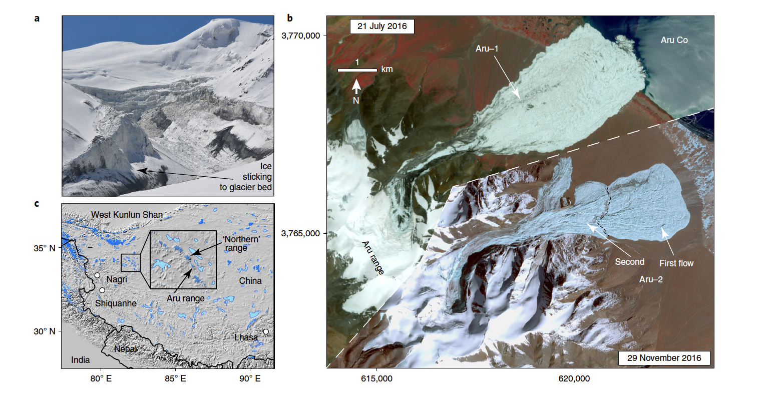
Figure 1: Satellite and terrestrial images of the Aru glacier collapses. A) photo of the upper Aru-2 detachment zone (Oct. 4, 2016). B) mosaic of a Sentinel-2 image of Aru-1 collapse (July 21, 2016) and a Planet image of Aru-2 collapse (Nov. 29, 2016); coordinates: metres in WGS84 UTM zone 44; the image centre is approximately 34.03° N/82.28° E. C) overview of the study region with the meteorological stations used in the analysis. Reprinted by permission from Springer Nature.
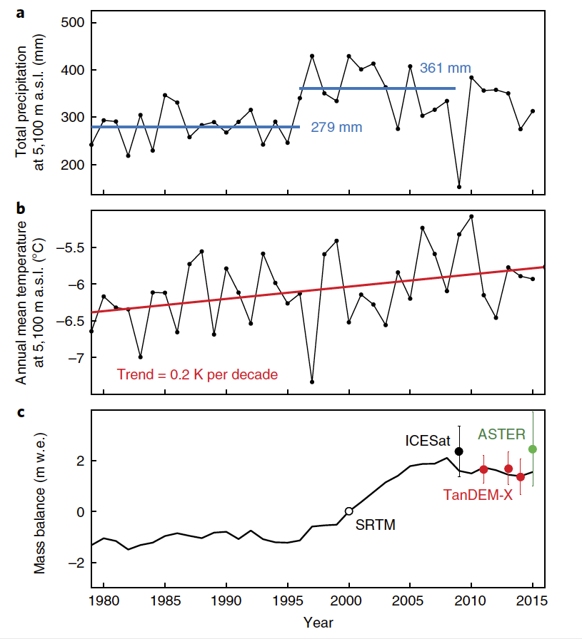
Figure 2: Climatic data series and modelled mass balance of the Aru glaciers. A) precipitation over the Aru Range from ERAinterim reanalysis, suggesting a distinct increase at around 1995. The bold lines are averages for 1979–1995 and 1995–2008. B) air temperature over the Aru Range from ERA-interim reanalysis with a positive trend of 0.2 ± 0.1 K 10 yr−1. C) modelled cumulative glacier water equivalent (w.e.) mass balance of the Aru glaciers, driven by ERA-interim reanalysis. The model is relative to the year 2000 (SRTM DEM), and the parameters were tuned using geodetic mass balances (ICESat, 2003–2008; SRTM-X versus TanDEM-X, 2000– 2011/2013/2014; ASTER, 2000–2015, end points indicated). Reprinted by permission from Springer Nature.
When we examined the aftermath, we noticed the glacier, in an adjacent valley (Aru-2), was cut with large crevasses, similar to those seen in earlier satellite images of its collapsed neighbour, Aru-1. A warning was issued that the second glacier could collapse, and on September 21, 2016 it did. The detachment on Aru-2 occurred at 5,800–5,240 m.a.s.l. in two main flows (Fig. 1; see also Google Earth image). Similar to the July event, the glacier mass fragmented and transformed into a mass flow that ran out 5 km beyond the glacier terminus, reaching 4,965 m.a.s.l. Over a horizontal distance of 7.2 km, the vertical height of the path was 830 m, giving a similarly low fahrböschung of 6–7°. The glacier debris in the second collapse covered 6–7 km2 with a detached glacier volume of 83 ± 2 × 10⁶ m3 .
Methodology
Our team, led by professor Andreas Kääb from the University of Oslo, consisted of 19 researchers from 7 countries. Our aim was to better understand if the twin Tibetan glacier events were related and to understand what processes led to such dramatic collapses. We used remote sensing, mass-balance modelling, and field investigation to describe these events and reconstruct their evolution since the 1960s. We analyzed glacier dynamics and glacier ice thermal conditions to understand the stress and frictional regime of the collapsed glaciers. In a final step, we discussed the influences of climate variables (temperature and precipitation), bed lithology and glacier geometry on the twin collapses.
Outcomes
We found that the twin collapses were related to warming temperatures and increased precipitation (Fig. 2), acting on specific polythermal and soft-bed glacier properties leading to catastrophic glacier instability. Warmer temperatures increased melting at the downslope end of the glacier, and increased snowfall led to a build-up of mass upslope. These factors converged to produce surge-like movements through the enhancement of driving stresses and massively reduced basal friction connected to subglacial water and fine-grained bed lithology, to eventually exceed collapse thresholds in resisting forces of the glacier tongues frozen to their bed. Our findings show that large catastrophic instabilities of low-angle glaciers can happen under rare circumstances without historical precedent.
There is no evidence of a single trigger (e.g. seismic shock) for the twin collapses. The surge-like behaviour, climate-driven glacier surface steepening, polythermal glacier structure, their geometry and slope, and liquid water from melt and rain during the summer of 2016 are all factors found for a number of other glaciers both on the Tibetan Plateau and elsewhere. We suggest that a transient convergence of factors acting at different spatial and temporal scales caused the Aru collapses.
Further, a polythermal glacier regime, glacier morphology and bedrock lithology represent important precollapse conditions. Over timescales of 15–20 years, the simultaneous increase in temperature and precipitation has acted on the glacier geometry and basal friction by respectively increasing the slope and enhancing liquid-water input to the glacier bed, and possibly expanding the area of thawed conditions. The presence of cold-based fronts and margins prevented the glaciers from adjusting their geometries to changed driving stresses and frictional conditions. This continuously increased the stresses on the frozen terminus and margins, until reaching a critical point where the resisting forces were eventually overcome and the collapses occurred.
The sustained exceptional conditions of low friction over large parts of both glaciers make the events unique and are probably associated with a particular response of the fine-grained basal till to large amounts of liquid water. The final trigger is thought to be linked to short-term variation in the subglacial hydrological system induced by the unusually high water input from melt and rain in the summer of 2016. Hydro-thermodynamic feedback potentially played a role as well – a mechanism by which water reaching the glacier bed through crevasses increases basal sliding, strain and associated fracturing through a combination of thermal and dynamic changes, thus facilitating additional water input and modifying subglacial drainage.
Conclusions
In conclusion, we demonstrated that the Aru twin glacier collapses represent a new form of glacier instability of an entire valley glacier. These collapses seem possible through a rare but not unique array of factors that coalesce to an anomalous increase in driving stresses, and rapid and sustained reduction of basal friction through the development of sub-glacial water pressures. It is spectacular and completely unprecedented that such combined exceedance of stability thresholds, highly unlikely for one glacier alone, occurred for two neighbouring glaciers within just two months.
Our findings shed new light on the occurrence of glacier surge-related instabilities, and justify a review of several documented glacier instabilities to clarify their relation to the mechanisms of glacier collapse suggested here. Once the Aru avalanche deposits have melted, their geomorphic and lithologic imprint should be investigated and the wider region be searched for evidence of previous glacier collapses. Our analyses show that under specific circumstances climate variability and change have a critical potential to contribute to large-scale glacier instability by changing glacier geometry, thermal conditions and liquid-water content. Although long-term prediction of similar events seems beyond reach for the time being, the pre-event observations and simulation of the Aru-2 collapse demonstrate that available, state-of-the-art ground-based and satellite monitoring, and modelling capabilities allow for early warnings to be issued even in very remote regions. Harnessing these capabilities would allow for scientific advances to benefit also the most remote communities.
Kääb, A., Leinss, S., Gilbert, A., Bühler, Y., Gascoin, S., Evans, S. G., Bartelt, P., Berthier, E., Brun, F., Chao, W-A., Farinotti, D., Gimbert, F., Guo, W., Huggel, C., Kargel, J. S., Leonard, G. J., Tian, L., Treichler, D., & Yao, T. (2018). Massive collapse of two glaciers in western Tibet in 2016 after surgelike instability. Nature Geoscience, 11, 114–120.
Contact: Stephen G. Evans, Department of Earth and Environmental Sciences.
For more information about WaterResearch, contact Amy Geddes.


