


Seismic exploration has been used for decades in Alberta, Canada for mapping geologic formations to determine economically viable deposits of petroleum. Wetlands cover more than 50 per cent of Alberta’s oil sands, with peatlands accounting for over 90 per cent of this area. Peatlands are globally significant sources of atmospheric methane, a key greenhouse gas (GHG). Although exploration practices have improved over the years, these activities result in soil compaction, wetter conditions, and shallower water tables, changes that are likely to enhance methane emissions (Figure 1).
This study estimates the impact of seismic lines on methane emissions from peatlands across the province of Alberta. To date, this effect has not been quantified. The estimates are then used to speculate on the impact of petroleum exploration on methane emissions from land use as part of Canada’s national GHG inventory.
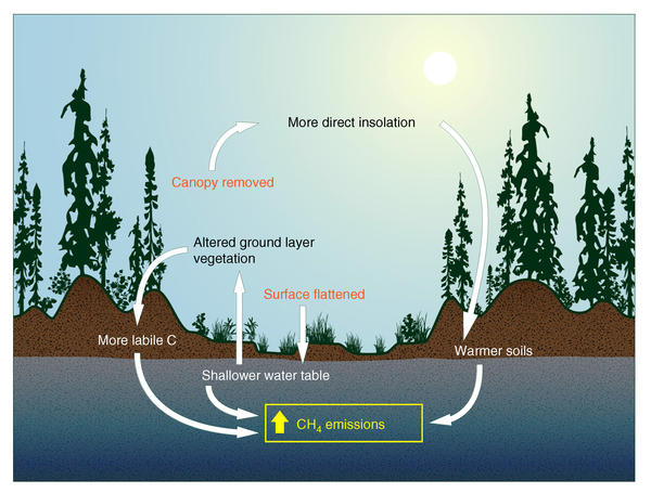
FIGURE 1: Conceptual model of methane flux on peatland seismic lines.
Methodology
The Alberta Merged Wetland Inventory provided a dataset with five basic wetland classes: bog, fen, swamp, marsh and open water. Bog, fen, and swamp were considered as peatland. The Alberta Biodiversity Monitoring Institute’s Wall-to-Wall Human Footprint Inventory database provided seismic line data. The above two datasets were intersected to identify the different types of seismic lines, in particular the older, legacy lines and newer low impact lines, that fall within each class of wetland.
Methane data were compiled from existing studies for Western Canada for fens and bogs, and all of Canada for swamps, given data limitations for this wetland type. In all cases, fluxes needed to be measured at least monthly in the summer period (May–August) and water table data had to be reported in order for an existing study on methane fluxes to be included in the database.
A methane flux-water table regression equation was estimated for each peatland class. Using the estimated mean summer water table position and the results from the estimated regression equation, the mean methane flux for each peatland type was calculated, and converted into an estimate of annual emissions. We then moved the mean water table position closer to the surface of the peatland, as is known to occur on seismic lines, and recalculated the new emission from the area of seismic lines occurring in each peatland class. This then resulted in a new estimated annual peatland methane emission for Alberta.
Outcomes
We estimate that at least 345,000 km of seismic lines and trails cross peatlands in Alberta (Figure 2). Considering the average widths of each disturbance type, the area of peatland disturbed by seismic lines and trails in Alberta is over 1,900 km2. This is most likely an underestimation of the true amount of disturbance, as the inventory mapping protocol likely misses many small disturbances.
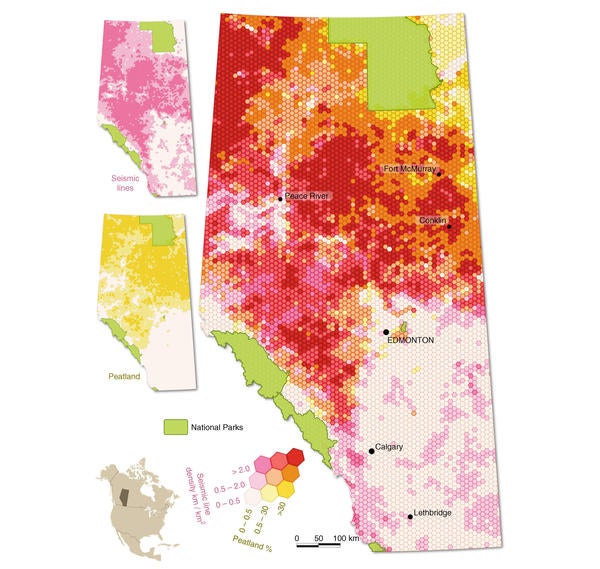
FIGURE 2: Peatland and seismic line density
Regression equations between methane flux and water table positions were statistically significant for each peatland type. Based on the database of peatland methane flux and water table, we determined a mean water table position of −18, −8, and −22 cm for undisturbed swamps, fens, and bogs, respectively, leading to estimated mean emissions of 1.4, 7.1, and 2.5 g methane m−2. yr−1. Using these mean values, we estimated provincewide methane emissions from peatlands at 251 kt without any disturbance. We estimate that seismic lines increase peatland methane emissions in Alberta by 4.4–5.1 kt yr−1 (Table 1).
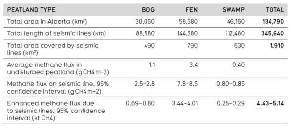
TABLE 1: Summary of peatland and seismic line area and impact on methane emission
Conclusions
We estimated methane emissions from peatland seismic lines over the province of Alberta, Canada. There are very few studies looking at effect of seismic lines on peatland carbon and GHG exchange. Current anthropogenic methane estimates in Canada’s 2016 National GHG Inventory for land use, land use change and forestry sector are 63 kt, so the additional amount estimated in this study is not insignificant and would, if included, increase emissions by 7–8 per cent. As the study only considered hydrological changes, the calculated value likely underestimates enhanced methane emissions and the impact could be much higher if changes to soil temperature and plant community were also considered. Moreover, similar seismic exploration also occurs across large regions of boreal and subarctic North America, and is also widespread in Siberia, a region with abundant peatland cover. Therefore, oil and gas exploration, along with other linear disturbance such as winter roads, may have extensive unreported impacts on peatland methane emissions worldwide.
Given the lack of knowledge regarding the effect of seismic line construction on soil-carbon exchange, there is no specific guidance from the Intergovernmental Panel on Climate Change (IPCC) for estimating GHG emissions caused by this type of land use activity. The Paris Agreement signed in 2016 highlighted the importance of accelerating the reduction of global anthropogenic emissions and recognized the importance of conserving and enhancing sinks and reservoirs of GHGs. Based on our results, we recommend employing a multi-scale approach aimed at determining local factors driving changes in carbon uptake and methane emissions, combined with improved mapping of shifts in ecohydrological conditions over regional scales, in order to better quantify the eff ect of seismic exploration on peatland carbon and GHG exchange.
Strack, M., Hayne, S., Lovitt, J., McDermid, G.J., Rahman, M.M., Saraswati, S., & Xu, B. (2019). Petroleum exploration increases methane emissions from northern peatlands. Nature Communications, 10(2804). doi:10.1038/s41467-019-10762-4.
Contact: Maria Strack, Department of Geography and Environmental Management
For more information about WaterResearch, contact Julie Grant.


