


 When a wetland is directly impacted by human development, we expect its functions, such as habitat provisioning and water retention, to be impaired. The indirect or cumulative effects of these activities may extend beyond the immediate zone of impact to also influence the functioning of neighbouring wetlands, and often go unnoticed and unmitigated.
In Alberta, Canada, the oil sands region encompasses 142,200 km2 of boreal ecosystems. Wetlands encompass approximately 45 per cent of the region, putting them at a high risk for degradation from direct or indirect stressors associated with energy extraction activities or other human development. Since mining companies are only legally bound to reclaim wetlands damaged on their leased lands, but are not accountable for off -lease wetlands indirectly impacted by the activity, this region offers an excellent case study of gaps in wetland protections. In addition, since wetland areas are exposed to a diversity of human development types such as roads, residential development, and agriculture, the cumulative impacts of human development on regional wetlands is not clear, nor is the specific impact of mining activities.
Despite efforts to monitor the impacts of oil sands energy extraction-related activities on wetland ecology, few studies have examined the impacts of diverse human development types on wetland plant communities. This is the first study to examine the cumulative impacts of human development on oil sands wetland vegetation at a regional level.
Methodology
The study focused on the oil sands region within the boreal region of Alberta. A total of 469 wetlands were assessed using vegetation and human footprint data from the Alberta Biodiversity Monitoring Institute. Wetlands are classified as bogs, fens, marshes, wet meadows, or shallow open water wetlands based on soils and vegetation. Of these sites, 146 were classified as “undisturbed” (i.e., no energy and mining development within a 250 m radius), while the other 323 sites had development and were classified as “disturbed”. While all wetlands were used to assess the relative extent of different disturbance types, only disturbed wetlands were used to analyze the impacts of human development on wetland vegetation.
To examine the floristic composition of wetlands, data on vascular plant species occurrence (presence or absence) was assessed. A coefficient of conservatism (C-score), which reflects a species' sensitivity to environmental disturbance, was assigned to each species based on the literature. C-scores range from 0 to 10, where species assigned high C-scores are highly sensitive to any change in environmental condition, while species with low C-scores are tolerant of environmental perturbations. A median C-score for each site was calculated for further use in the statistical analysis.
To compare the extent of energy and mining development within the vicinity of wetlands relative to other forms of anthropogenic development, the total and relative area covered by each development category was calculated within each wetland class. For each wetland class, groups of wetlands supporting similar vascular plant communities were furthermore identified using hierarchical clustering. The impacts of total anthropogenic development and energy and mining development on vegetation communities was then assessed in three ways. First, the total degree of development among groups in each wetland class was compared using Kruskal-Wallis and Dunn tests. Second, linear regressions were used to evaluate the relationship between site-level total development area and C-scores across all groups in each wetland class. Third, vector fitting was used with nonmetric multidimensional scaling ordinations to evaluate the correlation of each development category with important gradients in vascular plant community composition in each wetland class.
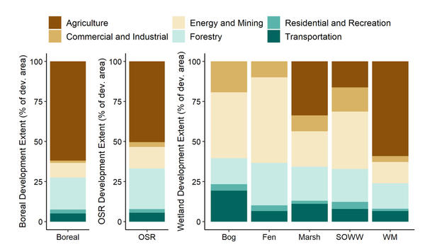
FIGURE 1: The proportion of total development attributable to development categories across Alberta's boreal natural region and the oil sands region. SOWW are shallow open water and WM are wet meadows.
Outcomes
Across the region, we found that total development and the development related to energy and mining were both low, with about 80 per cent of the study area being undeveloped. In disturbed wetlands, the contribution of different development categories to total human development varied substantially across wetland classes (Figure 1).
The analysis identified two distinct floristic groups characteristic of fens, three distinct groups for marshes and wet meadows, and four distinct groups for bogs and shallow open water wetlands. While common species sometimes overlapped across groups within a wetland class, each distinct group was characterized by at least one significant indicator species that differentiated it from the other groups within that wetland class. Floristic groups in wetlands differed in their extents of total plot-level development. Only groups within bogs and fens differed in the extent of energy and mining development (Figure 2).
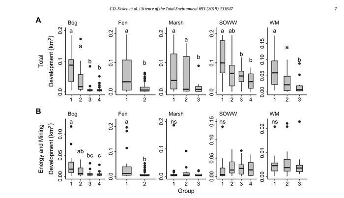
FIGURE 2: (A) Total and (B) energy and mining development within the sites of each distinct floristic group in each wetland class. Center lines in boxplots indicate the median areas; boxes extend to the 25th and 75th area percentiles; whiskers extend to 1.5 times the interquartile range. Significant (p < 0.05) differences among wetland groups are indicated with different lower-case letters. Dunn Tests were not performed if the Kruskal-Wallis test was not significant, and these panels are marked with “ns”.
Despite the low spatial extent, total anthropogenic development was negatively correlated with site-level conservatism in all five wetland classes examined (Figure 3). This suggests that wetlands surrounded by human development are inhabited by generalist species that are tolerant of environmental disturbance. Moreover, distinct floristic groups within each wetland class could be distinguished based on their total developed area, providing additional evidence that human development affects plant composition and diversity, despite its limited extent in the study area.
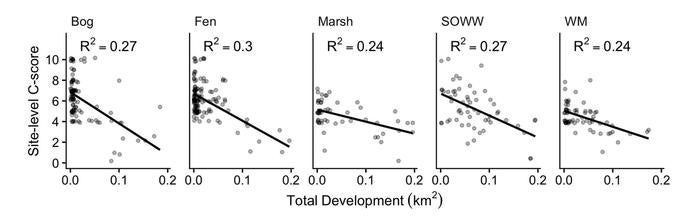
FIGURE 3: Site-level conservatism is negatively related to total development area in all wetland classes examined.
In contrast to total development, energy and mining development had an inconsistent or no detectable impact on wetland plant community composition at the regional level. This is likely because, although intensive, oil sands surface mining is spatially restricted to a small area within the oil sands region.
Conclusions
In this assessment of regional wetland plant diversity and human development we found causes for concern and reassurance. We found that wetlands across the oil sands region in Alberta were still largely isolated from the direct impacts of human development due to the restricted spatial extent of high development areas. This suggests that, apart from wetlands in areas exposed to intensive oil sands surface mining, wetlands in the oil sands region are surrounded by relatively undeveloped land. Despite this, however, we found a distinct and negative signal of total development on wetland flora across the region. This underscores the sensitivity of wetland vegetation to the impacts of human development taking place in the region.
Our results also suggest that no single industry or activity type is solely responsible for observed degradation of wetland floristic composition, so additional research on the impacts of diverse development types on wetland ecology is needed. Since any individual development type was usually accompanied by other development types, the cumulative effect of mixed development types also requires further study.
Ficken, C.D., Cobbaert, D. & Rooney, R.C. (2019). Low extent but high impact of human land use on wetland flora across the boreal oil sands region. Science of the Total Environment (693), doi.org/10.1016/j.scitotenv.2019.133647.
Contact: Rebecca Rooney, Department of Biology
For more information about WaterResearch, contact Julie Grant.


