


Flood regimes are expected to change as a result of the impacts of climate change. It is clear from the literature that observed and projected changes in flood regimes are complex and require a multifaceted approach to characterize the types of changes that have occurred and are likely to occur in the future. This is particularly true of flood regimes in cold regions where the concern is not just with changes in flood magnitudes but also with the timing and frequency of flood events and the dominant flood generating process for a catchment.
Changes in flood regimes can occur as a result of climate change or anthropogenic changes to the contributing watershed. This research seeks to identify changes in flood regimes arising only from climate change, and we explore the following questions: 1) In what ways may climate change alter the flooding regime in cold regions? 2) Has the statistical nature of floods in the study area changed? and 3) Have changes occurred in the nature of the flood regime and the dominant flood generating processes for the catchments?
Methodology
Data were drawn from reference hydrologic networks, with 18 sites in Canada and 9 sites in the United States and included stations with good quality data with nearly 100-year data records. All sites were considered to reflect a cold region flood regime and were screened to avoid the influences of regulation, diversions or land use change.
Peaks over threshold (POT) data were extracted from daily flow data, and changes to the magnitude, timing, frequency, volume and duration of threshold exceedences were investigated. Seasonal statistics were used to explore changes in the nature of the flood regime based on changes in the timing of flood threshold exceedences. A variety of measures were developed to infer flood regime shifts, including from a nival (snowmelt) regime to a mixed regime, and from a mixed regime to a more pluvial- dominated (rainfall) regime.
This work is novel as it examines POT events from a group of reference stations that are suitable for climate-related studies and that have records for close to 100 years. Using our POT data, we were able to examine a much larger number of peak events than studies restricted to the annual maxima series would have allowed. In addition, our work does not restrict itself to only the magnitude of peaks but also considers timing, frequency, duration and volume.
Outcomes
When considering all sites, there are more significant trends than expected for all flooding variables except the maximum and average flood magnitude. The nival stations show significant results for both the maximum magnitude and the occurrence date. The results for the mixed stations collectively suggest a reduced importance of snowmelt, and an increased number of rainfall driven events. In contrast, the pluvial stations exhibit very few trends with the only significant result being for the number of events, which is increasing.
Most of the cases with substantial changes in flood quantiles between the first and last 40 years of data can be explained by the trend strength of one or more of the flood variables, generally either the maximum magnitude, the average magnitude or the number of over threshold events.
The effects of three climate indices on the six flood variables were further explored using composite analysis. There are generally few cases where there is both a significant difference in the flood variable related to a climate index phase and a trend in the flood variable for a station.
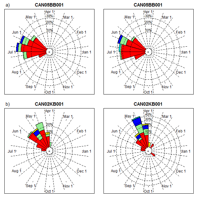
Figure 1: Flood rose diagrams for two nival sites, (a) CAN05BB001 and (b) CAN02KB001. Left plots are for the first 40 years of data and right plots are for the last 40 years of data. Magnitude bins from smallest (center) to largest (periphery) are red, light green, blue, yellow and cyan.
Flood rose diagrams were used to investigate flood regime shifts. Figure 1a shows the results for a mountainous nival station (CAN05BB001) that
displays very similar flood characteristics for the early and late time periods. Most of the mountainous nival stations exhibit similar timing of flood events, with some evidence for larger magnitudes in the more recent period. The results in Figure 1b are for a non-mountainous nival station (CAN02KB001) and provide evidence in support of a shift toward earlier flood events and an increased number of larger events in the recent 40 year period. Rose diagrams for mixed watersheds show clear evidence for earlier snowmelt events and for more flood events that are not part of the spring freshet.
Figure 2a shows the results for a west coast pluvial site (US15072000) that indicate no change in flood characteristics between the early and the late period. Figure 2b displays results for an east coast pluvial site (CAN01EO001) that displays a flood response that is more consistent with a mixed site for the early part of the record, while the later period is more consistent with a pluvial site. This response is characteristic of many of the east coast pluvial sites for which the importance of the snowmelt contribution has diminished over time.
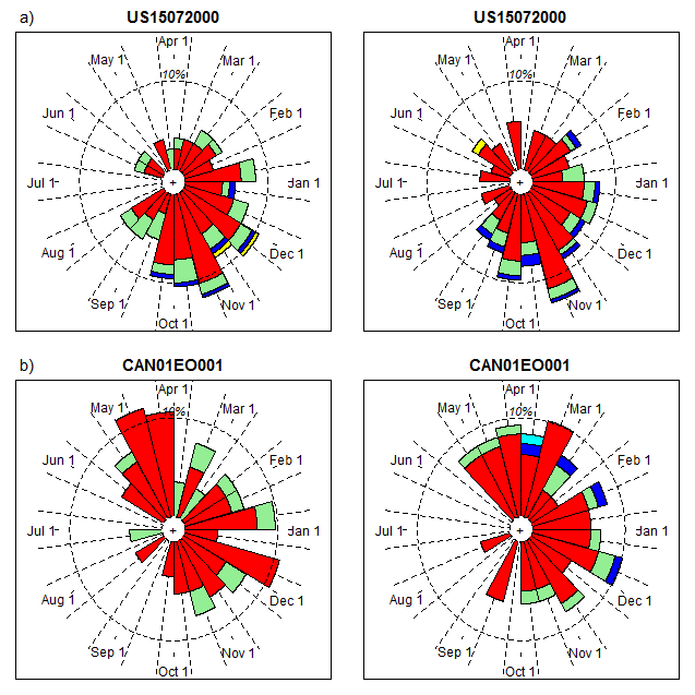
Figure 2: Flood rose diagrams for two pluvial sites, (a) US15072000 and (b) CAN01EO001. Left plots are for the first 40 years of data and right plots are for the last 40 years of data. Magnitude bins from smallest (center) to largest (periphery) are red, light green, blue, yellow and cyan.
Conclusions
In this work, changes to the flood regime were different for different hydrologic regimes. Nival watersheds showed increasing flood magnitudes and larger flood quantile estimates for the most recent period, mixed watersheds experienced an increase in the number of over threshold events and changes in the mean flood date as more events occur in the non-snowmelt season in the later part of the record, and pluvial watersheds, while experiencing fewer changes than the other regimes, did exhibit an increase in the number of over threshold events.
The flood regime at many of the subject watersheds demonstrates an increased prevalence of rainfall flood responses, especially for watersheds with a mixed hydrologic regime. We provide evidence to support a transition of several of the watersheds from a nival response to a more mixed regime and for mixed stations to transition toward a more pluvial response. The results support viewing hydrologic regime as a continuum from nival to pluvial with several stations demonstrating a move toward the pluvial end of this continuum. Flood quantile estimates were observed to be related to the phases of climate indicies; this outcome should be explored in future work.
This paper provides important insights into the nature of changes in flood regime that can be expected within cold regions and challenges the notion that climate change uniformly results in increased flood magnitudes. The complex changes to flood attributes identified in this work can be inferred to be climate-driven since all data are from reference networks.
Burn, D.H. & Whitfield, P.H. (2017). Changes in cold region flood regimes inferred from long-record reference gauging stations. Water Resources Research. 53, 2643-2658.
Contact: Donald Burn, Department of Civil and Environmental Engineering
For more information about WaterResearch, contact Amy Geddes.


