


Surface mining in the Athabasca Oil Sands Region in the western boreal zone of Canada has significantly disturbed the hydrology and ecology of the vegetation and soils. Legally, the disturbed lands must be reclaimed upon mine closure and returned to a naturally appearing and self-sustaining state representative of pre-disturbance conditions. Understanding of hydrologic connectivity (HC) – the water-mediated transport of matter, energy and organisms within or between elements of the hydrologic cycle – and its controlling mechanisms is key to successful reclamation in this region because any disruption to HC will impact the recovery of ecosystem productivity.
This research analyses the impact of climate change and surface mining activities on the HC of surficial (soil and geological) layers located in a watershed in the Athabasca Oil Sands Region. The work is novel in that it specifically analyzes the effect of climate change on HC using an integrated groundwater-surface water numerical model.
Methodology
We studied a watershed north of Fort McMurray in Alberta, Canada, which drains an area of 9,500 km2 into the northern part of the Lower Athabasca Region. The watershed encompasses the vast majority of open pit oil sands mine activity in Alberta and is situated in a mosaic of wetlands, forest and open water.
We simulated the surface and groundwater flows and their interactions area using the GSFLOW model. Surface topography, surficial and geological layer types and thicknesses, surface coverage and daily climate data were used as inputs to GSFLOW and organized using a 2-kilometre grid comprising 2,388 cells, whereby each cell acted as a hydrological response unit (HRU). HRUs are the smallest computational units in the model and were assigned different hydrologic and physical characteristics based on land cover type (wetland, forestland or open water).
Surface water and groundwater flows were simulated for the period 2014-80 under four climate scenarios: median, double precipitation, no-change in precipitation and double temperature (Schneider, 2013). The median scenario had a ~6 mm increase in precipitation and a ~6 oC increase in min and max temperatures; the double precipitation scenario had a ~14 mm increase in precipitation; the double temperature scenario had an increase in min and max temperatures of ~8 oC and an increase in precipitation of ~ 2 mm. The simulations assumed that the extent of mine activities would remain constant after 2013, because the growth in mine footprint is dependent on socio-economic and political factors outside our study scope.
Our approach involved two important innovations. First, our model made use of more realistic precipitation inputs generated by Markov Random Space instead of mean precipitation intensity. Second, we used cascade routing to assess the influence of postglacial landform microtopography on HC.
Outcomes
The duration of the annual growing season will be longer and snowmelt will happen earlier in the year 2080. During the growing season, the daily proportion of connected hydrologic units remains approximately the same in the future under the different climate scenarios. It appears that around 68% of the watershed area will be frequently connected in the future and will remain hydrologically connected for more than 20–50% of the year (Fig. 1).
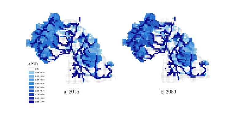
Figure 1: Annual proportion of connected days in different HRUs in 2016 and 2080 for the median (M) change scenario
Mining areas are located in infrequently connected areas. Connected hydrologic units in forestlands are more stable with a growing season that is about 15 days longer than in wetlands.
Comparisons between hydrologic responses in 2016 and 2080 show that, in 2080, maximum snow depths are about 0.7 times smaller, evapotranspiration is about 0.05 mm higher, capillary soil moisture in “double temperature” and “no change in precipitation” scenarios are 1.01–1.52 mm lower, and the ratio of precipitation to potential evapotranspiration is almost the same during the growing season. However, at the end of growing season, the ratio is about 1 unit less in 2080 in “double temperature” and “no change in precipitation” scenarios.
Thinner surficial geological layers in the mining areas (located mostly in the bottom of the watershed) lead to their lower hydrologic connectivity. These areas, therefore, are more vulnerable to mining activity impacts.
Conclusions
Climate change has a greater influence on the duration of HC than on its spatial distribution. The spatial and temporal distribution of HC is not significantly sensitive to changes in the soil moisture threshold. We interpret this to mean that HC at the watershed scale is controlled by other parameters (e.g. hydraulic conductivity of the soil and surficial geology layers or watershed size).
Our results are in agreement with other Canadian models that considered the extremes in temperature and precipitation in their predictions; however, our scenario generations are based on mean changes in precipitation and temperature. Our predictions of an earlier snowmelt season, increase in stream flow in the early growing season, increase in the length of the growing season, decrease in the depth of the snow pack, and a decrease in length of the snow season are in general agreement with previous studies conducted elsewhere in Canada. Yet, given the comparably smaller size of our study area and spatial variability of climate parameters, our results differ from some other Canadian models, in terms of the predicted decrease in streamflow rate in summer and fall.
In areas where more permeable surficial geological layers are limited by fine-grained and impermeable deeper geological layers, areas with thicker surficial geological layers will exhibit greater HC. Also,
in forestlands with thicker surficial geological layers, HC is more stable and lasted for longer annual durations than in wetlands where surficial geological layers were typically thinner. Although the mining areas are located in downstream parts of the watershed and expected to be supplied by upstream areas, their thinner surficial geological layers made them infrequently connected and more vulnerable to the impacts of mining activities. Our results about the effect of surficial geological layer thickness on HC can provide decision makers with new information that may help them understand and manage the potential response of watershed HC to climate change and mining activities, and to inform future reclamation planning.
Kompanizare, M., Petrone, R.M., Shafii, M., Robinson, D.T., Rooney, R.C. (2018) Effect of climate change and mining on hydrological connectivity of surficial layers in the Athabasca Oil Sands Region. Hydrological Processes. 32(25), 3698-3716.
Additional reading
Schneider, R.R. (2013) Alberta’s natural subregions under a changing climate: Past, present and future, Prepared for Biodiversity Management and Climate Change Adaptation Project.
Contact: Rebecca Rooney, Department of Biology


