


Introduction
Civilizations in sub-Saharan Africa, Asia, and Latin America have thrived in environments with large climatic variability by implementing traditional rainwater harvesting and groundwater extraction technologies. The small and fragmented nature of rainwater harvesting reservoirs makes their wide-area monitoring challenging, though with volume estimates subject to large uncertainties. Traditionally, the reservoir surface-water storage has been estimated using in situ water levels calibrated to bathymetric maps. However, this approach is challenging over wide areas, particularly in regions where hydrological stations are unavailable. Therefore, the estimation of water volume in small fragmented systems remains an elusive goal.
The purpose of this study is to show how multi-temporal, multi-sensor (optical and radar) remotely sensed observations of water can be combined with the TanDEM-X Digital Elevation Model (DEM) to estimate surface water storage in rainwater harvesting structures during cloudy conditions in a data-scarce semi-arid environment of southern India.
Methodology
The Gundar River Basin in the southern Indian state of Tamil Nadu was selected for the study (Figure 1). The region is dominated by a tropical monsoon climate and contains hundreds of tanks developed over 2,000 years ago to capture surface runoff and rainfall. Of the 5,647 km2 total study area, 2,314 tanks cover nine per cent of the basin area. From the total number of tanks, active tanks were identified and downsized to generate a calibration dataset. A sample of 72 tanks was created by clustering the total population of tanks into four size groups and taking a proportional sample of suitable tanks from each group.
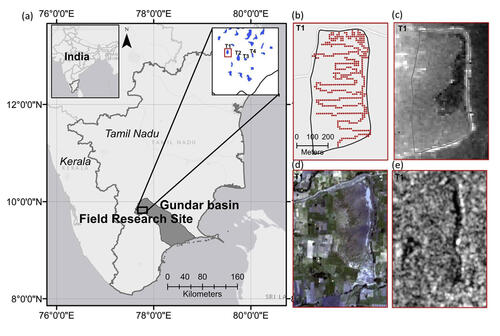
FIGURE 1: (a) The location of the study area. The right inset shows tanks across the landscape with field surveyed tanks labelled T1-T4 and T1 shown in the red box in (a). (b–e) Examples of key datasets for T1: (b) Field GPS 228 elevation points, (c) TanDEM-X DEM, (d) PlanetScope imagery, (e) Sentinel-1A imagery.
The study was based on three types of data: visible infrared and synthetic aperture radar data for surface area estimation, and DEM for topography. TanDEM-X DEM data were used to generate empirical volume- area relationships, and synthetic aperture radar images from Sentinel-1A were used for calculating the reservoir surface water area at the basin scale. Volume-area relationships were validated using field global positioning system (GPS) elevation measurements and Sentinel-1A surface water extents were validated using high- resolution PlanetScope data (Figure 1). For dense time-series volume estimation of a single reservoir, multi-sensor surface area estimates from Sentinel 1-A, PlanetScope, Landsat-8, and Sentinel-2A were used.
Figure 2 shows the methodological steps used in the study which included two phases: (i) a calibration phase, which included the generation of the volume-area relationships and the extraction of surface water area, both of which were used to provide satellite-derived reservoir volume estimates; and (ii) two monitoring application cases.
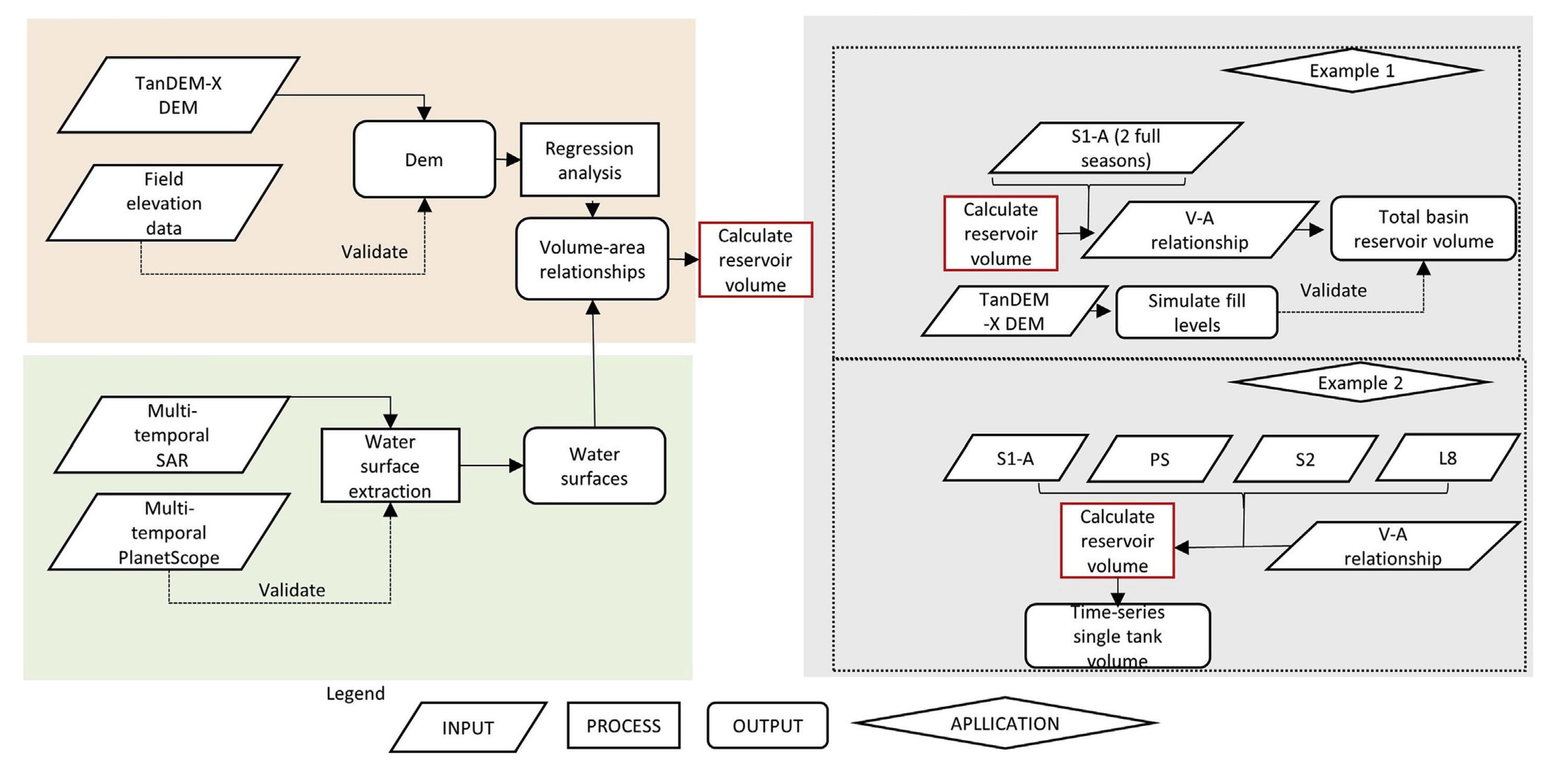
FIGURE 2: Flowchart of the main methodological steps.
Outcomes
The accuracy, profiles of bathymetric information for shape reproduction, and the volume-area relationships derived from TanDEM-X DEM and field survey datasets were evaluated. Strong agreement between the field data and the TanDEM-X elevations support the use of TanDEM-X DEM for estimating bathymetry in-tank structures (Figure 3).
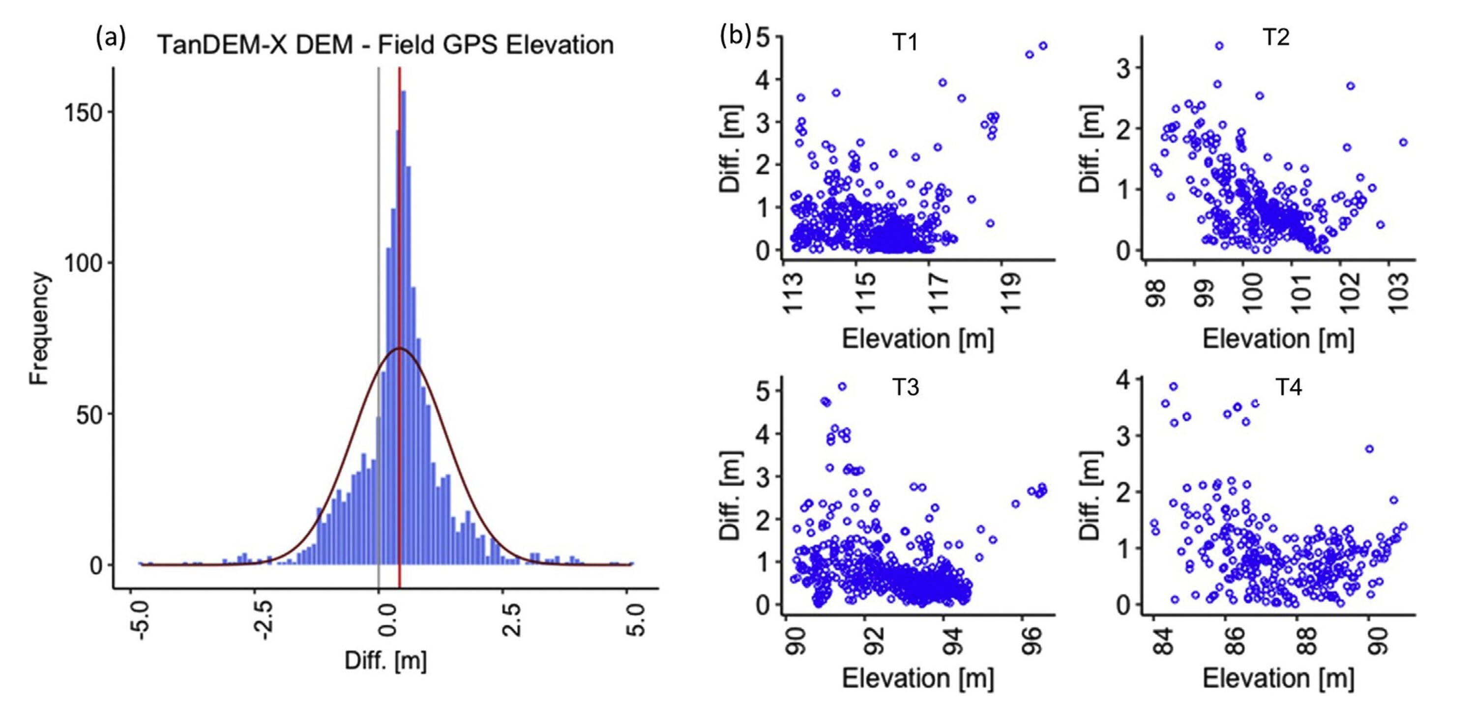
FIGURE 3: (a) Histogram of height differences for TanDEM-X DEM minus GPS points and (b) Height differences between TanDEM-X DEM and GPS points plotted to reference GPS elevation for surveyed Tanks 1–4 (labelled T1-T4 in (b) with their location shown in Figure 1(a)).
Based on the proportional sample of 72 tanks, tank morphometry was representative of various shapes and sizes of tanks that are present in southern India. A strong correlation of 0.98 was observed between the scaling and growth/decay parameters in the generalized equation to estimate the reservoir volume, indicating that the volume-area power relationships developed for the basin are generally applicable. Using the TanDEM-X DEM bathymetry, volume- area relationships for the 72 reservoirs were modelled for low to no water conditions as verified from the field GPS data. Despite the variety of reservoir sizes, the generalized equation for the 72 tanks fitted the observed model with an overall R2 of 95 per cent.
Although the TanDEM-X DEM provides full spatial coverage, it was impossible to obtain the reservoir bottom topographies for many tanks in the study area because of dense vegetation presence in reservoir beds that limit error-free estimates. As a compromise, volume-area power relationships and radar and optical-delineated surface water areas were proposed. Prior to this research, there was no remote sensing-based method to estimate tank storage in this region during monsoon periods: this is now possible with power-law expressions and with estimated volume uncertainties. The application of the volume-area relationship method revealed that at water levels below 1.5 metres, volumes can be estimated within an absolute volume error range of six to eight per cent.
The evaluation of the suitability of Sentinel-1A for surface water extent retrieval suggests that synthetic aperture radar observations are suitable under some conditions, but are often challenging given the large variety in tank geometry and the complexity of radar surface interactions. Thus, when implementing Sentinel-1A only for tank monitoring, a subset of tanks will be omitted or surface water extent underestimated, leading to total tank volumes being underestimated. The incorporation of a shape metric to eliminate surface water areas that are too narrow to be accurately detected is suggested to improve the accuracy of this method. However, when all satellite observing system data are combined (PlanetScope, Landsat 8, Sentinel 1 and 2), it is possible to estimate tank volume dynamics from peak monsoon water levels in September to complete drainage in January (Figure 4).
The two application examples in this study demonstrated the ability to monitor tank volumes with volume-area relationships and multi-sensor surface water estimates. The enhanced global TanDEM-X DEM along with high frequency and accurate surface water observations from CubeSats, provide the ability for a more comprehensive hydrological analysis based on remote sensing observations.
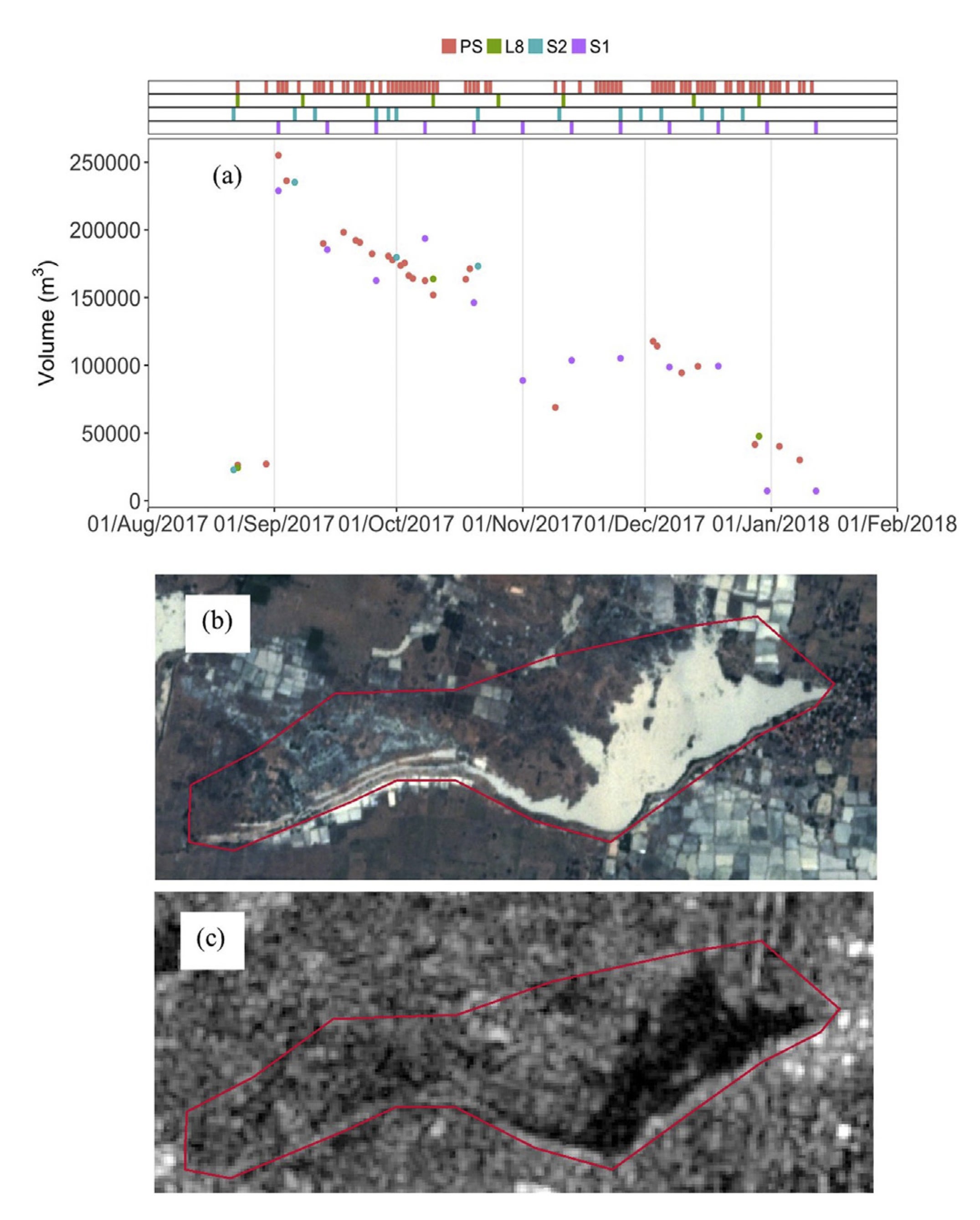
FIGURE 4: (a) Time-series of volume estimates acquired from PS, L8, S2-A, and S1-A, top bars show all available acquisition dates while the dots for each sensor show only the volume retrieved from cloud-free observations. (b–c) show (b) PS TCC image and (c) S1-A VV polarized image during peak surface water extent and volume in the season (see Sept 2, 2017, in plot a).
Conclusions
This study illustrated the applicability and challenges of using satellite-based remote sensing observations to continuously monitor reservoir surface water storage in India’s tank systems. More specifically, the study demonstrated remote sensing techniques for tank monitoring that provide an opportunity to better understand the dominant hydrologic controls governing reservoir outflow and inflows. Furthermore, a methodology was developed to monitor and quantify water volume in tanks under all weather conditions, using Sentinel 1-A observations and high-resolution PlanetScope data.
The study results, which couple empirical volume-area models and remotely sensed surface water area estimates, are a promising first step and proof-of-concept toward predicting ungauged flows in tanks. Remotely sensed observations of tank volumes could assist stakeholders in making more informed water management decisions in tank-based systems. Since small irrigation structures are not continuously monitored, the findings represent a unique contribution to the hydrologic science community.
Contact
 Richard Kelly, Department of Geography and Environmental Management
 Vicky Vanthof, Department of Geography and Environmental Management


Vanthof, V. & Kelly, R. (2019). Water storage estimation in ungauged small reservoirs with the TanDEM-X DEM and multi-source satellite observations. Remote Sensing of Environment, 235. doi.org/10.1016/j.rse.2019.111437
For more information about WaterResearch, contact Julie Grant.


