


Introduction
Hydrologic models require meteorological input data like precipitation and temperature to forecast future conditions, such as river discharge or reservoir storage. These input data, or numerical weather predictions (NWPs), are usually made available by the agency producing them, such as the European Centre for Medium-Range Weather Forecasts (ECMWF), the National Oceanic and Atmospheric Administration (NOAA) of the U.S. Department of Commerce, and Environment and Climate Change Canada (ECCC).
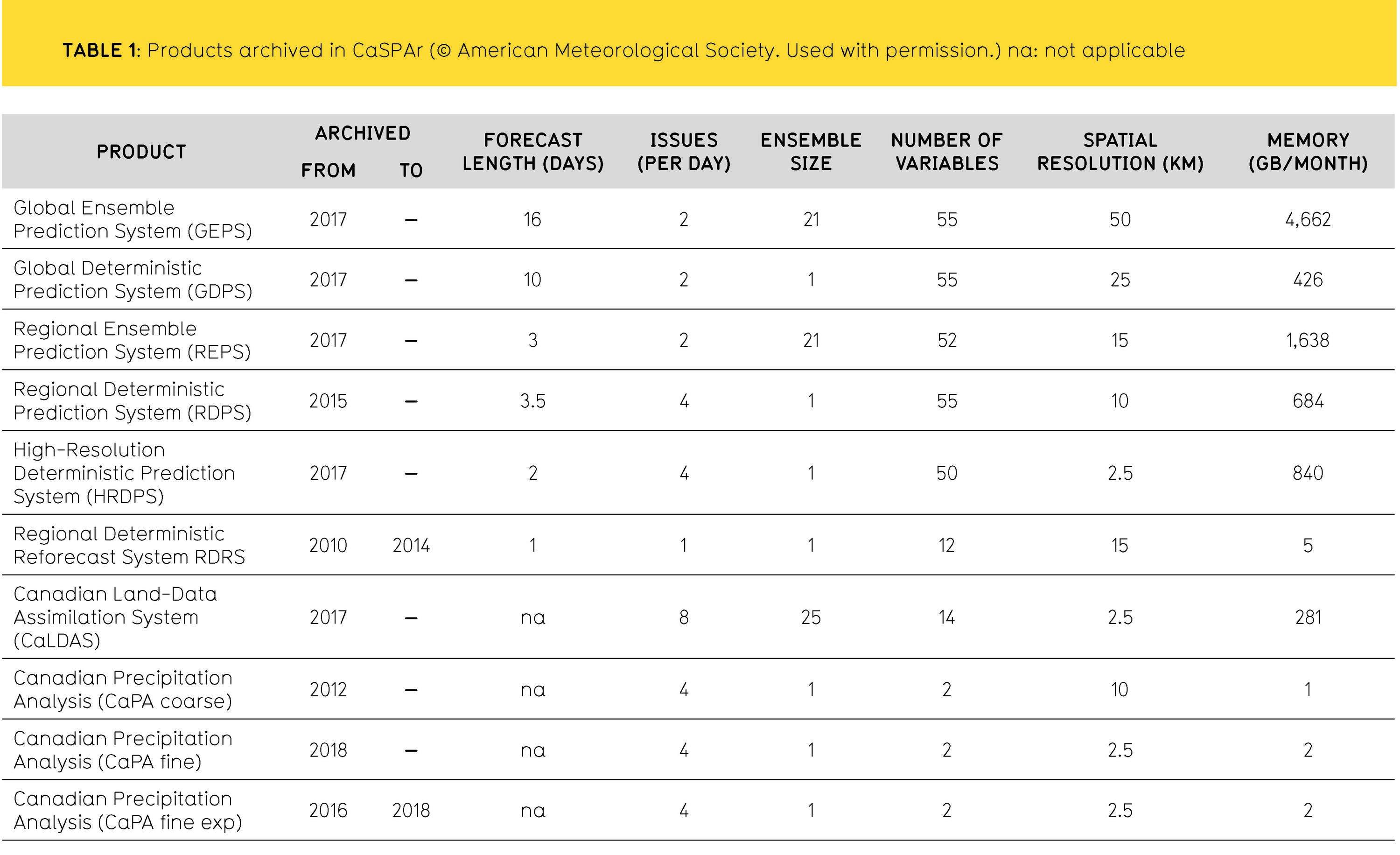
Launched in 2017, the Canadian Surface Prediction Archive (CaSPAr at www.caspar-data.ca) is a collection of NWPs issued by ECCC, and is the only place where ECCC forecasts, analyses and re-analyses can be accessed publicly and in their original native resolution. The CaSPAr is free-of-charge and includes various operational NWPs at an hourly to daily temporal resolution, and a 2.5 km to 50 km spatial resolution. CaSPAr provides a web-based GIS platform that allows the user to select variables, time periods and forecast horizons of interest, as well as spatial sub-setting of the products. A core philosophy of CaSPAr is user data sovereignty, meaning that users determine how their data should be represented for their unique modelling and analysis needs.
This research performed a number of tests to benchmark the processing times and storage sizes associated with various CaSPAr data requests. We also demonstrate how CaSPAr data can be employed to analyze extreme rainfall events using a record flood event for southern Ontario, Canada that occurred in June 2017 to visualize the various precipitation forecasts available.
Methodology
To benchmark the runtimes and storage requirements of potential user-specific data requests of different complexity, the study processed 216 CaSPAr test requests for nine available products against six domains of interest, and the following four scenarios:
- Scenario A: 1 day, 1 horizon, 1 variable, 1 issue
- Scenario B: 1 day, all horizons, 1 variable, 1 issue
- Scenario C: 30 days, all horizons, 1 variable, 1 issue
- Scenario D: 30 days, all horizons, all variables, 1 issue
CaSPAr currently archives five operational forecasts (GEPS, GDPS, REPS, RDPS, and HRDPS), one reanalysis product (RDRS), three operational analyses (CaLDAS, CaPA coarse and fine), and one pre-operational analysis (CaPA fine exp) (Table 1).
 On June 23, 2017, an extreme rainfall event was recorded in the Grand River watershed in Ontario, Canada. As reported by the Grand River Conservation Authority, the local flood forecasting authority, some watershed rain gauges indicated that this was the highest recorded one-day total rainfall since record-keeping began in 1950 with total, two-day precipitation exceeding 130 mm at several stations. While the CaSPAr data was not available to the Authority given its seven-day time delay, the archive shows which data would have been available and allowed for a detailed post-event analysis of various ECCC precipitation products. As such, CaSPAr data for the West Montrose gauge station in the Grand River watershed, where the most severe rainfall was reported, was collected for the post-event analysis.
Outcomes
Figure 1 shows runtime and storage requirement benchmark test results for requests submitted to CaSPAr. Requests for the products REPS, GEPS, and HRDPS led to the most storage intense requests, with Scenario D over the Hudson Bay (yellow bars in Figure 1 first column of panels) resulting in the largest storage sizes of 79.7 GB, 60.5 GB, and 66.3 GB, respectively. The processing times (gray bars in Figure 1) were, surprisingly, independent of the size of the domain of interest, with only the processing of requests for the Hudson Bay taking significantly longer, with the average processing time for the largest request scenario D (lightest gray bars in Figure 1) of GEPS at around 37 hours. As the benchmark results show, storage requirements can be up to 80 GB and processing times can range from minutes to multiple days depending on the user request. The detailed benchmark results provide users with a way to estimate and plan for potentially long waiting times and large storage requirements associated with their specific requests.
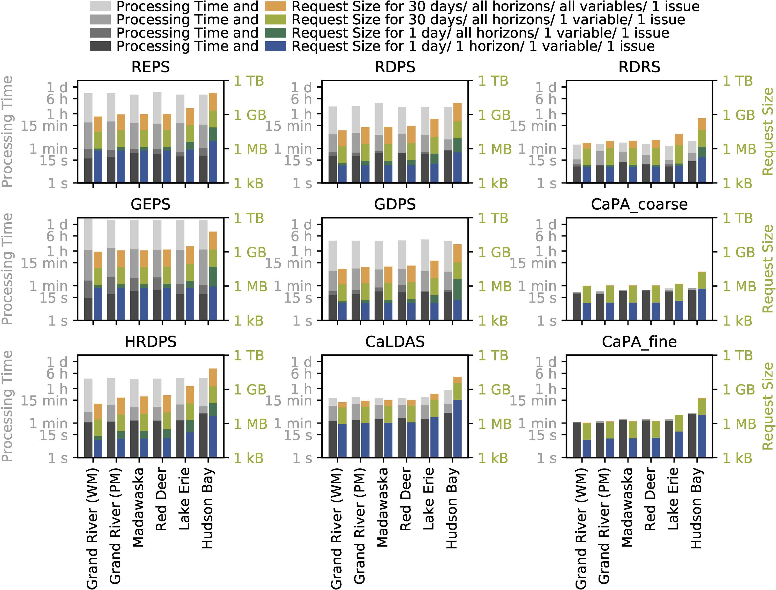
FIGURE 1: Results of benchmark tests for runtime and storage requirements. CPU processing times (gray bars) and required storage (colored bars) for four scenarios at six domains. Since the four request scenarios increase in complexity, the bars are plotted on top of each other. Both y-axes are in logarithmic scale. (©American Meteorological Society. Used with permission.)
The post-event analysis showed that forecasts issued on June 22, 2017 were all predicting a rainfall event, but of lower volume compared to that observed (Figure 2). This is at least partially due to the fact that the study compared peak ground-based total event precipitation observations with average precipitation forecasts for the watershed. Grid cells forecasted with extreme event totals more closely approached the extreme ground-based observation totals for the event with all forecast dates and times (issues) and ensemble members. CaSPAr provides an opportunity for forecasting agencies to test retrospectively alternative ECCC weather forecast products to better understand the strengths and limitations of their current systems and to develop new forecast products.
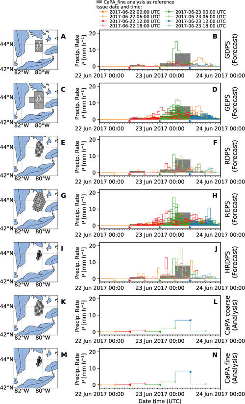
FIGURE 2: Forecasted and observed rainfall amounts at West Montrose, June 22 to 24, 2017 for different forecast products. (©American Meteorological Society. Used with permission.)
Conclusions
The CaSPAr is an archive of ECCC’s NWPs and re-analysis products, and serves as a free platform to communicate and document these products. The archive’s standardized file format makes it easy to compare products, and can also directly, and with minimal effort, be used by a wide range of hydrologic and land-surface models and modelling frameworks. The study found that the degree of customization in CaSPAr is a unique feature relative to other publicly accessible numerical weather prediction archives and that the system minimizes user download requirements and local processing times.
The CaSPAr system fills the void of an accessible archive of the Canadian NWPs and brings them to the same level as NOAA’s NOMADS system and the European NWPs disseminated by the ECMWF. In addition to precipitation and temperature being available in most of the archive’s products, other variables, such as snow depth and density, wind speed and direction, radiation, and humidity, are also accessible. Importantly, the CaSPAr system is the only one of these three systems that allows for spatial cropping and the selection of forecasted horizons, issues, variables and time periods. The system will help practitioners, such as Ontario’s conservation authorities and provincial and local government agencies, to improve their flood forecasting and warning systems and help researchers to test and benchmark new data assimilation techniques and post-processing algorithms.
Contact
 Juliane Mai, Department of Civil and Environmental Engineering
 Bryan Tolson, Department of Civil and Environmental Engineering


Mai, J., Kornelsen, K.C., Tolson, B.A., Fortin, V., Gasset, N., Bouhemhem, D., Schäfer, D., Leahy, M., Anctil, F. (2019). The Canadian Surface Prediction Archive (CaSPAr): A platform to enhance environmental modeling in Canada and globally. Bulletin of the American Meteorological Society. doi 10.1175/BAMS-D-19-0143.1
For more information about WaterResearch, contact Julie Grant.


