Monday, April 29, 2024
 Vicky Situ had her first co-op work term this winter as a GIS Library Technician at the Library’s Geospatial Centre, located in Dana Porter Library. As a second year Geomatics student, she was excited to deepen her GIS skills through the hands-on learning a co-op role provides. What she wasn’t expecting was an opportunity to marry her creativity and love of history with those GIS skills.
The Geospatial Centre has an extensive collection of regional maps, aerial photographs and geospatial data. Beyond Waterloo students and researchers, many local community members access these regional collections for their own projects, from ancestral research to high school and elementary school projects. The slow process of digitizing our collections to provide wider access to our resources is ongoing as need and capacity allows.
Vicky was intrigued by the idea of digitizing a collection of main campus aerial photographs while showing the impact of visual data representation using GIS tools. She decided to use StoryMap, a cloud-based platform that is part of the ArcGIS suite of tools that allows you to transform GIS materials into interactive content that tells a story and is easy to share with others.
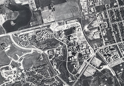
University of Waterloo campus, 1971
As she delved deeper into the project, Vicky completed additional research to provide historical context about what was happening on campus at the time of the photographs. The resulting Campus Progression StoryMap tells the story of campus from before the University was founded through to today using orthoimagery.
“This project was an exciting opportunity for me to put what I’ve learned in class to practical use, try out new tools and leave a lasting impact at the Geospatial Centre,” Vicky shared when reflecting on creating the StoryMap. This term as the GIS Library Technician affirmed her interest in working more with people and urban settings in the future.
The Library provides the UWaterloo campus community access to ArcGIS. If you have an interest in using these tools to support your scholarship and research, the Library also provides GIS instruction and research support. You can explore the Geospatial Centre’s collection on the Library website.


