Andrea Minano, PhD Candidate in Geography, is researching how cross-sectoral collaboration in data management could strengthen flood resiliency in Canada. Andrea is interested in reducing and managing the "flood insurance gap" in Canada—a proportion of residential properties that are exposed to flooding and cannot find flood insurance protection.
By accessing flood maps used by the insurance industry, Andrea has been able to detect properties in Canadian cities that may be considered as high-risk of flooding by insurance companies. For these properties, flood insurance could be unavailable or unaffordable.
Interestingly, Andrea has found that many of the properties located in flood zones identified by the insurance industry fall outside of official government flood zones.
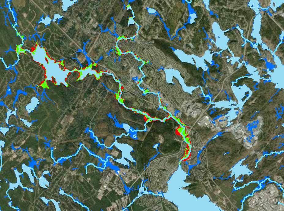
Similarities and differences in insurance and government flood hazards areas for a select neighborhood in Halifax, Nova Scotia.
Data sources: Halifax Open Data and JBA Risk Management (2018). All data has been accessed with permission.
For her next steps, Andrea is developing a data analytics platform that integrates flood mapping data used by the insurance sector and governments to create a holistic view of flood risk. She is currently surveying municipalities across Canada to see if and how having access to flood insurance data could inform municipal flood risk management efforts.
"Perhaps if there is a common view of the problem, it will become easier to drive effective cross-sectoral collaboration and overcome persistent issues with flood insurance."
If you are interested in getting in touch with Andrea to learn more about her research, please email her at aminano@uwaterloo.ca.
References
Minano, Andrea, Jason Thistlethwaite, Daniel Henstra and Daniel Scott. 2021. "Governance of Flood Risk Data: A Comparative Analysis of Government and Insurance Geospatial Data for Identifying Properties at Risk of Flood" Computers, Environment and Urban Systems, 88(1): 1-14.