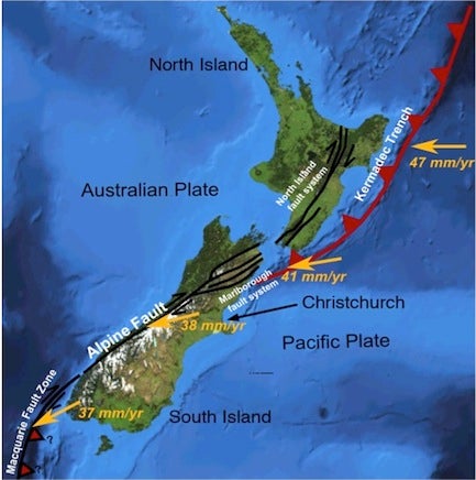
Figure
3:
Major
New
Zealand
faults
(modified
from
Wikipedia).
Due
to
these
plate
movements
there
are
frequent
deep
earthquakes
in
the
north
and
southwest,
were
subduction
is
occurring,
and
shallow
earthquakes
along
the
Alpine
Fault.
Although
the
Christchurch
area
(Canterbury
region)
had
been
stable
for
a
long
time,
there
are
many
faults
underlying
the
area
and
a
1991
report
by
the
government
Earthquake
Commission
concluded
that
earthquakes
as
damaging
as
the
February
22,
2011
event
would
occur
on
average
every
55
years.
The
last
major
earthquake
to
affect
the
region
was
the
1922
Motunau
earthquake.
On
September
4,
2010
Christchurch
was
rocked
by
a
magnitude
7.1
earthquake
centred
38
km
west
of
the
city,
at
a
depth
of
10.5
km.
While
this
quake
caused
a
great
deal
of
damage,
no
lives
were
lost,
partly
because
it
occurred
at
4:35
am,
when
most
people
were
at
home,
partly
because
New
Zealandʼs
strict
building
codes
have
resulted
in
relatively
earthquake-resistant
structures,
and
because
the
quake
was
relatively
distant
from
the
city
and
fairly
deep.
A
magnitude
4.9
aftershock
at
10:30
am
on
December
26
caused
damage
out
of
proportion
to
its
size
because
it
was
shallow,
at
5.12
km
deep,
and
only
2.1
km
from
the
city
centre.
Earthquakes
are
categorized
using
the
Richter
Magnitude
Scale
in
which
each
increase
in
magnitude
means
the
ground
is
shaking
ten
times
as
hard.
For
instance,
a
magnitude
5.0
quake
shakes
ten
times
harder
than
a
magnitude
4.0
tremor.
How
strong
a
quake
feels
at
any
particular
location
is
dependent
not
only
on
the
magnitude,
but
the
distance
from
the
epicentre
(the
surface
location
above
the
focus
of
the
quake)
and
depth
of
the
quake.
Logically
enough,
a
shallow
nearby
tremor
is
worse
than
a
deeper
more
distant
one
of
the
same
magnitude.
The
magnitude
6.3
February
22
earthquake
that
we
experienced
was
centred
6.8
kilometres
from
the
city
centre,
at
a
depth
of
5.9
km.
The
proximity
of
this
quake,
combined
with
the
high
intensity
of
the
ground
movement,
contributed
to
its
destructive
force.
Ground
acceleration
on
February
22
was
measured
as
high
as
2.2
times
the
force
of
gravity
(2.2g),
compared
to
a
high
measured
value
of
1.26g
on
September
4.
Furthermore,
the
ground
motion
was
a
combination
of
up
and
down
and
side
to
side
shaking,
making
it
almost
impossible
for
buildings
to
survive.
Also,
many
buildings
had
already
been
weakened
by
previous
shocks
and
couldnʼt
stand
up
to
any
more
shaking.
The
timing
of
the
quake
contributed
to
the
large
number
of
deaths,
since
it
occurred
during
lunch
hour
on
a
weekday,
when
many
people
were
in
the
central
business
district.
Extensive
damage
was
also
caused
by
liquefaction.
In
this
process,
loose,
saturated
sediment
loses
all
its
strength
and
behaves
like
a
liquid
after
it
receives
a
shock.
Large
areas
of
the
Christchurch
are
underlain
by
this
type
of
sediment,
which
underwent
liquefaction
at
the
time
of
the
September
and
February
quakes,
resulting
in
buildings
being
undermined,
roads
collapsing
and
damage
to
80%
of
the
water
and
sewage
systems.
The
cost
of
post
earthquake
reconstruction
has
been
estimated
at
$12-billion.
With
about
376,000
people,
Christchurch
is
New
Zealandʼs
second
largest
city
and
comprises
about
8.6%
of
the
countryʼs
population.
In
terms
of
the
proportion
of
the
countryʼs
population
affected,
the
Christchurch
earthquake
is
approximately
analogous
to
a
similar
catastrophe
hitting
Toronto.
For
Heather
and
I,
and
the
two
friends
who
took
us
in,
the
loss
of
the
water
infrastructure
was
the
most
immediate
concern.
Electricity
had
been
restored
where
we
were
staying
by
9:00
pm,
but
with
no
drinking
water
and
toilet
facilities
were
a
major
concern.
The
four
of
us
had
a
total
of
three
litres
of
water,
which
wouldnʼt
last
long.
Fortunately
for
us,
it
rained
that
night
and
we
were
able
to
collect
a
barrel
of
clear
rainwater,
which
only
had
to
be
boiled
before
use.
Toilet
facilities
were
more
of
a
challenge,
with
a
hole
in
the
ground
or
a
bucket
filling
the
bill.
It
was
a
lesson
in
how
reliant
we
are
on
city
utilities
to
keep
us
from
regressing
to
a
primitive
lifestyle.
Christchurch
continued
to
be
rocked
by
aftershocks
so,
after
three
days,
we
left
to
stay
with
other
friends
in
the
town
of
Ashburton,
about
90
km
southwest
of
Christchurch.
Ashburton
was
largely
unaffected
by
the
earthquakes
and
had
full
services
and
a
welcome
lack
of
aftershocks.
Because
of
the
hasty
departure
from
our
apartment,
most
of
our
possessions
were
still
there.
Unfortunately,
our
place
was
inside
the
cordon
maintained
by
the
police
and
army
for
public
safety
and,
therefore,
was
off
limits
for
all
but
essential
personnel.
Daily
calls
to
the
police
confirmed
that
no
one
was
being
allowed
in.
By
this
point,
ten
days
after
the
earthquake,
we
were
eager
to
return
to
Canada
so
we
wouldnʼt
be
a
burden
to
our
friends
for
longer
than
absolutely
necessary.
We
had
heard
a
rumor
that
some
people
were
being
allowed
access
to
their
homes
in
the
cordoned-off
area,
so
we
decided
to
take
a
chance.
On
March
4
we
showed
up
at
one
of
the
checkpoints
with
a
phone
bill
to
prove
our
address,
and
our
passports
for
ID,
and,
much
to
our
surprise,
were
allowed
to
go
to
our
place
unescorted
to
retrieve
our
belongings.
Inside
the
cordon
the
city
was
eerily
quiet,
with
few
vehicles
and
many
roads
damaged
by
the
quake.
Abandoned
cars
made
the
place
feel
like
a
ghost
town.
We
reached
our
building
and
found
it
apparently
intact,
and
only
slightly
damaged
but,
half
a
block
away,
Colombo
Street
was
a
scene
of
devastation
that
looked
like
a
war
zone
(Figures
4
and
5).
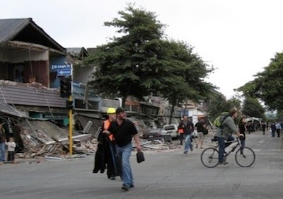
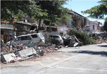
Figure
4:
The
corner
of
Colombo
and
St.
Asaph
streets,
half
a
block
from
our
building.
Our
building
had
a
yellow
sticker,
meaning
it
might
have
been
unsafe
to
enter
(kind
of
like
saying
this
gun
may
be
loaded),
so
we
went
in
with
some
trepidation,
concerned
that
an
aftershock
might
bring
it
down.
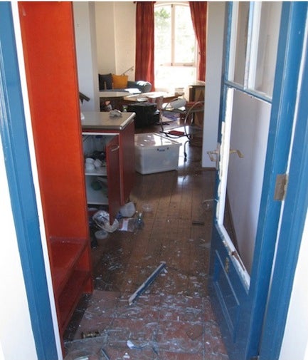
Inside
(Figure
6),
despite
the
fact
that
most
things
had
fallen
off
the
walls,
or
tipped
over,
and
much
of
the
kitchen
ware
had
fallen
out
of
the
cupboards,
the
place
seemed
to
be
structurally
intact,
with
some
cracks
in
the
walls
being
the
only
apparent
damage.
We
hurried
to
remove
our
belongings
from
the
apartment
and
load
them
into
our
rented
SUV,
which
ended
up
stuffed
full
to
the
roof.
As
we
were
finishing,
a
military
vehicle
with
two
soldiers
stopped
to
see
what
we
were
doing.
One
soldier
took
a
look
at
the
yellow
sticker
on
the
building
and
told
us
to
get
out
as
quickly
as
possible.
Once
we
retrieved
our
things
we
were
able
to
rebook
our
airline
tickets,
to
depart
two
weeks
earlier
than
planned.
We
then
took
a
week-long
trip
to
the
north
island,
which
had
been
planned
before
the
earthquake.
We
returned
to
Christchurch
briefly,
then
left
for
Canada
on
March
16.
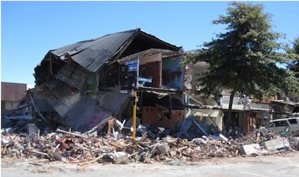
Figure
6:
Our
apartment
after
the
earthquake.
For
Heather
and
I,
our
earthquake
experience
ended
when
the
wheels
of
the
Air
New
Zealand
Boeing
777
left
the
ground
in
Auckland,
bound
for
Vancouver.
But,
for
the
people
of
Christchurch,
the
ramifications
of
the
disaster
continue.
Much
of
the
downtown,
called
the
Red
Zone,
is
still
cordoned
off,
meaning
access
is
limited
for
both
business
and
residents.
No
one
can
live
or
work
in
this
area.
Many
buildings
have
red
stickers,
which
means
they
are
unsafe
and
may
have
to
be
demolished.
Thousands
of
people
are
still
either
homeless,
or
living
in
badly-damaged
houses
that
need
to
be
rebuilt.
After
returning
to
Canada,
we
were
informed
that
our
building
had
been
red
stickered
and
may
have
to
be
partially
demolished,
so
the
permanent
residents,
our
friends,
have
had
to
find
alternate
accommodation
for
the
foreseeable
future.
We
feel
fortunate
to
have
come
through
the
experience
unscathed,
and
that
none
of
our
friends
were
harmed.