Saturday, December 24, 2011
What
on
Earth:
Volume
7
2011
P.F.
Karrow
In
natural
science,
the
frontier
of
the
unknown
is
never
far
away.
One
of
the
frontiers
lies
below
our
feet.
What
lies
below
the
surface
of
the
ground?
How
did
the
University
campus
get
to
be
so
hilly?
In
May,
1976,
a
hole
was
drilled
by
the
Department
of
Earth
Sciences
drilling
rig
beside
the
Chemistry
Building,
in
order
to
get
a
glimpse
into
the
unknown
below
us.
Although
when
the
various
buildings
were
constructed
exposures
and
borings
were
made,
these
generally
extended
to
only
shallow
depths
of
3
to
10
metres
and
deposits
still
farther
down
remained
concealed
and
unknown.
A
few
test
holes
had
also
been
put
down
to
test
water
supplies
but
no
soil
samples
had
been
obtained
from
these
holes.
From
these,
however,
we
estimated
that
the
depth
to
rock
was
about
30
metres
under
the
Chemistry
Building,
and
so
we
made
plans
to
get
a
continuous
core
sampling
of
the
materials
down
into
bedrock.
The
sequence
of
deposits
encountered
in
the
hole
reveals
part
of
the
geological
history
of
the
area.
Together
with
other
available
information,
an
interesting
story
can
be
put
together.
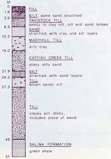
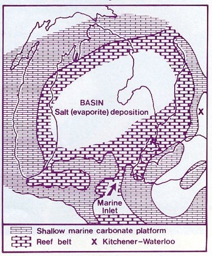
The story of the bedrock
The
solid
rock
encountered
directly
below
the
campus
is
green
shale
and
brown
dolomite
of
the
Salina
Formation.
Southeast
of
us,
near
Paris,
this
same
rock
formation
is
exposed
in
the
banks
of
the
Grand
and
Speed
Rivers.
Paris
got
its
name
from
gypsum
deposits
formerly
mined
from
the
Salina
Formation
(for
“Plaster
of
Paris”).
At
Goderich,
rock
salt
is
obtained
from
the
same
formation.
These
evaporite
minerals
tell
us
that
the
Salina
Formation
was
formed
in
a
shallow
arm
of
the
sea
that
then
covered
much
of
the
eastern
United
States.
The
age
of
these
rocks
is
about
400
million
years.
Green
shale
of
the
Salina
Formation
was
penetrated
for
about
6
metres
by
the
1976
boring.
We
know
from
rocks
laid
down
elsewhere
that
a
long
span
of
time
is
unrecorded
by
the
rock
succession
at
this
location.
Presumably
some
rocks
were
formed,
but
were
later
eroded
away.
The
traces
of
old
stream
valleys
cut
into
the
rock
surface
are
revealed
by
water
well
records,
which
show
that
various
“buried
valleys”,
completely
filled
and
concealed
by
much
younger
glacial
deposits,
cross
the
area.
The
missing
interval
here
spans
the
period
from
400
million
years
ago,
to
several
tens
of
thousands
of
years
ago.
The story of the glacial deposits
The
deposits
overlying
and
concealing
the
bedrock
are
mainly
derived
from
glaciations.
More
specifically,
they
are
a
mixture
of
all
sizes
of
material
from
clay
to
boulders,
called
till,
laid
down
directly
by
the
ice
itself.
The
several
layers
of
different
kinds
of
till
represent
several
advances
of
the
ice
over
the
area.
In
all,
five
till
layers
were
encountered
in
the
borehole,
as
shown
in
the
accompanying
sketch.
At
a
depth
of
about
42
metres,
in
the
lowest
till
layer,
a
small
piece
of
spruce
wood
was
found.
This
tells
us
that
the
ice
which
deposited
the
till
overrode
the
vegetation
which
grew
earlier
in
the
area.
We
don’t
know
the
age
of
the
wood
(it
is
too
small
for
radiocarbon
dating)
but
it
could
be
50,000
to
100,000
years
old.
We
know
that
the
middle
layer
of
till
(Catfish
Creek
Till)
was
laid
down
by
a
strong
ice
advance
about
18,000
years
ago,
which
covered
all
of
Ontario
and
the
northern
States.
Melting
back
about
16,000
years
ago
temporarily
uncovered
this
area,
but
it
was
covered
by
ice
again
about
15,000
years
ago.
About
this
time
melt-waters
from
the
glaciers
were
building
up
large
accumulations
of
gravel
and
sand,
forming
the
Waterloo
sandhills.
We
are
situated
on
the
eastern
edge
of
these
rolling
sandhills
and
fine
sand
of
this
origin
is
found
exposed
in
the
slopes
south
of
Columbia
Street.
Ice
flowing
from
the
Georgian
Bay
area
and
Lake
Ontario
area
both
covered
this
vicinity
one
time
or
another
near
14,000
years
ago
and
then
finally
retreated.
The
next
ice
readvance
from
the
east
only
reached
the
east
edge
of
Waterloo
but
melt-waters
eroded
into
the
older
deposits
and
gave
birth
to
the
various
branches
of
Laurel
Creek.
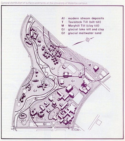
Remnants
of
the
Tavistock
Till
sheet,
brought
here
by
the
last
advance
of
the
Georgian
Bay
ice
are
to
be
found
on
the
tops
of
the
higher
areas
near
St.
Paul’s
College,
along
Columbia
Street
and
at
the
Graduate
House
and
Minota
Hagey
Residence.
Thorough
the
thousands
of
years
following,
the
valleys
have
deepened
as
Laurel
Creek
continued
to
cut
down.
In
some
places
erosion
was
hindered
by
the
glacial
deposits
and
the
streams
became
sluggish
and
swampy.
The
climate
became
warmer,
and
the
spruce
forest
was
succeeded
by
pine
forest,
then
later
by
the
hardwoods.
Erosion
continues
today
along
Laurel
Creek
however.
During
construction
of
the
Village
residences,
disturbed
soil
around
the
excavations
was
washed
into
the
stream
channel
by
heavy
rains.
This
sediment
was
carried
down
to
the
pond
at
Conrad
Grebel
College,
where
it
accumulated
in
a
delta.
As
the
delta
grew
rapidly,
it
had
to
be
dredged
out
several
times
by
dragline
to
prevent
filing
of
the
pond.
With
cessation
of
construction,
and
landscaping,
sediment
load
in
the
stream
has
greatly
diminished
and
a
more
stable
pond
environment
has
resulted.
Further information on the local geology may be gained from the following:
Chapman,
L.J.
and
Putnam,
D.F.,
1966,
The
physiography
of
southern
Ontario;
2nd
edition,
University
of
Toronto
Press.
386
p.
Isherwood,
A.E.,
1976,
Quaternary
geology
and
soil
conditions,
University
of
Waterloo
campus;
M.Sc.
project
report.
Dept.
of
Earth
Sciences.
59p.
Karrow,
P.F.,
1971,
Quaternary
geology
of
the
Stratford-Conestoga
area,
Ontario;
Geol.
Surv.
Can.
Paper
70-34.
11p.