Saturday, December 24, 2011
What on Earth: Volume 7 2011
Kitchener: The Homer Watson Park section
P. F. Karrow
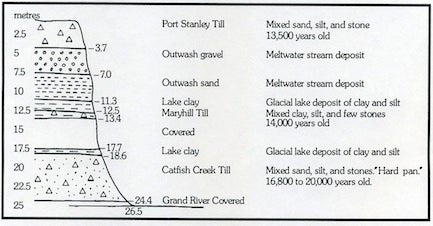
On the west bank of the Grand River, at Homer Watson Park, is an exposure of the subsurface materials which reveals something of the geological history of the Kitchener area. The exposure was created by river bank erosion by the Grand River. From time to time the exposure is covered by slumped material and vegetation, but this varies with river flooding and weather conditions.

The
oldest
deposit
is
at
the
bottom,
near
the
level
of
the
Grand
River.
It
consists
of
a
hard
mixture
of
sand
and
silt
with
many
stones
deposited
by
glacial
ice
and
called
the
Catfish
Creek
Till.
It
was
laid
down
by
the
thickest
ice
to
cover
this
area
about
18,000
years
ago.
At
that
time,
the
glacier
extended
south
into
the
United
States
as
far
as
the
Ohio
River.
Above
that
till
is
some
layered
clay
deposited
in
a
glacial
lake
which
occupied
the
Grand
Valley.
The
glacier
had
melted
back,
but
a
lake
had
formed
here.
Into
the
lake,
the
glacier
advanced
again,
this
time
ploughing
up
the
lake
clay
to
form
a
clayey
till
we
call
the
Maryhill
Till.
This
ice
advance
only
extended
into
the
western
part
of
the
Waterloo
Region
where
it
fluctuated
for
a
few
centuries.
Meltwater
from
the
ice
laid
down
large
masses
of
sand
and
gravel
to
form
the
Waterloo
moraine.
During
ice
retreat
glacial
lakes
again
deposited
layered
clay,
and
meltwater
streamed
formed
the
outwash
deposits
near
the
top
of
the
cliff.
The
final
ice
advance
formed
the
Port
Stanley
Till
and
reached
only
part
way
into
Kitchener
before
melting
away
again
about
13,500
years
ago.
During
this
time,
meltwaters
formed
the
large
gravel
terraces
along
the
Grand
Valley;
as
the
load
of
sand
and
gravel
in
the
meltwaters
lessened,
the
river
cut
down,
becoming
a
slow-moving
meandering
stream
with
a
steel
cut-bank
here
on
the
west
side
which
reveals
the
glacial
history.
Examining
many
of
these
exposures
allows
us
to
build
up
the
geological
history
of
the
district.