Contact the Geospatial Centre
Dana Porter Library, Room 328
University of Waterloo Library
Waterloo, Ontario N2L 3G1
Email: librarygeo@library.uwaterloo.ca
The Geospatial Centre contains more than 55,000 aerial photographs, photomaps, and photomosaics. You will need to use flight indexes and grid indexes to locate specific aerial photographs, photomaps, and photomosaics. This guide will help you use these indexes. Further information and assistance is available from staff at the public services desk.
Printed aerial photographs available in the Geospatial Centre provides a brief description of the photograph, photomap, and photomosaic sets in the collection. Browse through the publication to identify sets which may provide coverage of your area. Record the type of image (aerial photograph, photomap, or photomosaic), date of coverage, geographical area covered, scale, and publisher for any sets of interest. You will need this information to locate the appropriate indexes.
Aerial photograph and photomap indexes are stored in the top drawers of the horizontal map cabinets behind the public services desk. Photograph indexes are filed by year of coverage in the top 2 drawers; photomap indexes are filed in a drawer below them. The index to the photomosaic collection is kept with the mosaics. Each index has a label in the lower right corner to help you identify it. Matching date of coverage and scale is a quick method of identifying the indexes for sets of interest. Note that some indexes are made up of more than 1 sheet. Use the coverage information on the label to determine which index sheet covers your area.
Once you have located your specific area of interest on the index, check the label at the lower right corner of the index for information on coverage available in the Geospatial Centre. The Centre may have all areas on the index or just highlighted sections. If your area is not held by the library, you may be able to obtain a photograph or photomap from a retail source or Interlibrary loan (ILL) . A list of retail sources or information about Interlibrary loan (ILL) is available at the public services desk.
If you have difficulty locating your specific area on the index, it may help to determine the location of your study area on a 1:50,000 scale National Topographic System (NTS) map. The 1:50,000 NTS maps are filed by NTS map number in the vertical map cabinets.
Photograph indexes are based on flight lines. To obtain the index number for your area, follow the line intersecting your area and follow it to the right or left side of the index. A break in the line indicates a different roll number (see the 1978 example below.) Record the line, roll (if given), photograph number, and date of coverage. This information is needed to find a specific photograph in the collection.
Sample entry from a 1978 aerial photograph index:
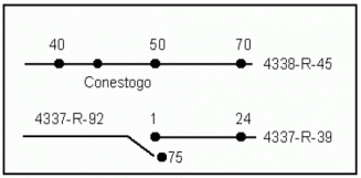
The index number for Conestogo would be:
1978 - date of coverage
4338 - line
R-45 - roll
44 - photo number
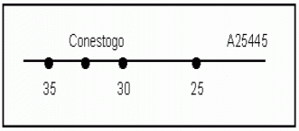
The index number for Conestogo would be:
1980 - date of coverage
A25445 - line
33 - photo number
Photomap and photomosaic indexes are based on either a grid system or individually numbered sheets. The grid or sheet number and year of coverage are needed to find specific sheets in the collection.
Sample entry from a 1990 photomap index:
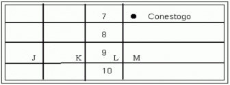
The index number for Conestogo would be:
1990 - date of coverage
7M - grid number
Aerial photographs are filed by year of coverage in the vertical filing cabinets across from the public services desk. Within these cabinets, the photos are contained in file folders organized by flight line number and roll number. Photos earlier than 1960 are kept in locked cabinets; ask at the public services desk for assistance.
The photographs in each folder are listed on the folder's back tab. Pull out the folder containing your photograph. Individual photo numbers are shown on each photo.
Part of the photomap and photomosaic collection is filed in the horizontal map cabinets across from the public services desk. Photomaps and photomosaics are filed in order by grid or sheet number. The rest of the collection is kept in storage. Photomapsets and photomosaics in storage are indicated on the index. To obtain items from storage, ask at the public services desk.
Photographs, photomaps, and photomosaics must be used in the Geospatial Centre. Faculty and graduate students may borrow aerial photographs for 3 days. Images from the archival collection (prior to 1960) and from the reference set (1990) are for use in the library only.
Pocket and mirror stereoscopes are available for use in the library from the public services desk.
Please do not refile any materials. Leave the photographs and file folders on top of the filing cabinets. Photographs from the locked cabinets (1955 and earlier) should be returned to the Public Services Desk. Please leave photomaps, photomosaics, and indexes on top of the map cabinets behind from the public services desk.


