Yep, DIY stands for “Do It Yourself”. And that is exactly what two of my students for Geography 307, at McGill University did to overcome a huge challenge that they were having finding data on vacant land in Detroit, Michigan.
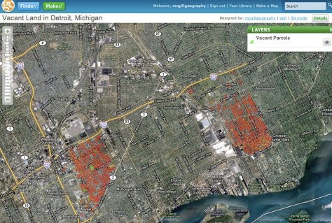
The two students wanted to find out the potential for urban agriculture in the now increasingly vacant residential areas of urban Detroit. Problem was, they couldn’t find any available (i.e. free) data that showed the location of parcels of vacant land. Data provided by Data Driven Detroit (the Detroit Parcel Survey) is interesting, but at too aggregate a level. The only type of maps provided show vacancy rates, not the location of specific vacant properties or large contiguous areas of vacant properties that would be useful for farming. How could they do a project on the potential for urban agriculture without knowing the specific location of clumps of vacant terrain?
The solution: Do It Yourself, with free tools and imagery available in Google Earth.
It is incredibly simple to use Google Earth (both the software itself and the imagery) to digitize vacant land parcels. See an excellent outline of the procedure. Thanks to new Keyhole Markup Language (KML) import/export functions, it is also simple to bring your results into ArcGIS for further analysis.
I think this is an excellent way to generate rights-free data, as well as to bring back some interest in the old skills of airphoto interpretation. I was really impressed with the results my students obtained, with hundreds of parcels being identified. Though this is far from a complete dataset, it provides a visually powerful look at a fascinating urban process.
You can take a look at a map made with this data hosted on Geocommons Maker! The raw data is available for download on Geocommons Finder!