See below for descriptions of current and past research projects. I am looking for highly-motivated students at all levels to join my team! If you are interested in working with me, please read the information for prospective students.
Spatial data sovereignty and evolving spatial data infrastructures (most current project)
Digital maps form a cornerstone of many of the services that we rely on every day. From navigation, to the delivery of goods, to public health decision-making, location data shared in map form are a critical resource. Recent changes to the systems that collect, deploy, and share spatial data have raised questions about the entities that own these resources. Governments are no longer the only collectors of spatial data. Private sector companies are playing significant roles and open source community-driven efforts also collect and provide spatial data. This loss of government sovereignty over spatial data resources creates a policy vacuum with many unknowns. On one hand, this shift has the potential to impact the ability of government to collect and use data to inform decision-making about the allocation of public goods and services. On the other, a diminished role for government could give more space to alternative perspectives on defining the spaces in which we live. The overarching goal of this research is to assess the shifting landscape of spatial data sovereignty and its impacts.
Open data/open government
Within this research theme, I focus on two areas; first, establishing the value of open data and civic hackathons, and second, understanding the role of open data and civic hackathons within open government initiatives. This research will make a significant contribution to the emerging discourse on the use and value of open data, and directly support evolving government open data policies.
Mobile technology and crowdsourcing
Within this research theme, I focus on contributing to academic and applied knowledge of how mobile technology impacts our interactions with space and location. This is a rapidly growing and dynamic area of research, with potential to dramatically increase the amount, frequency, and diversity of data collected from individuals, as well as reinforce societal engagement through the involvement of citizens as contributors to science and government decision-making. The broad impact of this research theme is that as society at large adopts mobile computing, there is a corresponding requirement for research on both the affordances and constraints of this technological ubiquity, particularly from a geospatial perspective.
The Geospatial Web (Geoweb)
Within this theme, I focus on the development and testing of web-based mapping platforms for specific domain areas. Impact from this collective research theme has delivered novel empirical case studies, the development of guidelines for practitioners, and the advancement of theories of digitally-enabled participation
Integrating volunteered geographic information in governance (archived project)

This research project investigates the use of volunteered geographic information (VGI) as a vehicle for citizen engagement in governance. Related to this evaluation, is a focus on the distribution by governments (mostly municipal governments) of Open Data. This area of research will uncover the motivating factors driving government adoption and use of VGI, and the place of Open Data as a conduit for Open Government. This research is embedded within the Geothink partnership and network of researchers.
Participatory Geoweb for visualizing climate change adaptation planning in Nova Scotia (archived project)

The purpose of this research is to develop an innovative stakeholder-based decision support process for community-level planning for climate change in the tourism sector. This research uses new approaches to adaptation planning and develops an innovative tool to create a novel method of data collection, analysis, and synthesis for adaptation planning. A case study of tourism in the Region of Queens Municipality, Nova Scotia will evaluate the potential of combining Scenario-Based Stakeholder Engagement (SBSE) with emerging participatory geospatial technologies and serve as a pilot study for the development of a generalizable protocol and toolkit that can be exported to other jurisdictions and economic sectors. We use Geospatial Web 2.0 (Geoweb) technologies, which have potential for enhancing participatory processes. Geoweb is tested for its ability to foster dialogue among decision-makers, researchers, and stakeholders. The Geoweb allows individuals to interact with and update dynamic on-line maps that synthesize multiple data streams. These maps show future trajectories, can be used to evaluate potential decisions and support action to best mediate harm and seize opportunities associated with climate change. This project is being organized in conjunction with the Partnership for Canadian-Carribbean Community Climate Change Adaptation (ParCa) research initiative.
Geoweb and community development (archived project)
This area of research examines the development of collaborative web-based geospatial technology (the Geoweb). The goals of this project are to establish the value of volunteered geographic information as a data source, determine how the Geoweb can be used to facilitate citizen participation, and evaluate the role of government in supporting or constraining the development of the Geoweb.
An integrated modeling approach to assess regional ski tourism vulnerability to climate change (archived project)
With its highly visible impacts from weather variability, the multi-billion dollar ski industry has been repeatedly identified as vulnerable to ongoing and future climate change. Media in Europe, the U.S., Canada, and elsewhere have declared that climate change could ‘wipe out’ large portions of the ski industry, with severe economic impacts for many rural economies, vacation property real-estate value, sports participation, and regional cultural loss. This research will improve understanding of the risks and opportunities climate change poses for the ski tourism industry in Ontario, providing guidance for business and government adaptation to climate-driven market shifts. The research builds on existing collaborations with the tourism sector to develop a new integrated agent-based systems model of the Ontario ski marketplace that is capable of assessing the simultaneous impact of climate change on ski operators and skier responses to changes in ski conditions and the seasonal availability of ski areas.
TourSim ABM (archived project)
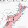
This research developed an agent-based model (ABM) to experiment with tourism development dynamics in the Canadian province of Nova Scotia. A primary finding was that ABM has significant tourism planning potential, as a scenario development, and communication tool. This research has implications for how planners use technology, identifying constraints to the the process of technology adoption. Inactive research project.