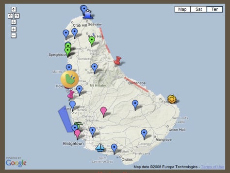
New web-based technologies such as Google Maps (a.k.a. “Geoweb” applications) are changing the ways in which individuals communicate their concerns. This is particularly true in the case of spatial phenomenon, such as instances of environmental change. Britta Ricker, an M.Sc student in the Department of Geography at McGill University is working on an exciting application using Geoweb technologies to gather stakeholder input into environmental change in Barbados. Barbados is a country that is uniquely affected by tourism and environmental change pressures, but also has a comparably small voice with which to advocate these concerns on a global scale. Britta’s work involved a series of hands-on workshops with local residents, working collaboratively to develop online maps of examples of environmental impact. You can take a look at some early examples of her work on Britta Ricker's website.
Using this type of tool has some very intriguing possibilities for community-based tourism research. Two main application areas would be as a tool for presenting community perspective (as Britta has done) and as a marketing tool. The community participation aspect uses the global reach of the internet and the rich spatial interface of the GeoWeb to both aggregate and present instances of community concern. From a marketing perspective, I could see Google Maps as part of a workshop to gather community input on places of local interest that could be developed into tourism products. Community members could work together to develop a Google Map and associated web site on a local resource with tourism potential – the Dr. Topo rock climbing maps of Nova Scotia come to mind, but with an associated social networking site for climbers.
For those of you interested in more information about putting together your own Google Map, here are some useful links:
- Google Maps “My Maps”
- Integrating Google Docs spreadsheet data with Google Maps
- All sorts of examples: Google Maps Mania
- Wired.com’s early article on hacking Google Maps