Liam McGuire
Department of Geography, University of British Columbia
Liam McGuire's "Ten Cities of Toronto" analysis (.pdf).
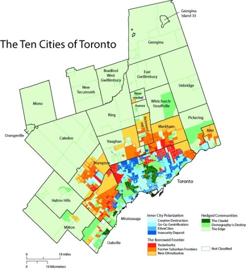
This map of the Ten Cities of Toronto uses a multivariate statistical analysis to explore the relationship between dimensions of housing, citizenship, ethnicity, wealth, labour, and domesticity. Using David Hulchanski’s 2007 research on the Three Cities of Toronto (.pdf) as a foundational base, this research expands the analysis both in spatial and methodological terms. To construct this map, 36 variables were sorted into 6 dimensions, defined by background literature. Each of these six dimensions was explored through a principal components analysis, which picked out important latent patterns between associated variables. The data was then sorted into ten clusters, each cluster a unique combination of the 36 variables, representing a distinct “city” of the Toronto Census Metropolitan Area (CMA).
The resulting map allows for a discussion of the Toronto CMA on two different scales. The separation of urban areas into the three sub-regions of “Inner City Polarization” (blue shades), “Hedged Communities (green shades), and “The Borrowed Frontier” (green shades) allows for a simplified large scale analysis of the urban region. Inner City Polarization is characterized by inner city and inner suburban neighbourhoods with high levels of income polarization. Hedged Communities are defined by relatively static, high income households employed in managerial roles and the financial sector. Lastly, the Borrowed Frontier refers to suburban areas with more recent periods of construction. These areas, specifically the city of “The New”, is characterized by many immigrant households paying high percentages of income homeowner costs.
A large amount of diversity exists within these sub-regions as well, as explained by the unique demographic, social, and economic qualities found in each city. The hue of each city refers to its distance from Toronto’s central business district. A closer examination of each of these collections of neighbourhoods raises a challenge to traditional conceptions of Canadian urban form, and reveals an urban region increasingly characterized by spatial polarization.