Next year, the federal government will begin uploading nearly 2,000 user-friendly flood plain maps, updating them with the most recent geospatial data. Eventually, entire communities will find themselves publicly identified as at-risk. What that will do to the value of their homes and their flood insurance premiums (assuming they can even get insurance), is obvious.
If there is any good news here, it is that communities and homeowners can take steps to drastically reduce flood risk. (Ryan Remiorz/Canadian Press)
Drastic market devaluation
"Oh! Oh!," says Prof. Blair Feltmate, delighted to have been asked. "There is going to be a massive devaluation of the housing industry in Canada, guaranteed. A million will turn into $500,000 very rapidly."
Feltmate is head of the Intact Centre on Climate Adaptation at the University of Waterloo, one of those elite, leading-expert Cassandras so many of us just try to ignore.
Now, before the fever swampers start yelling conspiracy, this push to update flood plain maps is not coming from Liberal climate-change evangelists like Catherine McKenna, Trudeau's environment minister. Or David Suzuki. Or the Green Party. It is coming from the insurance industry. Put another way, conservatives: market forces. Feltmate's centre is largely funded by Intact Insurance, one of the industry's biggest players.
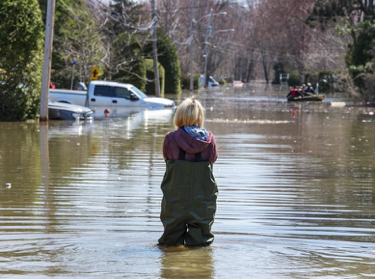
That's hardly surprising; no industry's profits are more immediately threatened by climate change than insurance. Between 1983 and 2008, says Feltmate, annual insurance payouts for catastrophic events in Canada, mostly flooding, averaged between $250 million and $450 million a year. In nine of the 10 years since 2009, the average annual payout has been $1.8 billion. The average payout for a flooded basement is $43,000 and rising.
So the industry wants two things: to push for flood-proofing, and to reassess premiums (or decide where not to insure, period). For that, it needs data. New, updated flood risk maps will give it clear justification to begin dramatically hiking premiums for some homeowners, or refusing them insurance completely. It doesn't take much imagination to guess what will happen when the new maps begin to appear.
"It will put the new areas (newly included in flood plains) into panic mode," says Feltmate.
"There will be big pushback, big alarm. Now your home is stigmatized. A home is worth exactly as much as someone is willing to write a cheque for, and who would write a big cheque for a house suddenly identified as at risk of flooding?
"You will see people begin to default on their mortgages, because they know they owe more on the home than it will ever be worth."
The shorthand term for that in the real estate market is "going underwater." Until now, that term was figurative, not literal.
Furthermore, says Feltmate, the new data will also confirm what experts have known for some time: five per cent of at-risk homes in Canada cannot be saved. Their owners will have to evacuate.