Description
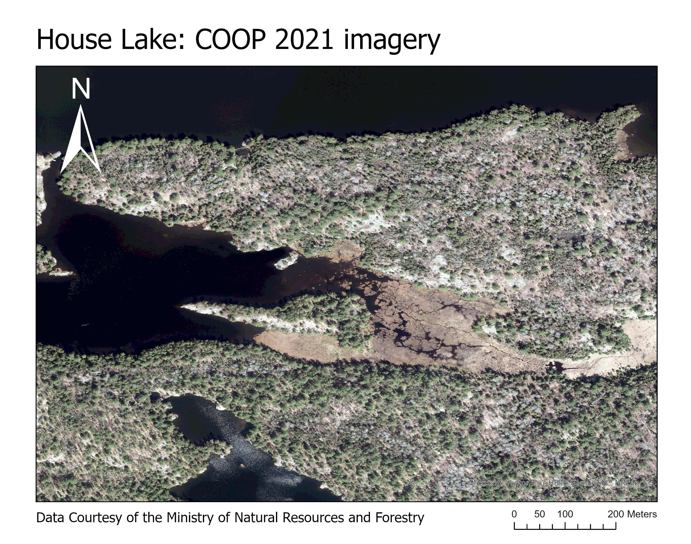
The full-colour digital imagery of Central Ontario was captured from April 2nd to June 1st 2021, encompassing an area of approximately 49,540 square kilometres. The imagery was acquired by the Vexcel UltraCam X and Vexcel UltraCam X Prime digital cameras and was later orthorectified using an elevation dataset generated through image correlation. The orthophotography has a pixel resolution of 20 centimetres and is accurate within 60 centimetres on the ground.
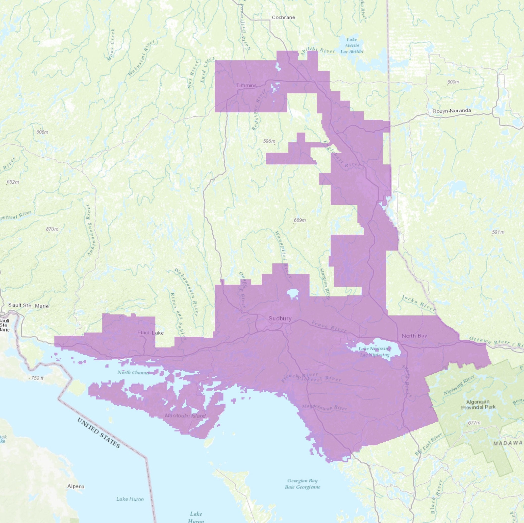
COOP 2021 Coverage
The acquisition area includes the Huron Shores area, East to Sudbury and North Bay, then North to Temiskaming Shores, Kirkland Lake, and Timmins.
CITY OF ELLIOT LAKE
CITY OF GREATER SUDBURY
CITY OF NORTH BAY
CITY OF TEMISKAMING SHORES
CITY OF TIMMINS
MUNICIPALITY OF CALLANDER
MUNICIPALITY OF CALVIN
MUNICIPALITY OF CENTRAL MANITOULIN
MUNICIPALITY OF CHARLTON AND DACK
MUNICIPALITY OF FRENCH RIVER
MUNICIPALITY OF GORDON / BARRIE ISLAND
MUNICIPALITY OF HURON SHORES
MUNICIPALITY OF KILLARNEY
MUNICIPALITY OF MAGNETAWAN
MUNICIPALITY OF MARKSTAY-WARREN
MUNICIPALITY OF MATTAWAN
MUNICIPALITY OF POWASSAN
MUNICIPALITY OF ST.-CHARLES
MUNICIPALITY OF TEMAGAMI
MUNICIPALITY OF WEST NIPISSING
MUNICIPALITY OF WHITESTONE
TOWN OF BLIND RIVER
TOWN OF COBALT
TOWN OF ENGLEHART
TOWN OF ESPANOLA
TOWN OF GORE BAY
TOWN OF IROQUOIS FALLS
TOWN OF KEARNEY
TOWN OF KIRKLAND LAKE
TOWN OF LATCHFORD
TOWN OF MATTAWA
TOWN OF NORTHEASTERN MANITOULIN AND THE ISLANDS
TOWN OF PARRY SOUND
TOWN OF SPANISH
TOWN OF THESSALON
TOWNSHIP OF ARMOUR
TOWNSHIP OF ARMSTRONG
TOWNSHIP OF ASSIGINACK
TOWNSHIP OF BALDWIN
TOWNSHIP OF BILLINGS
TOWNSHIP OF BLACK RIVER-MATHESON
TOWNSHIP OF BONFIELD
TOWNSHIP OF BRETHOUR
TOWNSHIP OF BURPEE AND MILLS
TOWNSHIP OF CARLING
TOWNSHIP OF CASEY
TOWNSHIP OF CHAMBERLAIN
TOWNSHIP OF CHISHOLM
TOWNSHIP OF COLEMAN
TOWNSHIP OF EAST FERRIS
TOWNSHIP OF EVANTUREL
TOWNSHIP OF GAUTHIER
TOWNSHIP OF HARLEY
TOWNSHIP OF HARRIS
TOWNSHIP OF HILLIARD
TOWNSHIP OF HUDSON
TOWNSHIP OF JAMES
TOWNSHIP OF JOLY
TOWNSHIP OF KERNS
TOWNSHIP OF LARDER LAKE
TOWNSHIP OF MACHAR
TOWNSHIP OF MATACHEWAN
TOWNSHIP OF MCDOUGALL
TOWNSHIP OF MCGARRY
TOWNSHIP OF MCKELLAR
TOWNSHIP OF NAIRN AND HYMAN
TOWNSHIP OF NIPISSING
TOWNSHIP OF PAPINEAU-CAMERON
TOWNSHIP OF RYERSON
TOWNSHIP OF SABLES-SPANISH RIVERS
TOWNSHIP OF STRONG
TOWNSHIP OF TEHKUMMAH
TOWNSHIP OF THE ARCHIPELAGO
TOWNSHIP OF THE NORTH SHORE
VILLAGE OF BURK'S FALLS
VILLAGE OF SOUTH RIVER
VILLAGE OF SUNDRIDGE
VILLAGE OF THORNLOE
Spatial reference and data type
These georeferenced images are available in Universal Transverse Mercator (UTM) coordinates; horizontal datum is North American Datum (NAD) 83 CSRS. They are stored as JPG2 image files. The average file size is 23 MB.
Data access
In order to access these data sets, please visit the Geospatial Centre reference desk during reference hours. Library reference staff are available to provide further information about these data sets and to deliver data upon request. Under the terms of the library's license agreement, these data sets are for use by students, faculty, and staff at the University of Waterloo only.
Data manipulation and storage
There are public workstations in the Geospatial Centre that provide access to ArcGIS software programs, program extensions and data manipulation utilities. Patrons may use the Geographic Information System (GIS) and image processing software in the library to view and manipulate the data. Waterloo faculty, students and staff may copy these data for use elsewhere.
Data output
These images may be exported from ArcGIS in a choice of bitmapped formats (also known as raster graphics) including JPG, TIFF, GIF, and BMP or in a choice of vector graphics formats including Adobe Illustrator (AI), Encapsulated Postscript (EPS), and Scalable Vector Graphics (SVG). Yet another option is PDF. The GeoExpress View may also be used to export the image, in whole or in part. The user defines the output resolution.
Use restrictions/licensing/copyright
These data are provided for personal use for academic, research, and/or teaching purposes. A data release agreement must be agreed to before these licensed data can be released. The Ontario Ministry of Natural Resources and Forestry must be acknowledged on any derivative product, whether printed or electronic, including, for example, a printed map, a raster or vector graphic, a web-based application, etc. Patrons are advised to fully respect the provisions of Canada's Copyright Act as well as the terms and conditions imposed by the data provider.
Citation
COOP: Orthophotography 2021 [computer file]. Ontario Ministry of Natural Resources and Forestry (OMNRF), [2021].
Sample view of the data