Data access
Full access to our resources is available to current students, faculty, and staff of the University of Waterloo. To request access, please complete the Ask-Us form indicating the specific layers (shapefiles) you require. Upon completion of the data release agreement form, the dataset will be provided to you via OneDrive.
In-person consultations may also be requested through the Ask-Us form.
Description
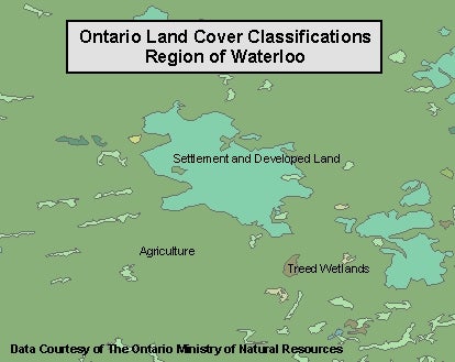
This data resource shows general land cover classification types for the province of Ontario. This information is provided by the Ontario Ministry of Natural Resources (OMNR), and is based on the 1:250,000 National Topographic System (NTS) map sheets, and was made using Landsat TM imagery. The Geospatial Centre has access to data for all of Ontario, comprised of 3 separate land cover databases:
- Far North Land Cover v1.4
- Southern Ontario Land Resource Information System (SOLRIS) v1.2
- the Provincial Land Cover 2000 Edition
The following is a list of the land cover classification types:
- Water
- Marshes
- Open wetlands
- Treed wetlands
- Tundra heath
- Dense deciduous forest
- Early successional forest
- Successional forest
- Sparse forest
- Mine tailings, quarries, bedrock outcrop, mud flats
- Settlement and developed land
- Agriculture
- Unclassified areas (within and outside of province)
Spatial reference and data type
These data sets are available in geographic (lat/long) co-ordinates; horizontal datum is North American Datum (NAD) 83. This data is stored as Esri shapefiles by the Geospatial Centre. Other data formats can be accommodated, as the Geospatial Centre has access to a number of conversion utilities.
Use restrictions/licensing/copyright
This material is provided for academic, research, teaching, and personal use only. A data release agreement must be agreed to before the data is released. The Ontario Ministry of Natural Resources should be acknowledged on any derivative product, such as a map or an image.
Citation
Ontario Land Cover Data [computer file]. Toronto, Ontario: The Ontario Ministry of Natural Resources, [2016].
Sample view of the data