Description
Satellite StreetView is a geospatial product which combines the spatial detail of DigitalGlobe's (now part of Maxar) high-resolution satellite imagery with the content of DMTI Spatial's digital street map. The satellite images are 60 cm resolution, the highest resolution available on the commercial market. The imagery dates from 2002 to present.
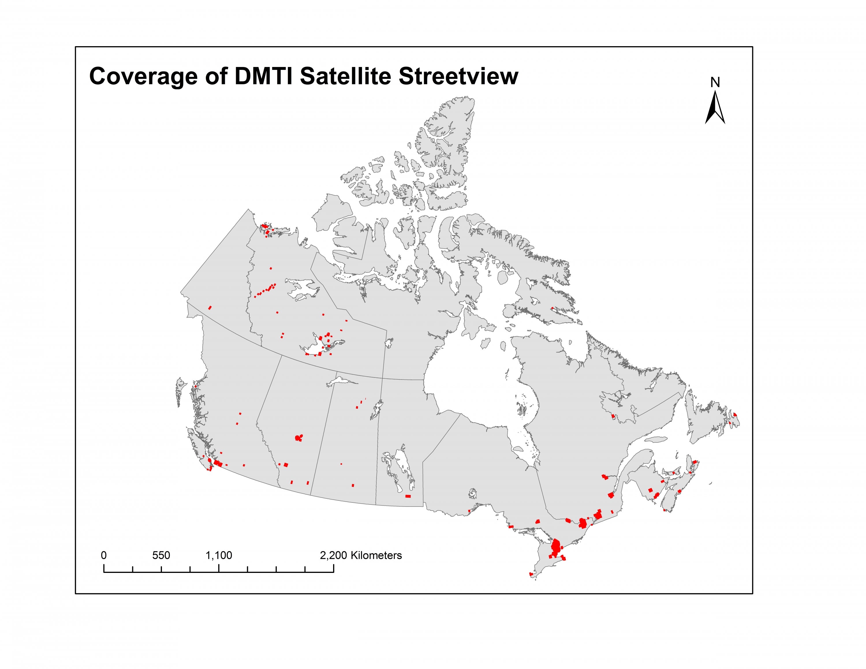
Satellite StreetView is currently available for the following cities:
- Abbotsford, British Columbia (BC) (Sept 2006- July 2007)
- Argentia, New Foundland (NFL) (May 2010)
- BC interior (August 2008)
- Blanchet island mine, Northwest Territories (NWT) (July 2009)
- Bradford, Ontario (ON) (Sept.11, 2012)
- British Columbia interior (BC) (August 2008)
- Brooks (Sept.18, 2011- April 9, 2012)
- Calgary, Alberta (AB) (June - April 2002, November 2011)
- Canol Trail Mile 131 (NWT) (July 2009)
- Canol Trail Mile 152 (NWT) (July 2009)
- Canol Tail Mile 160 (NWT) (August 2009)
- Canol Trail Mile 184 (NWT) (July 2009)
- Canol Trail A1 (NWT) (Oct 2009)
- Canol Trail A2 (NWT) (Sept. 2008)
- Canol Trail A3 (NWT) (Nov. 2008)
- Canol Trail A4 (Sept. 2008)
- Charlottetown, Prince Edward Island (PE) (July 2009)
- Cold Lake (AB) (May 10, 2015)
- Cornwall (ON) (Sept. 2009)
- Creek River (SK) (Sept. 27, 2009)
- Diavik, (NWT) (Aug. 2008))
- Discovery ridge (NWT) ((Mar 2008)
- Dodo canyon (NWT) ((August 2008)
- Edmonton (AB) - (June 2004)(April 2011- May 2011)
- Fort George (May 14, 2015)
- Fort good hope (NWT) (June 2004)
- Fort Resolution (NWT) (Sept.-Aug. 2007)
- Fort Saskatchewan (AB) (April 7, 2010)
- Fort Simpson (NWT) (August 2006 - east) (October 2006 - west)
- Fort Smith (NWT) (July 2006 - 2007)
- Fredericton, New Brunswick (NB) (April - Sept. 2009)
- Greater Toronto Area (ON) - (Sept. - Oct. 2004)
- Guelph east/ west (ON) - (July 2010)
- Halifax, Nova Scotia (NS) - (Oct. - Nov. 2011)
- Halton, Oakville (ON) - (Oct. 2004 - Sept. 2004)
- Hamilton (ON) - (Oct. 2004)
- Hay River - (NWT) - (August 2007)
- Hay River - Dene (NWT) (Sept. 2006)
- High River (AB) - (July 18, 2012)
- Hudsons Hope (BC) - (July 6, 2012 - Sept. 11, 2013)
- Inuvik (NWT) - (June 2005 - August 2007, August 2006, August 2007).
- Iqaluit (Nunavut), (August 2008)
- Jonquiere, Saguenay, Quebec (QC), (July - August 2005)
- Kananaskis (AB) - (Nov 2008)
- Kelowna (BC) - (June 2009)
- Kettle Rapids (MN) - (July 18, 2012)
- Key Lake (SK) - (Sept. 27, 2011)
- Kitchener/ Waterloo/ Cambridge (ON) - (April 2006 - May 2008)
- Labrador city (NFL) - (Sept. 2, 2010)
- Lethbridge (AB) - (March 2004)
- Liten mine (NWT) - (July 2009)
- Medicine Hat (AB) - (May 2004)
- Moncton (NB) - (Jul - Oct. 2010)
- Montebello (QC) - (Nov. 2010)
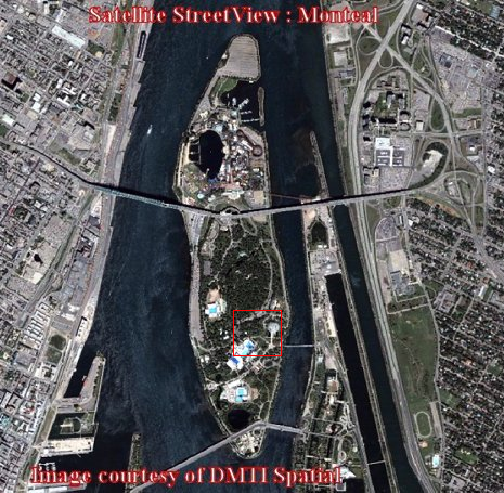
- Montreal (QC) - (April 2002 - August 2005)
- Moose Jaw (SK) - (May 7, 2014)
- Niagara Region (ON) - (Nov. 2002 - June 2003, August - Sept. 2007, April 2010)
- Nanaimo (BC) (Aug 2005)
- North Bay (ON) - (May 6, 2013)
- O'connor lake (NWT) - (July 2009)
- Oshawa (ON) - (May 2011)
- Other (NWT) - (August 2006, June 2006 - May 2008, Oct. 2008)
- Ottawa-Gatineau (ON/QC) - (April 2003 - Oct. 2004, July 2005)
- Parks Lake (SK) - (May 14, 2015)
- Petawawa (ON) - (July 16, 2011)
- Philmore mine, Saskatchewan (SK) - (August 2009)
- Port Alberni (BC) (May 2008) (July 2008)
- Prince George (BC) (Jul 2009, August 26, 2011)
- Port Hawkesbury (NS) - (June 2010)
- Prince Rupert - Port Edward (BC) (May 2009)
- Quebec City (QC) - (June 2003 - August 2004, May 2008, Oct.2011 - Nov.2011)
- Quesnel (BC) - (Aug 2008)
- Radisson (QC) - (June 21, 2013)
- Read Lake (SK) - (Sept. 27, 2011)
- Regina (SK) - (August 2002, Oct. 2011)
- Remediation (NWT) - (May - Sept. 2008, August 2008)
- Sakami (QC) - (June 17, 2009)
- Saguenay (QC) - (July 2005 - Sept.2009, May 15, 2011)
- Saint John (NB) - (Nov 2003 - April 2009)
- Saint John's (NFL) - (Aug 2006 - Sept. 2007)
- Saskatoon (SK) - (June 2004)
- Sault Ste. Marie (ON) - (May 2002 - 2004)
- Sherbrooke (QC) - (April 2006)
- Sidney (BC) - (March 2005)
- Snap lake (NWT) - (August 2006)
- Sooke (BC) - (Sept 2006)
- Sorel (QC) - (July 7, 2012)
- Spider lake (NWT) - (July 2009)
- St. Catharines (ON) - (August 2007)
- Sudbury (ON) - (August 4, 2012)
- Sunset lake mine (NWT) - (July 2008)
- Sydney (North)(NS) - (May 20080 - April 2009)
- Thunder Bay (ON) - (November 2009)
- Toronto, Greater Toronto Area (GTA) (ON) (October 2004 – April 2002, September 11, 2012, March 2007)
- Trois Rivieres (QC) - (March 23, 2012)
- Tuktoyaktuk (NWT) - (July 2007)
- Vancouver (BC) - (August 2010 - September 2011)
- Victoria (BC) - (July 2010)
- Waterbury Lake (SK) - (July 31, 2011)
- Westbay mine (NWT) - (July 2009)
- Whistler (BC) (May 2004)
- Whitehorse, Yukon Territories (YT) - (August 2008)
- Windsor-Detroit, Ontario, Michigan, United States of American (ON-MI USA) - (Feb. 2002 - Oct. 2004, June 2007)
- Winnipeg, Manitoba (MB) (June 2011 – August 2011)
- Wrigley (NWT) - (August 2007)
- Yarmouth (NS) - (August 2010)
- Yellowknife (NWT) - (May 2008)
The Geospatial Centre has access to all of the above imagery however some images have not yet been uploaded to the server. Please contact library reference staff (email) for details.
Spatial reference and data type
These georeferenced images are available in Universal Transverse Mercator (UTM) coordinates; horizontal datum is North American Datum (NAD) 83. They are stored as GeoTIFF image files. The Tiff image tiles range in size from 80MB to over 550MB.
Data access
In order to access these data sets, please visit the Geospatial Centre public services desk during reference hours. Library reference staff are available to provide further information about these data sets and to deliver data upon request. Under the terms of the library's license agreement, these data sets are for use by students, faculty, and staff at the University of Waterloo only.
Data manipulation and storage
There are public workstations in the Geospatial Centre that provide access to ArcGIS software programs, program extensions, and data manipulation utilities. Patrons may use the Geographic Information System (GIS) and image processing software in the library to view and manipulate the data. UWaterloo faculty, students, and staff may copy these data to other media (for example: CD, DVD or Zip disc) for use elsewhere.
Data output
These images may be exported from ArcGIS in a choice of bitmapped formats (also known as raster graphics) including JPG, TIFF, GIF, and BMP or in a choice of vector graphics formats including Adobe Illustrator (AI), Encapsulated Postscript (EPS), and Scalable Vector Graphics (SVG). Yet another option is PDF. The user defines the output resolution.
Use restrictions/licensing/copyright
These data are provided for personal use for academic, research, and/or teaching purposes. Library staff will ask patrons to read and sign a data release agreement before these licensed data can be released. The Ministry of Natural Resources must be acknowledged on any derivative product, whether printed or electronic, including for example, a printed map, a raster or vector graphic, a web-based application, etc. Patrons are advised to fully respect the provisions of Canada's Copyright Act as well as terms and conditions imposed by the data provider.
Citation
Satellite StreetView [computer file]. Markham, Ontario: DMTI Spatial Inc., 2002-present.
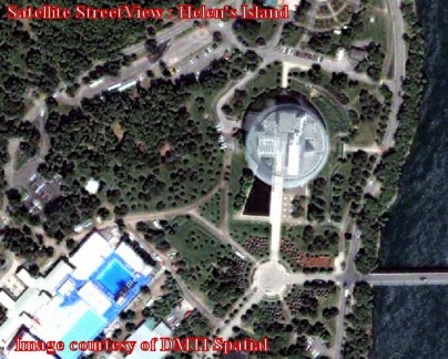
Sample view of the data