Data access
Full access to our resources is available to current students, faculty, and staff of the University of Waterloo. To request access, please complete the Ask-Us form indicating the specific layers (shapefiles) you require. Upon completion of the data release agreement form, the dataset will be provided to you via OneDrive.
In-person consultations may also be requested through the Ask-Us form.
Description
Since its formation in 1957, the Toronto and Region Conservation Authority (TRCA) has been delivering programs for the management and protection of the watersheds within its jurisdiction.
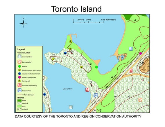
In April 2008 and March 2014, the Geospatial Centre received vector datasets from the TRCA which cover the municipalities of Toronto, Vaughan, Richmond Hill, Markham, Pickering, Ajax and parts of Uxbridge, Whitchurch-Stouffville, Aurora, King, Caledon, Brampton and Mississauga. The fauna and flora layers are very rich in detail. Current data is available from the TRCA Open Data site.
The datasets provided to the Geospatial Centre include:
- Contours (1 metre)
- Ecological land classification (distribution and groupings of plant species)
- Fauna (significant species: birds, squirrels, frogs: alder flycatcher, bobolink, etc.)
- Flora (significant species: wood fern, shagbark hickory, wild ginger, black ash, star-fire, etc.)
- Municipality boundaries
- Natural cover (forest, meadow, beach bluff, ecological succession, wetland)
- TRCA properties
- Vegetation community types (sumac cultural, thicket, willow shrub beach, dry-fresh oak-hardwood deciduous forest)
- Water courses
- Waterbodies
- Watershed boundary
Spatial reference and data type
These data sets are available in Universal Transverse Mercator (UTM). zone 17 co-ordinates; horizontal datum is North American Datum (NAD) 83. These data are stored as Esri shapefiles. Other data formats can be accommodated, as the Geospatial Centre has access to a number of conversion utilities.
Use restrictions/licensing/copyright
These data are provided for personal use for academic, research, and/or teaching purposes. A data release agreement must be agreed to before these licensed data can be released. Toronto and Region Conservation Authority must be acknowledged on any derivative product, whether printed or electronic, including for example, a printed map, a raster or vector graphic, a web-based application, etc. Patrons are advised to fully respect the provisions of Canada's Copyright Act as well as terms and conditions imposed by the data provider.
Citation
Toronto and Region Conservation Authority Environmental Data [2021 computer file], Toronto and Region Conservation Authority.
Sample view of the data