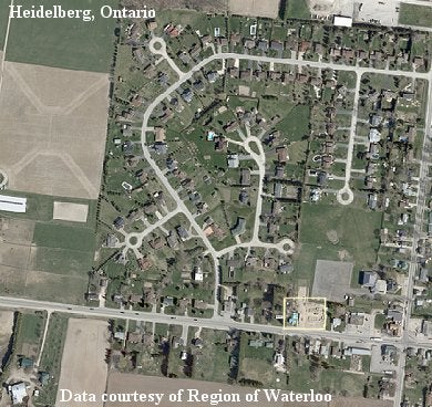
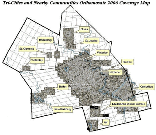
Description
This data resource consists of thirteen full-colour digital orthomosaics, collectively covering the tri-cities and ten nearby communities within the Region of Waterloo. Coverage includes: Kitchener, Waterloo, Cambridge, New Hamburg, Baden, Wellesley, St. Clements, Heidelberg, Elmira, St. Jacobs, Breslau, Ayr and the industrial area north of Ayr, in North Dumfries. This photography was taken in April 2006, by Northway under contract for the Regional Municipality of Waterloo. These images have a 12 cm resolution.
Spatial reference and data type
These mosaics are available in Universal Transverse Mercator (UTM) co-ordinates and are stored in MrSID image format. Horizontal datum is North American Datum (NAD) 83. Other data formats can be accommodated, as the Geospatial Centre has access to a number of conversion utilities.
Data access
To request this data, please fill out the Ask-Us form and include which layers (shapefiles) you are interested in obtaining. The dataset will be shared with you via OneDrive upon completion of the data release agreement form. You may also make an in-person appointment using the same form.
Use restrictions/licensing/copyright
These data are provided for personal use for academic, research, and/or teaching purposes. A data release agreement must be agreed to before these licensed data can be released. The Region of Waterloo must be acknowledged on any derivative product, whether printed or electronic, including for example, a printed map, a raster or vector graphic, a web-based application, etc. Patrons are advised to fully respect the provisions of Canada's Copyright Act as well as terms and conditions imposed by the data provider.
Citation
Tri-Cities and Surrounding Communities Orthomosaics 2006 [computer file]. Waterloo, Ontario: The Regional Municipality of Waterloo 2006.
Sample view of the data