
As Canada’s coasts face a changing climate, coastal communities are tasked with dealing with the unique challenges of storm surges, erosion, and the ensuing floods. Flooding in these regions affects coastal resources that are used by communities and support local economies. As sea levels rise and severe storms occur more frequently, they create a snowball effect as water advances up the shore and storm surges reach further inland causing large-scale floods.
Unique to coastal areas and even large lakes, storm surges are the result of powerful onshore winds and low atmospheric pressure that create waves and force the water towards the shore. These storm surges typically accompany storm systems. The Government of Canada provides an online storm surge hazard map, which allows coastal residents to see if their region experiences a low, medium, or high frequency of storm surges. Storm surge insurance was made available to residents in Atlantic Canada this past summer.
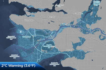
Coastal flood projections assist in visualizing the possible levels of risk. As seen in these projection image, Richmond, British Columbia would be heavily impacted with a 2°C increase in temperature. Even properties neighbouring the Fraser River further inland may be affected. However, these projections do not consider mitigation measures that municipalities are planning to install. Coastal flooding can also affect transit ways, such as the Trans-Canada Highway, an important trade route through the Tantramar Marsh in New Brunswick. Possible solutions include rerouting the highway and raising dikes to allow for routine transportation. These are just two examples of how coastal areas will experience change and how they can develop suitable solutions to counter the impacts.
As appealing destinations to visit and reside in, Canada’s coasts continue to be in high demand. Going forward, coastal cities and communities are tasked with considering these flood risks and adjusting their future development plans. Online sources such as open data or flood projections can greatly assist in the planning process. Whether it’s installing new flood defences or moving communities further inland, tackling the issue of increased coastal flooding is pertinent to the future success of Canadian coastal populations.
View the open storm surge data.
Works cited:
Brash, C. (2016, February 02). Coves, cliffs and lighthouses of Canada's epic east coast. Retrieved November 9, 2018, from https://www.lonelyplanet.com/canada/travel-tips-and-articles/coves-cliffs-and-lighthouses-of-canadas-epic-east-coast/40625c8c-8a11-5710-a052-1479d277e2ba
Cain, P. (2017, November 27). Two Canadian places that could be under water in 100 years - or sooner. Retrieved November 8, 2018, from https://globalnews.ca/news/3845545/how-climate-change-affects-canada/