John's exciting research projects are shown below.
Most projects are related to two main research areas:
- Geoscience Education and
- Coastal Geoscience.
---------------------------------------------
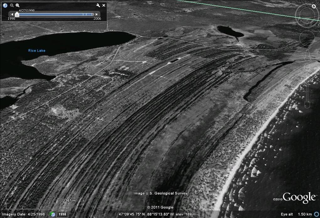
Paleohydrographic Reconstructions in the Upper Laurentian Great Lakes
John is currently a leader in the large and long-standing, multidisciplinary, Laurentian Great Lakes research team (member since 1998) focused on interpreting modern and ancient coastal sediment and sequences to unravel natural drivers of water level change (climate, sediment, outlet, glacial isostatic adjustment) during paleohydrographic reconstruction.
- Summary of research (more than two decades) in Johnston et al. (2014) Paleohydrographic reconstructions from strandplains of beach ridges in the Laurentian Great Lakes. The most-detailed paleohydrographs (individual site and basinwide or outlet) ever reconstructed for the late Holocene (5,000 to present) in the upper Great Lakes (Superior, Michigan and Huron) with a decadal resolution. We were honoured to be included in such an outstanding special publication with such a prestigious organization recognizing one of geology’s founding fathers, Sir Charles Lyell in the Lyell Collection--dating back to the early 1800's, including Lyell's influential book, Principles of Geology.
For basinwide compilations where Outlet Paleohydrographs were reconstructed see the next items below.
- Lake Michigan - Original in Baedke and Thompson (2000) A 4,700-Year Record of Lake Level and Isostasy for Lake Michigan. Updated in Argyilan at al. (2018) Lake-level, shoreline, and dune behavior along the Indiana Southern Shore of Lake Michigan.
- Lake Superior - Johnston et al. (2012) A sault-outlet-referenced mid- to late-Holocene paleohydrograph for Lake Superior constructed from strandplains of beach ridges.
- Lake Huron - in progress.
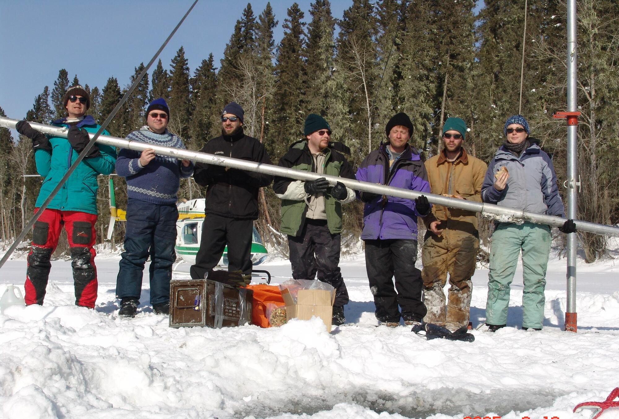
Paleolimnological Reconstructions in the Mackenzie River Watershed
John is currently a leader in the large and long-standing, multidisciplinary, Mackenzie River Watershed research team (member since 2004) focused on unraveling natural (i.e. climate and geomorphic) and anthropogenic (i.e. water extraction or impoundment) drivers of change in this complex and dynamic system in the Peace–Athabasca-Slave River Delta Corridor, an internationally-recognized water-rich floodplain landscape.
- Summary of research (more than a decade) in Wolfe et al. (2012) Developing temporal hydroecological perspectives to inform stewardship of a northern floodplain landscape subject to multiple stressors: paleolimnological investigations of the Peace-Athabasca Delta In this manuscript we synthesize evidence from paleolimnological records that have fostered an unparalleled window into the natural history of this landscape. This is informing effective ongoing stewardship of the world’s largest boreal delta during challenges associated with changes in climate and upstream industrial and agricultural activities.
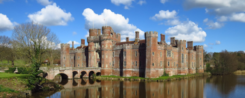
Reconstructing the Medieval environment near the Herstmonceux Castle in Sussex, U.K.
To investigate the complex relationship between climate and culture, we (Geoscientists) are reconstructing the ancient environments to delineate natural variability and establish the temporal (years to several millennia) and spatial (sediment to sedimentary system) context. Reconstructions involve investigating the Pevensey embayment, barrier and lagoon that formed during the late Holocene and was influenced by variations in climate, river flooding, tides and sea level. This is with the Environments of Change research team, studying c. 1000 to 1550 (which coincides with the gradual end of the Medieval
Climate Optimum and the onset of the Little Ice Age), Social Sciences and Humanities Research Council (SSHRC) Partnership Grant (2019-2026) “Environments of Change: Digitizing Nature, History, and Human Experience in Late Medieval Sussex”. Dr. Steven Bednarski (P.I.) of the UW DRAGEN Lab and many collaborators. See the UW Daily Bulletin article.
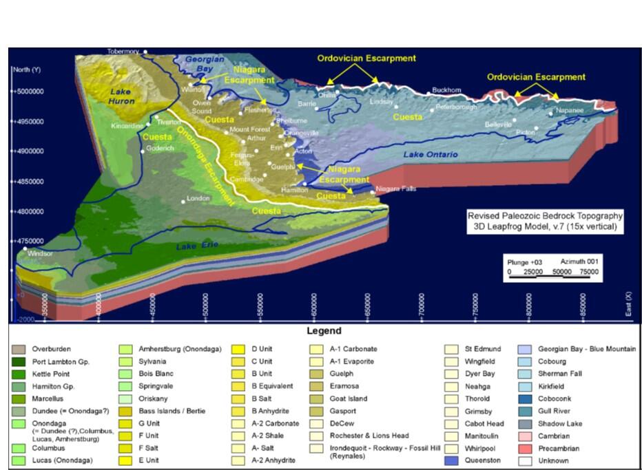
Use of 3D Digital Models in Geoscience Education
We created the first learning framework that unites students with the newly published 3D geological model of Ontario’s Paleozoic geology. This new learning framework was developed in two undergraduate theses (Quinn Worthington 2019 and Jeremy Kamutzki 2020) with students in Earth 235 - Stratigraphic approaches to understanding Earth’s history at the University of Waterloo. This new education framework helps bridge the dimensional and interactive gaps that exist in traditional education integrating together the new 3D geological model (Carter et al. 2019) with the Paleozoic lithostratigraphic chart for southern Ontario (Brunton et al. 2017) and a list of the ‘Top 10 Important Aspects of Ontario’s Paleozoic Geology’ created from input from students and professionals. A summary of the initial, undergraduate theses research was presented at the 2020 Geological Society of America conference, Johnston et al. (2020).
Efforts are continuously underway to improve this learning framework to further improve undergraduate education of future geoscientists and engineers. Educational materials (i.e. 3D print models and XR) are also being created and also tested with people visiting the UWaterloo Earth Science Museum. Some of this research is with the Geological Survey of Canada, Natural Resources Canada (Hazen Russell) and collaborative efforts with Frank Brunton (Ontario Geological Survey), Terry Carter (Carter Geologic) and Jordan Clark (Oil, Gas, Salt, Resource Library).
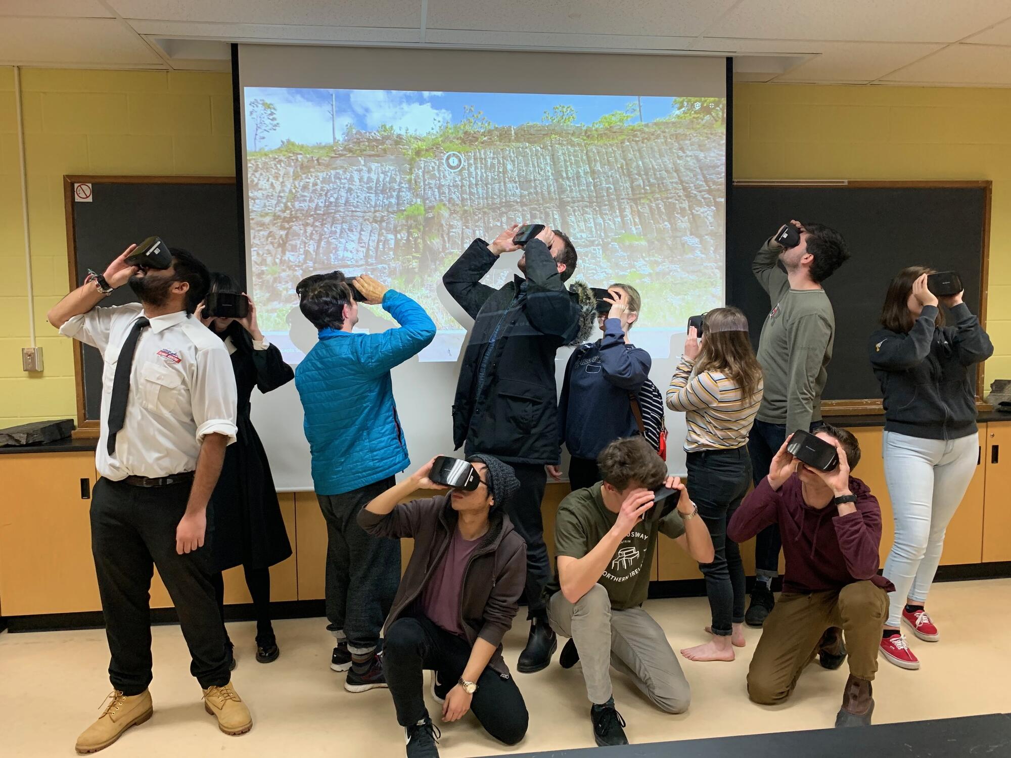
Extended Reality in the Geosciences
Virtual Geoscience tours have been created for (i) Earth 121 - Introductory Earth Sciences for students to immerse themselves in student-guided experiences (i.e. Salt and Amazing Places around the World) and (ii) Earth 235 - Stratigraphic approaches to learning Earth history for students to create their own unique immersive tour, improved through a peer review process. Immersive experiences were initiated through the UWaterloo Dean of Science Undergraduate Teaching Innovation Fund “Using Emerging Technologies to enhance field, experiential and active based learning in Earth and Environmental Sciences” (John Johnston and Jen Parks (P.I.’s) and Keith Delaney, Shaun Frape, Corina McDonald, David Rudolph, Christina Smeaton, and Barry Warner (Collaborators). Research by Henry Visneskie, UWaterloo co-op student over two semesters brought Earth and Environmental Sciences to the forefront (Groundwater Geoscience Open House - Visneskie 2020 and GeoConvention - Visneskie 2020). Invited presentations include Johnston et al. (2019) at the Digital Pedagogy Institute Conference and demonstrations with the Google Expedition Kit at the UWaterloo Dragen Lab and UWaterloo XR CoP or extended reality community of practice. Related research is also UWaterloo undergraduate thesis Henry Visneskie (2021), evaluating virtual field experiences in three classes, meant to improve student learning.
Geoscience knowledge helping manage Natural Park Systems
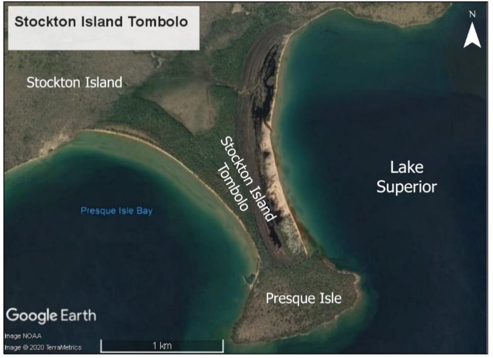
The shoreline is eroding rapidly during relatively high, Lake Superior water levels and potentially threatening inland areas with endangered species. Staff at the Apostle Islands National Lakeshore in Wisconsin approached the Great Lakes Paleohydrographic research team to gain insight. The Stockton Island tombolo (or set of several ancient shorelines) connecting two islands together in Lake Superior are being interpreted to explain the context for recent erosion and future potential scenarios. This is part of a National Park Services, U.S.A. grant. “Optical Dating of the Stockton Tombolo, (Kenneth Lepper (P.I.), Department of Geosciences, North Dakota State University and Erin Argyilan of the Department of Geosciences, Indiana University Northwest, Todd Thompson of the Indiana Geological and Water Survey and John Johnston (Collaborators). Related research is UWaterloo undergraduate thesis Dayna Opersko (2021) attempting to create an accurate paleohydrograph from LIDAR data.
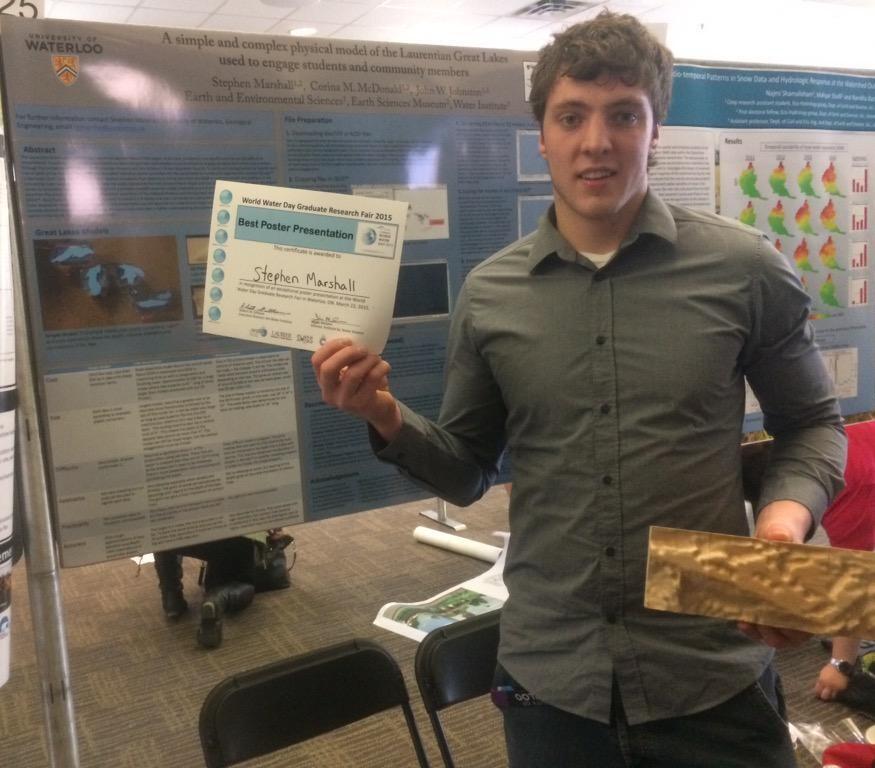
First 3D Model Print of Great Lakes Bathymetry
To help the public appreciate the real complexities in shape and size of the Laurentian Great Lakes, a complex multidimensional model produced on a 3-D printer was innovatively completed by Stephen Marshall (2015) during his first UWaterloo co-op work term supervised by John Johnston and Corina McDonald (UW Earth Science Museum curator). Great Lakes bathymetric data from the Great Lakes Environmental Research Laboratory of the National Oceanic and Atmospheric Administration were manipulated in QGIS™, 3DEM™, AccuTrans 3D™, and Blender™ programs to create a 3-D Model and then converted to a stereolithography file format to be printed on a fused deposition modeling (FDM) machine. This complex physical model is being used to engage students and community members in better understanding and appreciating the largest fresh surface-water system in the world, the Laurentian Great Lakes.
Research page still in progress...