Peatlands are globally significant carbon stores, yet vegetation phenology at fine spatial scales remains an understudied component of peatland functioning. This limits our understanding of how these ecosystems operate and respond to environmental change. The PeatPic Project is an international effort designed to address this gap by collecting and analysing plot-scale digital photographs from peatlands across multiple climate zones. Its objective is to quantify vegetation phenology, particularly green leaf development and senescence using a novel, community science (also known as ‘distributed data’ collection) method.
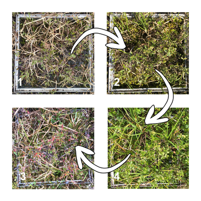
Example of how plot-level peatland vegetation communities can change colour of the growing season. Photo credit: Scott J. Davidson
While satellite remote sensing can provide valuable large-scale data, they are often unable to capture the high spatial heterogeneity within peatland plant communities. The PeatPic Project employs repeated RGB imagery at ≤1 m² resolution to deliver standardised, high-frequency measurements of vegetation greenness. These datasets support cross-site comparisons and could help to link vegetation dynamics with carbon uptake and emission patterns.
Results indicate substantial variability in phenological timing between peatland types and climate regions. Earlier leaf-out, prolonged growing seasons, and differences between moss- to shrub-dominated communities can alter rates of photosynthesis and respiration, particularly under warming and drying trends. One of our goals with this project was to produce plot-scale datasets that can improve parameterisation of carbon and Earth system models by providing empirical observations of vegetation change and its effects on peatland function.
Although The PeatPic Project is global in scope, it has particular relevance to Canada, where peatlands cover approximately 12 per cent of the land area and store a significant proportion of national terrestrial carbon. Canadian research teams contributed photographs from sites within boreal and temperate regions, and data could be included in future national modelling frameworks such as the Canadian Model for Peatlands (CaMP). Observations of vegetation phenology are especially relevant for assessing how environmental changes such as water-table fluctuations, permafrost thaw or land-use change influence ecosystem functioning across a variety of peatlands.
The project’s approach could also support evaluation of restoration and management strategies. In disturbed or previously drained peatlands, monitoring phenological recovery can highlight impacts to vegetation communities, and alongside other measurements, understand future carbon dynamics. This aligns with current efforts in Canada and elsewhere to report greenhouse gas balances from peatlands and to monitor progress toward climate targets.
An important feature of the PeatPic Project is its commitment to open science. The project’s methodology including image acquisition, data processing and quality control procedures, is openly accessible. The published protocol enables researchers, land managers and community-based monitoring groups to adopt the same approach with minimal cost and technical requirements. By standardising plot-scale photographic sampling across sites and regions, the project facilitates methodological consistency, which is essential for generating comparable datasets and advancing synthesis across networks.
All core datasets, including processed greenness indices and site information are now openly available. This allows other researchers to reuse the data for phenological analysis, model calibration or integration with carbon flux, hydrological or biodiversity datasets. The published paper provides full methodological detail and links to data archives, supporting reproducibility and enabling further development of the approach.
The decision to make protocols and data freely available is intended to reduce barriers to participation. Researchers working in underrepresented regions, including northern peatlands, tropical peat swamps and restored sites, can contribute to and benefit from the network without reliance on specialised equipment. This collaborative structure promotes wider adoption of the method and supports global-scale assessment of peatland vegetation dynamics and carbon function.
For Canada and other peatland-rich countries, this open-access framework aligns with national monitoring and reporting needs. The integration of publicly available phenological data with existing infrastructure, such as flux towers and national carbon models, increases transparency and improves confidence in carbon accounting. Open-access datasets also support training, student research and community science initiatives in remote or Indigenous-led monitoring programmes.
By combining standardised low-cost methods with open data and protocol sharing, The PeatPic Project demonstrates a scalable model for ecosystem monitoring. Its approach is designed not only to generate new scientific knowledge, but also to encourage broad participation in documenting how peatlands respond to environmental change.
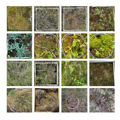
Example of the types of plots used within The PeatPic Project. Photo credit: Scott J. Davidson
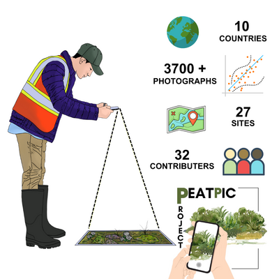
Summary of the results of The PeatPic Project. Photo credit Scott J. Davidson