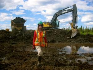
 In the oil sands development areas near Fort McMurray, where peatlands comprise up to 65% of the landscape, most of which being fens, active mining occurs on over 250 km2and is expected to cover approximately 1400 km2by 2023 (Alberta Environment, 1999). Large tracts of undisturbed peatland are being removed in the process. This research will evaluate the reclamation of mined landscape to a fen and its watershed. Based on a conceptual design presented by Price et al. (2010) and a revegetation strategy guided by Rochefort et al. (2003), a construction plan has been created (Daly, 2009), commencing August 2010. However, fen creation is a new concept, and designing a fen and its watershed is an untested concept.
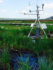
Fen peatlands rely on ground- or surface water inflows to sustain the water balance and modify the water quality. The key to explaining the success of plant establishment and carbon exchanges within the system lies in understanding the hydrology and the associated transport of Na and NAs within and between constructed/natural upland areas and the constructed fen. The adequacy of recharged water for the fen is ultimately decided by its ability to sustain conditions wet enough to support fen-vegetation and suppress carbon loss. However, in the Western Boreal Plain annual water deficits exist most years, with wet years occurring on a 10 – 15 year cycle. Thus, the water budgets of wetlands here are dominated by vertical fluxes. The presence of persistent seasonal frost in these wetlands causes a perching of the water table that may be essential for sustaining an adequate level of wetness (Petrone et al., 2008). The role of this mechanism in fens is untested, and the ability of our reconstructed, revegetated fen to mimic natural systems is uncertain. We will document the process and if important, endeavour to promote it. Furthermore, the constructed landscapes will have differences in hydrology that will influence biogeochemical cycling and carbon dynamics, and therefore trace gas exchange.
GRADUATE STUDENT POSITIONS
The following graduate student positions are available.
PhD
 This position will begin in 2020 and examine the implications of design choices and strategies adopted to optimize fen reclamation in the future. Particular emphasis will be placed on the ecohydrological control on evapotranspiration and the role of persistent seasonal ice on lateral and vertical water fluxes from the constructed fen. This position will require field measurement and modelling, and will be best suited for a student with a strong foundation in hydrology or climatology.
PhD & MSc

Water fluxes and system evolution of mine pit lakes: Fully funded MSc and PhD students are being sought to work on research on End-Pit Lakes in the Athabasca Oil Sands Region. All oil sands mine closure landscapes are designed to include pit lakes. Thus, designing and constructing self-sustaining pit lake ecosystems in an accelerated timeframe at the commercial scale is a critical component of oil sands mine reclamation and closure landscape designs. Coal and metal mines have historically reclaimed mine pits into functioning lake ecosystems, although with varying success. However, there is much less information regarding pit lake functioning in an oil sands setting, and more research is needed to evaluate system design features and performance. This information will inform future design optimizations and identify the critical issues and considerations for designing and constructing pit lakes at the commercial scale. Specific projects include: 1) Identify the dominant components of the water budgetof the Upland Watershed and the DPL (individually and collectively) now, and evaluate how will this change in the next 5, 10, 20 and 50 years to help determine if the DPL is self- sustainable; 2) Determine the significant upland features that ensure adequate flow to the lake, and assess how these features and processes will evolve as vegetation develops and influences soil moisture dynamics; and 3) Establish the residence time of the pit lake, and how will this change when scaling up to commercial-scale, and what the implications will be for water quality.
PhD
 This position will begin in 2020 and evaluate how fluxes of water and carbon dioxide from ecosystems can be used to establish equivalent capability in an oil sands reclamation framework. This will use state-of-the-art measurements of ecosystem-scale fluxes of water, energy and carbon from a range of reclaimed, natural and disturbed sites. This will lead to an understanding of the timing, rate and quantity of water balance components, the interactions with nutrient availability, and how these are sensitive to ecosystem change (primary and secondary succession) and climate variability. Such information will help establish the key performance indicators of ecosystem success making site assessment more efficient and scientifically sound. This student will also strive to provide a mechanistic understanding of how ecosystem site and age affect water, energy and carbon fluxes by examining the sensitivity of evapotranspiration, net ecosystem exchange of CO2 and water use efficiency to soil water limitations, soil nutrient status, climate and ecosystem age and placement strategy. This will help standardize productivity metrics to assess/predict the trajectory of reclaimed systems.
MSc & PhD

Peatland Reclamation:
Fully funded MSc and PhD positions are available in peatland reclamation work in the Athabasca Oil Sands Region. In Northern Alberta, where oil sands are extracted, open pit mining covers an area of ~895 km2, and peat dominated wetlands fed by groundwater, mostly fens, cover about half of this area. Industry is required to return the landscape to equivalent functionality. This means that functioning wetlands must be returned to the landscape as part of their landscape reclamation effort. An experimental fen system was constructed, along with the entire watershed that is required to generate groundwater flows that sustain an appropriate level wetness in the fen peatland. Specific projects include:
1) Examine soils and vegetation treatments on previously reclaimed sites to quantify partitioning of vertical fluxes of energy and water. This project will use a range in LFH and vegetation treatments on previously reclaimed sites to quantify the partitioning of the vertical fluxes of energy and water, and model (Gash-modified, CRHM) the relative importance of interception losses to the overall moisture regime of these systems. This work may further examine vascular vegetation plots (differing communities, densities and structure) to understand how the ratio of transpiration:evaporation varies as a function of canopy and soil development.Development of conceptual and empirical models of vegetation community composition and function under a broad range of hydrological and geochemical conditions and nutrient availability will allow prediction of plant community composition and production, and their functioning under potential reclamation scenarios. The results will help inform industry how design decisions will impact reclamation outcomes from a vegetation composition and structure as well as biogeochemical function perspective.
2) Incorporate spatial and temporal patterns and rates of water, nutrients and carbon stores and fluxes to, from, and within natural reference fens into a modelling framework to examine the trajectory of reclaimed systems under varying climatic scenarios. The spatial and temporal patterns of fundamental ecosystem processes will be added to our database, which will be used to evaluate the performance of the system in the first 10 years and used to refine and calibrate our models. The data will show us if the hydrological function of the system can ensure sufficiently wet conditions in the fen, even through drier periods of the regional climate cycle, and if these conditions will be sufficient for net carbon sequestration in most years.
3) Use a combination of modelling approaches (i.e. CRHM, GSFLOW-PRMS, HYDRUS) to represent feedbacks in scaled-up system; determine optimum wetland:upland area in the reclaimed landscape and evaluate the resilience of natural systems in the Boreal Plains landscape. With explicit consideration to the anticipated types and relative quantities of reclamation materials available in the closure landscape, determine optimal ratios and spatial configuration of constructed uplands, focused recharge features and wetland/peatland ecosystems that create sustainable systems and maximize the relative area of wetland/peatland features, while maintaining efficient water use at the landscape scale. These models will be used to analyze the feedback between different landforms at a wide range of scales, and conceptually track their development through time (e.g., from initial conditions to many decades post-construction) as mediated by variable precipitation, evapotranspiration, runoff and evolving material properties. Combined with sensitivity analyses these model results will offer the capability to evaluate scenarios with the many demands and constraints of materials available for landform reconstruction and landscape reclamation. Furthermore, these models will illustrate the tolerance of these systems to unintentional variance from design due to the practical difficulties of constructing systems at the landscape-scale.
MSc
 Ecohydrological Evolution of a Constructed Fen in the Athabasca Oil Sands Region. These fully funded MSc positions will begin in 2019 and will: quantify the hydrological/microclimatic effects of the developing vegetation layer in a constructed fen, its surrounding upland and reclaimed slopes on the trajectory of ecohydrological conditions in the constructed peatland; examine the constructed fen response to water stresses associated with greater weather variability; and, determine the relative importance of internal water conservation mechanisms versus external water sources for the long-term feasibility/maintenance of the constructed fen. As well as work on the constructed watershed, these projects will also analogues from a range in natural fens in the oilsands development region. This will assess the required hydrological conditions to produce the ecological functioning necessary to produce a sustainable wetland system within the subhumid climate of the Western Boreal Plain. This position will involve field measurements and be best suited for a student with a strong background in hydrology or climatology, and some experience in ecology.
PhD
Boreal Plains Ecohydrology: A fully funded PhD position is being recruited to examine the long-term success of ecosystems along an environmental gradient, which requires an understanding of the landscape-scale water balance and the respective hydrologic roles of these ecosystems. While there is considerable knowledge of natural analogue systems in the literature and from other programs, the vertical versus lateral partitioning of water in the sub-humid Boreal Plains requires careful consideration of all hydrological fluxes combined with a knowledge as to how these fluxes will change with ecosystem development and a variable climate. Considering that the greatest variability in water balance is precipitation (as both rain and snow) and evapotranspiration (based on age of the landscape, species type, stage of growth and moisture stress). This work will make use of an unprecedented network of 13 flux sites spanning peatlands and forests in the Boreal Plains to provide water balance information (P-E envelopes) for all representative landscape units in the region. Flux measurements of a range in site and climatic conditions will provide time-varying envelopes, which will allow an empirically-driven estimate of water available for recharge/runoff across the landscape.
 This post-doctoral fellow, available immediately, will develop future climate change and extreme weather scenarios for the Boreal Observatory Network (Global Water Futures) and link to future fire regimes and boreal ecohydrology vulnerability research, oil sands mine water management and water futures risk assessment framework. This work will be a component of the Global Water Futures program, Boreal Water Futures component to develop improved pan-boreal future climate change, extreme weather, and fire regimes predictions through the collaboration with the core GWF future climate outputs and with a key stakeholder and user – the Canadian Forest Service, leveraging existing infrastructure and partner in-kind support to establish an evidence-based pan-Canadian Boreal Observation Network of boreal forests and wetlands to assess boreal water services vulnerability, and collaborate with NGO and industry users to integrate hydrological modelling approach to assess water futures risk at the wildland-society interface (mine management and communities).