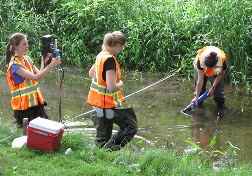
Monitoring the watershed in real-time
Online resource provides detailed data on water quality and hydrologic conditions

Online resource provides detailed data on water quality and hydrologic conditions
By Victoria Van Cappellen Faculty of ScienceEarth and Environmental Sciences Professor Dave Rudolph and his group within the Southern Ontario Water Consortium (SOWC) have successfully launched their smart watershed data integration platform to monitor the hydrologic conditions and water quality within a region of Ontario’s Grand River watershed and to facilitate new innovations in watershed management.
The project, in collaboration with IBM Canada, is currently streaming real-time data online from a distributed network of weather stations and surface and subsurface hydrologic sensor arrays, which collect and transmit data through wireless telemetry to a central recording location. Additional sensors will be added to the website in the coming months.
The network not only records data, but uses information from the sensors to provide automatic alerts whenever sampling frequency needs to increase during intense, short-lived environmental events like storms.
The pilot project has been installed across an 80-square-kilometre subcatchment of the Grand River watershed, the largest inland river system in southern Ontario. The Grand River watershed covers 25 per cent of the Canadian land area draining into Lake Erie. The diverse land uses within the watershed — urban, agricultural, and forested — make it an ideal testing ground for a variety of stakeholders.
Water scientists are realizing that groundwater and surface water are integrated, finite resources where physical and chemical changes in one reservoir may directly lead to changes in the other.
Unfortunately, rivers and lakes in heavily developed areas, like southern Ontario, are challenged to assimilate the cumulative inputs from wastewater treatment plants and watershed runoff.

“We can no longer depend on our water resources to solve our problems for us,” said Rudolph, also a member of the Water Institute. “Our hydrological system has lost the resilience to handle whatever we throw at it.”
Urban planners need better data to safeguard our drinking water supplies and quantify the effects of intense population growth on vital ecosystems.
In addition to monitoring climatic and surface water dynamics, the watershed monitoring infrastructure and data platform also track a wide range of parameters, including soil moisture and surface water temperature along with water quality indicators such as dissolved oxygen, pH nitrate and salinity.
Traditional watershed research has been limited by the amount of data that could be collected and analyzed. Once data from the smart watershed sensors has been transmitted to the central computer, water scientists can manage and merge data sets together and analyze the unprecedented volume of data.
“In most cases, we have the models needed to make water-related predictions, but what we often lack are the data to appropriately inform these models,” said Rudolph.
The ability to connect to the computational power of IBM software is major benefit. And the flexibility to be able to deploy the monitoring infrastructure according to a project need, combined with access to real-time data, opens up unique opportunities for working with academic and private sector partners.
The smart watershed project joins an elite, international group of projects that are revolutionizing how we monitor our water resources in the face of climate change.
The Netherlands’ Digital Delta is another ground-breaking project in collaboration with IBM that uses Big Data to transform flood control and management across the Dutch water system.
The Southern Ontario Water Consortium is a multi-institutional consortium led by University of Waterloo that supports capacity for the development and testing of water innovations. Rudolph leads the SOWC Watershed Node, one of six research or demonstration areas within the SOWC.

Read more
Nanoparticles invented at the University of Waterloo remove pollutants from water when light is shone on them

Hand holding small pieces of cut colourful plastic bottles, which Waterloo researchers are now able to convert into high-value products using sunlight. (RecycleMan/Getty Images)
Read more
Sunlight-powered process converts plastic waste into a valuable chemical without added emissions

Dr. Travis Craddock, professor and Canada Research Chair, says the team's findings change our basic knowledge of biology (University of Waterloo).
Read more
New study reveals quantum-level effects in biology with major implications for treatment of some brain diseases
The University of Waterloo acknowledges that much of our work takes place on the traditional territory of the Neutral, Anishinaabeg, and Haudenosaunee peoples. Our main campus is situated on the Haldimand Tract, the land granted to the Six Nations that includes six miles on each side of the Grand River. Our active work toward reconciliation takes place across our campuses through research, learning, teaching, and community building, and is co-ordinated within the Office of Indigenous Relations.