Contact the Geospatial Centre
Dana Porter Library, Room 328
University of Waterloo Library
Waterloo, Ontario N2L 3G1
Email: librarygeo@uwaterloo.ca
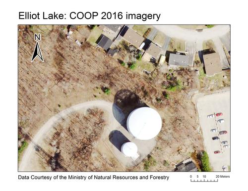
This image data is the result of private and government entities working together under the coordination of the Ontario Ministry of Natural Resources and Forestry (OMNRF). Fugro was contracted by OMNRF to acquire and process the full colour digital imagery which encompassed an area of approximately 53,729 square kilometres; and collected between May 6th and June 10th, 2016 using Leica ADS100 Digital Camera systems. Imagery acquisition was performed at 2,377 meters above mean terrain (AMT) to produce a 20 cm resolution.
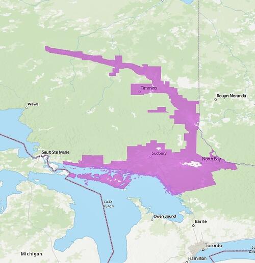
COOP Coverage
The acquisition area includes the Huron Shores area, East to Sudbury and North Bay, then North to Temiskaming Shores, Kirkland Lake, and Timmins. Also included in the capture are Hearst, Kapuskasing, Cochrane, and Manitoulin Island.
These georeferenced images are available in Universal Transverse Mercator (UTM) coordinates; horizontal datum is North American Datum (NAD) 83 CSRS. They are stored as JPG2 image files. Average file size is 23 MB.
In order to access these data sets, please visit the Geospatial Centre reference desk during reference hours. Library reference staff are available to provide further information about these data sets and to deliver data upon request. Under the terms of the library's license agreement, these data sets are for use by students, faculty, and staff at the University of Waterloo only.
There are public workstations in the Geospatial Centre that provide access to ArcGIS software programs, program extensions and data manipulation utilities. Patrons may use the Geographic Information System (GIS) and image processing software in the library to view and manipulate the data. Waterloo faculty, students and staff may copy these data for use elsewhere.
These images may be exported from ArcGIS in a choice of bitmapped formats (also known as raster graphics) including JPG, TIFF, GIF, and BMP or in a choice of vector graphics formats including Adobe Illustrator (AI), Encapsulated Postscript (EPS), and Scalable Vector Graphics (SVG). Yet another option is PDF. The GeoExpressView may also be used to export the image, in whole or in part. The user defines the output resolution.
These data are provided for personal use for academic, research, and/or teaching purposes. A data release agreement must be agreed to before these licensed data can be released. Ontario Ministry of Natural Resources and Forestry must be acknowledged on any derivative product, whether printed or electronic, including for example, a printed map, a raster or vector graphic, a web-based application, etc. Patrons are advised to fully respect the provisions of Canada's Copyright Act as well as terms and conditions imposed by the data provider.
COOP: Orthophotography 2016 [computer file]. Ontario Ministry of Natural Resources and Forestry (OMNRF), [2016].