Contact the Geospatial Centre
Dana Porter Library, Room 328
University of Waterloo Library
Waterloo, Ontario N2L 3G1
Email: librarygeo@uwaterloo.ca
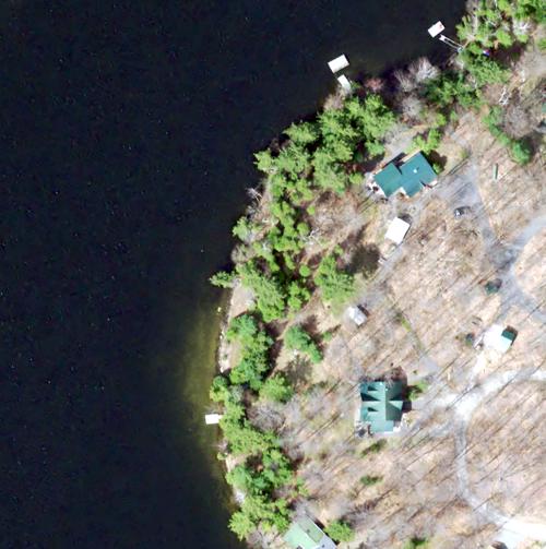
Received from the Ontario Ministry of Natural Resources, the Digital Raster Acquisition Project (DRAPE) imagery was collected during leaf off conditions between April 28th and June 7th, 2014. Fugro acquired the Digital Imagery with sensor Leica geosystems ADS100 Digital Camera systems, including inertial measuring unit (IMU) and dual frequency airborne GPS were used for the digital image acquisition. The true colour data has a resolution of 20 cm and encompasses an area of approximately 37,290 square kilometres.
Drape 2014 coverage
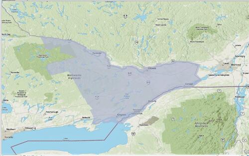
These georeferenced images are available in Universal Transverse Mercator (UTM) coordinates; horizontal datum is North American Datum (NAD). Data are stored as 20 cm true colour 1km x 1km Tiff or jpg2 tiles. Average file size for 1km tiles is 104 mb.
In order to access these data sets, please visit the Geospatial Centre Reference Desk during reference hours. Library reference staff are available to provide further information about these data sets and to deliver data upon request. Under the terms of the Library's license agreement, these data sets are for use by students, faculty, and staff at the University of Waterloo only.
There are public workstations in the Geospatial Centre that provide access to ArcGIS and software programs, program extensions and data manipulation utilities. Patrons may use the Geographic Information System (GIS) and image processing software in the library to view and manipulate the data. UWaterloo faculty, students and staff may copy these data to other media (for example: CD, DVD or Zip disc) for use elsewhere.
These images may be exported from ArcGIS in a choice of bitmapped formats (also known as raster graphics) including JPG, TIFF, GIF, and BMP or in a choice of vector graphics formats including Adobe Illustrator (AI), Encapsulated Postscript (EPS), and Scalable Vector Graphics (SVG). Yet another option is PDF. The user defines the output resolution.
These data are provided for personal use for academic, research, and/or teaching purposes. Library staff will ask patrons to read and sign a data release agreement before these licensed data can be released. Ontario Ministry of Natural Resources must be acknowledged on any derivative product, whether printed or electronic, including for example, a printed map, a raster or vector graphic, a web-based application, etc. Patrons are advised to fully respect the provisions of Canada's Copyright Act as well as terms and conditions imposed by the data provider.
DRAPE : Orthoimagery 2014 [computer file]. Ontario Ministry of Natural Resources.
Data Courtesy of the Ontario Ministry of Natural Resources


