Data access
Full access to our resources is available to current students, faculty, and staff of the University of Waterloo. In order to access this data set, please request an appointment through the Ask-Us form. Geospatial Centre staff are available to provide further information about these data sets and to deliver data upon request.
Under the terms of the library's license agreement, these data sets are for use by students, faculty, and staff at the University of Waterloo only.
Description
This data resource consists of 921 individual tiles that collectively cover the City of Toronto. The data sets were provided to the library by the City of Toronto, Survey and Mapping Services, in April 2005. Acquired as a set of AutoCAD drawings, this is a hybrid product combining elements of topographic and parcel mapping; features include property boundaries, building envelopes, railway lines, major watercourses, and much more. Please see the list below for all available features. Layers shown in bold in the list below are also available as seamless coverages for downtown Toronto. Nominal scale of these features is 1:2,000. Individual tile numbers can be found by using the property data map index (PDF).
Received on May 24, 2011 by secure FTP from the Geospatial Competency Centre, Mapping Services, City of Toronto, an updated set of tiled Toronto Property Data maps (PDMs) with print date of February, 2011. This data set has 921 tiles available in DWG (AutoCAD) format which were converted to shapefile format, then merged to form a seamless feature for the City of Toronto.
Received April, 2019 updated PDMs (print date of July 2018). The 921 tiles are available only in DWG format and have no projection.
Individual tile numbers for all years can be found by using the property data map index (PDF).
Property data types available for the City of Toronto
- bridges
- buildings
- catchment basins
- curbs
- electric poles
- garages
- general poles
- hydrants
- hydrographics
- light standards
- miscellaneous structures
- pathways
- pedestrian street light
- property lines
- railways
- rivers, streams, ponds
- shorelines
- spot heights
- street car tracks
- street lines
- subway tracks
- telephone poles
- traffic lights
- traffic light standards
- walkways
The City provides the following description of this product:
Property Data Maps: elements from parcel mapping, OAR,and TCL 2011 and elements from ESM 2005. There are 921 files for the entire city, set in DWG format. This set of maps is a hybrid product, combining elements of topographic (ESM), parcel mapping, the One Address Repository (OAR), and Toronto Street Centreline (TCL).
Coordinate system: Modified Transverse Mercator, zone 10, North American Datum (NAD) 27. Format is DWG.
2011 Datafiles are stored on NAS in: \toronto\PDM_dwg_Feb2011. Library staff will endeavour to convert the projection and transform the datum to Universal Transverse Mercator (UTM) zone 17, NAD 83 and merge the 921 DWG files into a seamless shapefile for the entire city.
Spatial reference and data type
This data set is available in UTM co-ordinates; horizontal datum is NAD 83. These data are stored as AutoCAD DWG files. Other data formats can be accommodated, as the Geospatial Centre has access to a number of conversion utilities.
Data access
In order to access these data sets, please visit the Geospatial Centre reference desk during reference hours. Library reference staff are available to provide further information about these data sets and to deliver data upon request. Under the terms of the library's license agreement, these data sets are for use by students, faculty, and staff at the University of Waterloo only.
Data manipulation and storage
There are public workstations in the Geospatial Centre that provide access to both ArcGIS and ArcView software programs, program extensions and data manipulation utilities. Patrons may use the Geographic Information System (GIS) and image processing software in the library to view and manipulate the data. UWaterloo faculty, students and staff may copy these data to other media (for example: CD, DVD or Zip disc) for use elsewhere.
Data output
These data may be exported from ArcGIS in a choice of bitmapped formats (also known as raster graphics) including JPG, TIFF, GIF, and BMP or in a choice of vector graphics formats including Adobe Illustrator (AI), Encapsulated Postscript (EPS), and Scalable Vector Graphics (SVG). Yet another option is PDF. Patrons may use the library's colour printers to print map views or tabular views of the data.
Use restrictions/licensing/copyright
These data are provided for personal use for academic, research, and/or teaching purposes. A data release agreement must be agreed to before these licensed data can be released. The City of Toronto, Geospatial Competency Centre must be acknowledged on any derivative product, whether printed or electronic, including for example, a printed map, a raster or vector graphic, a web-based application, etc. Patrons are advised to fully respect the provisions of Canada's Copyright Act as well as terms and conditions imposed by the data provider.
Citation
City of Toronto Data [computer file]. Toronto, Ontario: City of Toronto, Geospatial Competency Centre [2018].
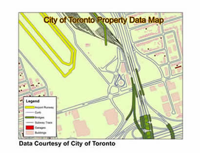
Sample view of the data