Data access
Full access to our resources is available to current students, faculty, and staff of the University of Waterloo. To request access, please complete the Ask-Us form indicating the specific layers (shapefiles) you require. Upon completion of the data release agreement form, the dataset will be provided to you via OneDrive.
In-person consultations may also be requested through the Ask-Us form.
Description
This vector data resource provides municipal planning information for the Region of Waterloo. This data is provided by the Region of Waterloo, and consists of coverages for the period of 2001-2024.
Vector data coverages are listed in the table below.
Municipal planning information for the Region of Waterloo
- Active transportation
- Address points
- Aggregate licenses
- Airfields
- Airport
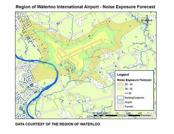
- Airport noise exposure
- Airport zoning regulations
- Ambulance stations
- Buildings (incomplete)
- Building permits
- Cemeteries
- City, town, village boundaries
- Community centres
- Contours
- Creeks
- Cycling facilities
- Digital Elevation Model (DEM)
- Designated areas
- Designated properties
- Downtown boundary
- Early learning child care centres (licensed)
- Enova Hydro Poles
- Environmentally sensitive protected areas
- Fire stations
- Forests
- Forests owned by the Region
- Garbage routes
- Grand River Transit (bus routes and stops)
- Green bin routes
- Ground water recharge
- Ground water (treatment and well system, aquifer type, water depth)
- Heritage built resources
- Heritage resource areas
- Hydrants
- Hydro lines
- Hydro One stations
- Hydro One structures
- Lakes
- Land use developed
- Land use owner parcels
- Libraries
- Libraries (regional catchments)
- Long term care facilities
- Light rail transit (LRT) (rapid transit) (facilities, routes, and stations)
- Municipal wells
- Neighbourhoods
- Neighbourhood Census Boundary
- Parks
- Pathways
- Public owned parcels
- Population land-use model
- Rapid transit stations
- Recreational facilities
- Recycling depots
- Regional library boundaries
- Regional municipal boundaries
- Religious buildings
- Rivers
- Schools (Catholic, public, secondary, other)
- Schools (post secondary)
- Settlements
- Single line street network
- Traffic signals
- Traffic zones (household, dwellings, population, employment, post secondary students)
- Trails
- Transportation hub
- Waterloo Moraine
- Waste (pick-up schedule/collection routes)
- Waterloo Catholic District School Board boundaries
- Waterloo Region District School Board boundaries
Spatial reference and data type
These data sets are available in Universal Transverse Mercator (UTM) co-ordinates; horizontal datum is North American Datum (NAD) 83. These data are stored as Esri shapefiles. Other data formats can be accommodated, as the Geospatial Centre has access to a number of conversion utilities.
Use restrictions/licensing/copyright
These data are provided for personal use for academic, research, and/or teaching purposes. A data release agreement must be agreed to before these licensed data can be released. The Regional Municipality of Waterloo must be acknowledged on any derivative product, whether printed or electronic, including for example, a printed map, a raster or vector graphic, a web-based application, etc. Patrons are advised to fully respect the provisions of Canada's Copyright Act as well as terms and conditions imposed by the data provider.
Citation
Regional Municipality of Waterloo Streets and Planning Data [computer file]. Kitchener, Ontario: Regional Municipality of Waterloo, [2021].
Sample view of the data