Data access
The data is available for download from the BODC website.
Full access to our resources is available to current students, faculty, and staff of the University of Waterloo. To request access, please complete the Ask-Us form indicating the specific layers (shapefiles) you require. Upon completion of the data release agreement form, the dataset will be provided to you via OneDrive.
In-person consultations may also be requested through the Ask-Us form.
Description
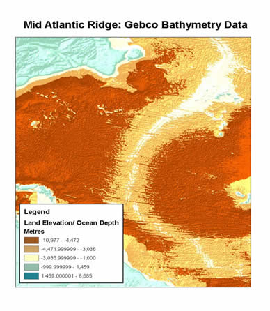
Received from the British Oceanographic Data Centre (BODC) this resource has two datasets. The first is a global one arc-minute grid released in 2003, updated 2008 and is based on the most recent set of bathymetric contours contained within the GEBCO Digital Atlas. The second is a 30 arc-second grid generated by combining quality-controlled ship depth soundings with interpolation between sounding points guided by satellite-derived gravity data.
This dataset provides global gridded elevation data for land surfaces and gridded depths for the world's oceans. Elevations and depths are in metres, at one metre intervals.
Spatial reference and data type
Coordinates are in decimal degrees. The data are in raster format. Other data formats can be accommodated, as the Geospatial Centre has access to a number of conversion utilities.
Use restrictions/licensing/copyright
This data are provided for personal use for academic, research, and/or teaching purposes. Geospatial Centre staff will ask patrons to read and sign a data release agreement before these licensed data can be released. The British Oceanographic Data Centre must be acknowledged on any derivative product, whether printed or electronic, including for example, a printed map, a raster or vector graphic, a web-based application, etc. Patrons are advised to fully respect the provisions of Canada's Copyright Act as well as terms and conditions imposed by the data provider.
Citation
Gebco gridded global bathymetry data. British Oceanographic Data Centre, Liverpool, United Kingdom, 2009.
Sample view of data