Contact the Geospatial Centre
Dana Porter Library, Room 328
University of Waterloo Library
Waterloo, Ontario N2L 3G1
Email: librarygeo@uwaterloo.ca
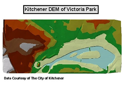
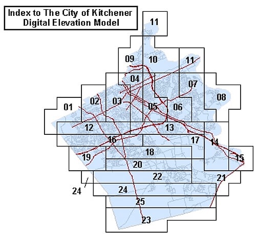
This data resource consists of irregularly-spaced elevation points for the City of Kitchener. This data can be used to create 3 dimensional surfaces for use in elevation and ground surface studies. This data is provided by the City of Kitchener as a series of tiles. An index to these tiles is provided below. Available years: 2011, 2013, and from Ministry of Natural Resources, 2015.
This data set is available in Universal Transverse Mercator (UTM) co-ordinates; horizontal datum is North American Datum (NAD) 83. These data are stored as Esri shapefiles. Other data formats can be accommodated, as the Geospatial Centre has access to a number of conversion utilities. Please see the Geospatial Centre's guide to Converting Digital Elevation Models (DEM) (Word) for a brief outline on how to use this data is ArcView and ArcGIS.
To request this data, please fill out the Ask-Us form and include which layers (shapefiles) you are interested in obtaining. The dataset will be shared with you via OneDrive upon completion of the data release agreement form. You may also make an in-person appointment using the same form.
These data are provided for personal use for academic, research, and/or teaching purposes. A data release agreement must be agreed to before these licensed data can be released. The City of Kitchener must be acknowledged on any derivative product, whether printed or electronic, including for example, a printed map, a raster or vector graphic, a web-based application, etc. Patrons are advised to fully respect the provisions of Canada's Copyright Act as well as terms and conditions imposed by the data provider.
The City of Kitchener Digital Elevation Model [computer file]. Kitchener, Ontario: City of Kitchener Department of Information Services, [2015].