Contact the Geospatial Centre
Dana Porter Library, Room 328
University of Waterloo Library
Waterloo, Ontario N2L 3G1
Email: librarygeo@uwaterloo.ca
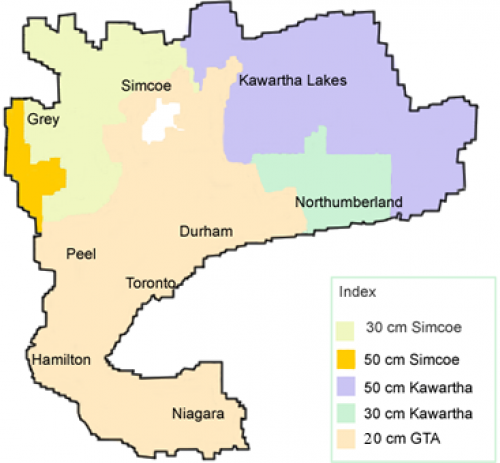
These digital orthoimages provide full-colour aerial coverage of the Greater Toronto Area, Golden Horseshoe and other counties including Grey, Simcoe, and Kawartha Lakes. There is also separate coverage of Lambton County (west of Middlesex County). These images were flown in April 2002 by J. D. Barnes and provided to the Geospatial Centre by the Ministry of Natural Resources in October 2004. The 5-colour map below outlines the extent of the area for which these images are available and also illustrates the range in pixel resolution from 20 cm to 50 cm.
Please note that because not all the images are held locally, some must be downloaded from a remote server in Toronto. A detailed clickable index, prepared by the staff of the Brock University Map Library, provides the 11-digit tile identifier (e.g., 17 6320 48580) for each image. Please use this index to determine the tile identifiers for the images that interest you.
These georeferenced images are available in Universal Transverse Mercator (UTM) coordinates; horizontal datum is North American Datum (NAD) 83. They are stored as compressed MrSID data files, with accompanying Sid World (SDW) files. Average file size for a MrSID image is 4 MB.
To request this data, please fill out the Ask-Us form and include which layers (shapefiles) you are interested in obtaining. The dataset will be shared with you via OneDrive upon completion of the data release agreement form. You may also make an in-person appointment using the same form.
These data are provided for personal use for academic, research, and/or teaching purposes. A data release agreement must be agreed to before these licensed data can be released. The Ministry of Natural Resources must be acknowledged on any derivative product, whether printed or electronic, including for example, a printed map, a raster or vector graphic, a web-based application, etc. Patrons are advised to fully respect the provisions of Canada's Copyright Act as well as terms and conditions imposed by the data provider.
GTA and Adjacent Regions : Orthoimagery 2002 [computer file]. Toronto, Ontario: The Ontario Ministry of Natural Resources, [2002].