Contact the Geospatial Centre
Dana Porter Library, Room 328
University of Waterloo Library
Waterloo, Ontario N2L 3G1
Email: librarygeo@library.uwaterloo.ca
2013 orthoimagery was received February 2014 from the Geospatial Competency Centre, Mapping Services, City of Toronto. Imagery covers the entire City of Toronto and consists of 3,018 tiles each covering an area of 0.5 km2, with an image resolution of 6 cm ground pixel.
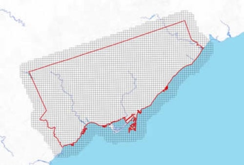
A detailed index (PDF) provides the four digit identifying number for each .5 km tile.
Coordinate system for these georeferenced tiled orthos is Modified Transfer Mercator (MTM) zone 10, North American Datum (NAD) 27. They are stored as compressed MrSID data files, with accompanying Sid World (SDW) files. Average file size for each tile is 52 MB, and the entire set is 102 GB.
In order to access these data sets, please visit the Geospatial Centre reference desk during reference hours. Library reference staff are available to provide further information about these data sets and to deliver data upon request. Under the terms of the library's license agreement, these images are for use by students, faculty, and staff at the University of Waterloo only.
There are public workstations in the Geospatial Centre that provide access to ArcGIS software programs, program extensions and data manipulation utilities. Patrons may use the Geographic Information System (GIS) and image processing software in the library to view and manipulate the data. UWaterloo faculty, students and staff may copy these data to other media (for example: CD, DVD or Zip disc) for use elsewhere.
These images may be exported from ArcGIS in a choice of bitmapped formats (also known as raster graphics) including JPG, TIFF, GIF, and BMP or in a choice of vector graphics formats including Adobe Illustrator (AI), Encapsulated Postscript (EPS), and Scalable Vector Graphics (SVG). Yet another option is PDF.
These data are provided for personal use for academic, research, and/or teaching purposes. A data release agreement must be agreed to before these licensed data can be released. The City of Toronto Geospatial Competency Centre must be acknowledged on any derivative product, whether printed or electronic, including for example, a printed map, a raster or vector graphic, a web-based application, etc. Patrons are advised to fully respect the provisions of Canada's Copyright Act as well as terms and conditions imposed by the data provider.
2013 orthoimagery [computer file], Geospatial Competency Centre, Mapping Services, City of Toronto, Ontario 2013
Data courtesy of the Geospatial Competency Centre, City of Toronto


