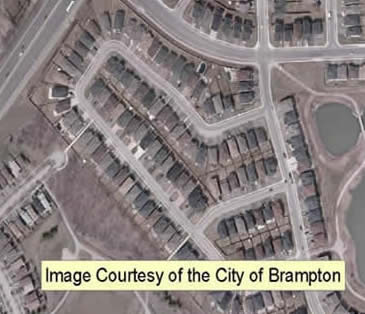
Description
This data resource, consisting of more than 1,300 georeferenced orthoimages, was provided to the Geospatial Centre by the City of Brampton on July 4, 2008. These full colour images were flown in early April 2008 and have 10 cm pixel resolution. Average file size is 3.5 MB.
The city also provided municipal vector data to the library.
Spatial reference and data type
These images are available in Universal Transverse Mercator (UTM) zone 17 co-ordinates; horizontal datum is North American Datum (NAD) 83. Images are stored as compressed MrSID images. Other data formats can be accommodated, as the Geospatial Centre has access to a number of conversion utilities.
Data access
To request this data, please fill out the Ask-Us form and include which layers (shapefiles) you are interested in obtaining. The dataset will be shared with you via OneDrive upon completion of the data release agreement form. You may also make an in-person appointment using the same form.
Use restrictions/licensing/copyright
This resource is provided for academic, research, teaching, and personal use only. A data release agreement must be agreed to before the data is delivered. The City of Brampton should be acknowledged on any derivative product, such as a map or an image.
Citation
The City of Brampton Digital Orthophotos [computer file]. Brampton, Ontario: The City of Brampton, [2008].
Sample view of the data