Data access
Full access to our resources is available to current students, faculty, and staff of the University of Waterloo. To request access, please complete the Ask-Us form indicating the specific layers (shapefiles) you require. Upon completion of the data release agreement form, the dataset will be provided to you via OneDrive.
In-person consultations may also be requested through the Ask-Us form.
Description
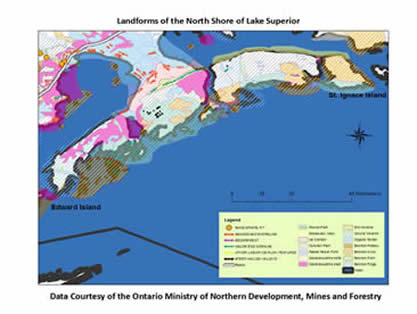
The Northern Ontario Engineering Geology Terrain Study (NOEGTS) data is from the Ontario Ministry of Northern Development, Mines and Forestry and covers all of Northern Ontario up to latitude 51 degrees. The data was obtained from reconnaissance level evaluations of near-surface geological conditions, with a view to determine the terrain conditions and the engineering capability of the terrain.
The main techniques used to gather the information for the study was air photo interpretation combined with literature searches and limited field work. A total of 370,000 km2 of northern Ontario was mapped between 1977 and 1980.
The scale of the NOEGTS data is 1:100,000.
Data set has the following features:
- Beach (raised form)
- Bedrock (plateau, knob, plain, ridge)
- Dunes
- Escarpment
- Eskers
- Glaciolacustrine (delta, plain)
- Ice contact
- Ice-flow linear feature
- Moraines
- Organic terrain
- Pits (sand, gravel)
- Plains (alluvial, outwash)
- Quarries
- Roads
- Shoreline (abandoned)
- Slopewash
- Talus
- Valleys (steep walled)
Spatial reference and data type
These data sets are available in both Universal Transverse Mercator (UTM) coordinate system North American Datum (NAD) 83 datum; and also geographic projection (decimal degrees) NAD 83 datum. These data are stored as Esri shapefiles. Other data formats can be accommodated, as the Geospatial Centre has access to a number of conversion utilities.
Use restrictions/licensing/copyright
These data are provided for personal use for academic, research, and/or teaching purposes. A data release agreement must be agreed to before these licensed data can be released. The Ontario Ministry of Northern Development, Mines and Forestry must be acknowledged on any derivative product, whether printed or electronic, including for example, a printed map, a raster or vector graphic, a web-based application, etc. Patrons are advised to fully respect the provisions of Canada's Copyright Act as well as terms and conditions imposed by the data provider.
Citation
The Northern Ontario Engineering Geology Terrain Study [computer file]. The Ontario Ministry of Northern Development, Mines and Forestry, [2005].
Sample view of the data