News by audience
- Current students (3)
- Future students (2)
- Faculty (3)
- Staff (3)
News archive
Tuesday, April 21, 2015
The Geospatial Centre, in collaboration with the Department of History and the Laurier Centre for Military, Strategic and Disarmament Studies (LCMSDS) at Wilfrid Laurier University would like to share an online "deep mapping" exhibit that was created just in time to mark the 100th anniversary of the Second Battle of the Ypres on April 22.
Deep map of Second Ypres
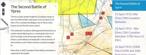
This week marks the 100th Anniversary of what Canadians know as the Second Battle of Ypres. On the afternoon of April 22, 1915, the forward elements of 1st Canadian Division were still preparing their shallow trenches in the farmland just north of Ypres, Belgium. At 5 p.m., reports began of a greenish yellow cloud drifting past the Canadians’ shallow trenches into the ranks of the 45th Algerian Division troops to the west. It was chlorine. Through the next days, the Canadians and British fought to stem the advance of the 26th German Reserve Corps. It was a brutal baptism of fire, giving places like St. Julien, Kitchener’s Wood, and Mauser Ridge a lasting place in the Canadian imagination. It was in response to this battle that Colonel John McCrae lamented a friend by writing "In Flanders Fields." The cost was grim: over 6,000 Canadians, or one in three, became a casualty. Over 2,000 Canadians died between April 22 and May 25, 1915 to defend Ypres. Most of those graves are lost; their names are found on the walls of the Menin Gate that leads into the centre of Ypres.
This "deep map" of Second Ypres gives viewers a chance to "see" the battle from different perspectives. It follows the battle’s first stages in April, drawing from archival material to help us explore the fighting through those crucial days. It gives special focus to the Canadian and British troops who won the Victoria Cross during the battle. It also captures the commemorative landscape that followed the battle, from the St. Julien Canadian Memorial with its brooding soldier, to the dozens of cemeteries that are found throughout the countryside.
The exhibit also lists the nearly 65,000 Canadian war dead from the First World War on a timeline.
Researchers can follow the fatal cost of the war day by day. Some 387 Canadians died on April 22, 1915. Among them were Thomas James Young of the 16th Battalion (Canadian Scottish, Victoria, B.C.) who died, likely in the fighting for Kitchener’s Wood. Tags allow us to discover that Private Young was among the first of 1,351 fatalities suffered by the Canadian Scottish over the next four years.
This "deep map" is the first of a series that examines both world wars in new and innovative ways. It is a collaboration between the Department of History and the Geospatial Centre, University of Waterloo, and the Laurier Centre for Military, Strategic and Disarmament Studies (LCMSDS) at Wilfrid Laurier University. Waterloo History graduate student Brandon Strnad is the principal author of this exhibit.
Feel free to explore the map. Learn something new about an important event in the life of Canada.
For more information contact:
Geoffrey Hayes
Associate Professor, Department of History, University of Waterloo
519-888-4567, ext. 35138


