Design team members: Charles Bergeron and Dan Kossowski
Supervisor: Prof. David A. Clausi
Background
The Canadian Coast Guard is responsible for ensuring the safe use of Canada's waters, facilitating the use of our waters for shipping, and providing marine expertise. Icebreaking and providing information to vessels operating in ice-infested waters constitutes a key component of their mission. The Canadian Ice Service (CIS) assists in this task by monitoring sea ice conditions through vessel reports, aircraft reconnaissance, and remote satellite technology. This information is used to create ice maps that identify ice conditions. These maps then allow ships to navigate a path of least resistance.
Problem statement
The CIS relies on operators to draw ice maps based on the inspection of remote sensing data and other available information. The operator’s visual interpretation of satellite imagery and knowledge of ice types is inevitably prone to human error. The development of a system to assist the operator in recognizing ice conditions would increase the accuracy of these maps and reduce their update period.
Solution statement
This project aims to identify useful features of ice types on a SAR image corresponding to a hand-drawn ice map, and generate an updated ice map by applying these features to ice type classification on a second SAR image.
Project description
This project aims to extract features from the RADARSAT-1 image of the northern half of the Saint-Lawrence Gulf acquired on 9 February 1999 that appears as Figure 1, and seek these features in a second RADARSAT-1 image acquired seven days later.
In the learning phase, textual features are identified in the first SAR image for each of the ice zones corresponding to difference ice conditions, as classified in the operator-drawn ice map generated for 9 February 1999 that appears as Figure 2.
In the implementation phase, these features are recognized in the latter SAR image and the ice map is then updated to reflect shifts in ice conditions.
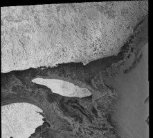
Figure 1: A RADARSAT-1 image of the northern Saint-Laurence Gulf on 9 February 1999. A Canadian instrument, RADARSAT-1 is an active radar sensor that operates at a frequency of 5.3 gigahertz.
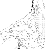
Figure 2: An Ice Map of the Saint-Lawrence Gulf on 9 February 1999. Ice maps are generated to facilitate the navigation of vessels during the winter and spring months. Each zone identified by a letter corresponds to specific ice conditions.
Design methodology
In order to attain the project's objectives, the following tasks are undertaken:
-
To project and geocode the SAR images, and create a subscene that is common to them.
-
To reformat and georeference the ice map.
-
To identify ice zone characteristics from visual inspection and basic statistic evaluation.
-
To extract and classify features from the first SAR image.
To identify these features in the second SAR image and update the ice map accordingly.
Being a research and development project, the methodology is inevitably modified as new information is discovered.
Internet resources
The
Radarsat
International
website
contains
information
about
the
RADARSAT-1
instrument.
The
Canadian
Ice
Service
website
includes
information
about
ice
types
and
classification.