Contact the Geospatial Centre
Dana Porter Library, Room 328
University of Waterloo Library
Waterloo, Ontario N2L 3G1
Email: librarygeo@uwaterloo.ca
As part of an Ontario Council of University Libraries (OCUL) initiative, the Geospatial Centre has scanned, and made available to the public archival (1957 – 1966) 1:25,000 topographic (NTS) maps. The high-quality TIF files were scanned at 600 dpi, and have an average file size of 750 MB.
To access files, please come to the Geospatial Centre during reference hours.
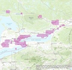 Index showing coverage extent.
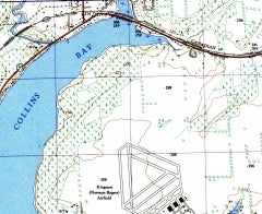 Simcoe Island (1959)


